Jeff McGuire1, Terry Plank2
1Woods Hole Oceanographic Institution, 2Lamont-Doherty Earth Observatory, Columbia University
On September 29-October 1 2016 an International Workshop was held in Boise Idaho to discuss what a Subduction Zone Observatory initiative could accomplish and what form it might take. The workshop was proposed by the IRIS, UNAVCO, Earthscope, and GeoPRISMS offices in response to the high level of community interest over the past years. The SZO workshop was sponsored primarily by the U.S. NSF, with support coming from eight different programs within the GEO division as well as the Office of International Science and Engineering. Additionally, the USGS supported over twenty of its scientists to attend and the Earth Observatory of Singapore supported the attendance of over fifteen scientists from a number of countries in Southeast Asia. By design, the meeting was exceptionally diverse: of the 242 scientists in attendence, 67 were early career investigators and graduate students and 45 were from 21 different countries outside the U.S.
The workshop was organized around four themes:
- Deformation and the Earthquake Cycle;
- Volatiles, Magmatic processes and Volcanoes;
- Surface Processes and the Feedbacks between Subduction and Climate; and
- Plate Boundary Evolution and Dynamics.
Thirty-two breakout sessions over the course of the meeting gave attendees abundant opportunity to weigh in on the most important scientific opportunities, the key obstacles holding back discoveries, and the types of future community scale efforts that would best advance subduction zone science. Participants were asked “What is new, exciting, and doable?” and “What can’t we do now?”. Additionally, over sixty whitepapers were submitted with ideas about what an SZO might look like and four webinars were conducted that discussed opportunities afforded at different locations around the world. The presentations, break out reports, white papers, and webinars are all available for viewing on the workshop website.
Much of the scientific enthusiasm at the workshop resulted from recent examples of spectacular new types of datasets that provide a window towards a next generation approach to understanding Subduction Zones. Many phenomena that were previously captured as static snapshots are now starting to be shown as movies, in 4D. From the locking of the plate boundary fault, to the gases expelled from volcanoes prior to eruption, to the surface mass transport between forearc mountains and the trench, to geological records of past ruptures spanning back thousands of years, newly available observational time series are revealing dynamically evolving processes.
The key to understanding both the basic science and the societal hazard requires recording this 4D evolution and being able to quantitatively model it. Synergistically, the sensors deployed for basic research are finding evermore practical applications. Earthquake and tsunami early warning, volcanic ash observatories and dispersion models linked with global air traffic control, eruption warnings based on volcanic unrest, incipient landslides detected by satellites, all rely on sensor suites that now serve the dual purpose of a greater scientific understanding and a reduction in societal hazards. The technology for studying subduction zones is exploding in many ways but this has not yet been translated to the necessary scales to accelerate discovery and improve warning systems.
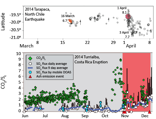
Examples of timeseries data prior to earthquakes and eruptions. 8.1 Tarapaca earthquake (from Brodsky and Lay, Science, 2014) and 2014 eruption of Turrialba volcano (from deMoor et al., JGR, 2016). Timeseries show notable events in the weeks preceeding the mainshock (1 April 8.1) and eruption (pink bar), in the form of migrating swarms of foreshocks and a rise in the CO2/S ratio of gas, respectively. Such events are rarely captured, but generated excitement at the SZO Workshop as emergent phenomena that require a coordinated, multidisciplinary effort.
USGS scientists presented an overview of their plans for new research directions aimed at reducing geohazards from subduction zone eruptions, earthquakes, tsunamis, and landslides. There was considerable debate during the workshop about the relationship between basic science in subduction zones and mission-oriented science aimed at hazard reduction. An SZO initiative will undoubtedly have an impact on both and must carefully articulate its synergistic efforts with the USGS, NASA, and NOAA. In practice, there is considerable overlap between these two goals and many of the same fundamental questions and observational datasets are key to each. Moreover, it was recognized that hazard reduction will be the single most important driver of many of our international collaborators who will be critically important in making SZO a global scale initiative. Hazards will also form the key focus of many education and outreach efforts that could produce a significant impact if approached at the community scale. Overall, the workshop supported a primary driving goal of any SZO initiative to be the development of a deeper understanding of the physical and chemical processes that underlie subduction zone hazards.
The Cascadia and Alaska subduction zones lie within U.S. borders and present a pressing array of unsolved problems and opportunities in subduction zone science. Key hazards to U.S. populations drive the basic science community and the mission agencies to collaborate. However, the workshop participants also emphasized the need to go global to really understand subduction zone processes. Many regions present unique opportunities, such as the ability to drill the seismogenic zone, extremely active volcanic arcs, seismic gaps with centuries of strain accumulation, and likely tsunami earthquakes, that provide a natural potential to capture key phenomena. Moreover, many subduction processes have natural cycles on the scale of decades or centuries and the only way we will piece together a complete understanding of the whole cycle is to piece together what we can learn from different regions that are currently at different stages of that cycle.
Workshop participants recognized that a variety of programatic approaches will advance subduction zone science, that many styles have been successful in the past, and different aspects could be phased in over time. Three key components were identified:
- A Community Modeling Collaboratory,
- An Interdisciplinary Science Program, and
- A Large Scale Infrastructure Program.
This combination over a 10-year effort could reveal new phenomena, integrate data with models, and lead to hazard forecasting that is informed by fundamental tectonic, physical, and chemical drivers. A diverse committee of scientists is currently writing up a detailed report on the priorities and strategies identified during the meeting. The report is on target to be put up for comment in late 2016 and finalized in early 2017. ■
Reference informationGeoPRISMS Newsletter, Issue No. 37, Fall 2016. Retrieved from http://geoprisms.nineplanetsllc.com