The GeoPRISMS Data Portal was established in 2011 to provide convenient access to data and information for each primary site as well as other data resources. Since the last newsletter report, the database group participated in the EarthCube workshop for the DEFORM/Compress communities, worked with Jim Gill on a data rescue effort to compile decades of geochemical analyses for the Izu arc, released the version 2.7.0 of PetDB which includes enhanced data access functionality, and expanded the on-line GeoPRISMS bibliography that now offers 730 citations, many linked to data. Highlighted below are other recent contributions of data sets and field program information of interest to the GeoPRISMS community.
Cascadia
Open-access cleaned CTD data from AT26-04, the summer 2013 Atlantis heat flux cruise run by Paul Johnson, Evan Solomon and Rob Harris, was added to the portal. For Cascadia Initiative Year 3 operations, ocean bottom seismometer deployment & recovery information, and other field details are now available. Instrument tables for Years 1, 2 and 3 of OBS operations have also been updated in GeoMapApp, where they are listed under the Focus Site menu. Using more than a thousand stations including EarthScope USArray TA instruments, Haiying Gao and Yang Shen generated a shear wave velocity ambient noise tomographic model of Cascadia, now linked from the portal (Fig. 1).
ENAM
Covering the magma-starved West Iberia-Galicia passive rifted margin, site of last year’s Langseth 3-D seismic experiment (cruise MGL1307 led by Dale Sawyer, Donna Shillington, Tim Reston, Cesar Ranero and Juli Morgan), a new 500 m EMODnet bathymetric grid compilation of European data was added to GeoMapApp (Fig. 2a). The grid is available under the Base Maps > Bathymetry > North Atlantic menu.
Central America
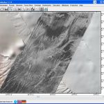
Spectacularly-detailed gridded data sets of bathymetry and acoustic backscatter were contributed by investigators Jared Kluesner, Nathan Bangs, Cesar Ranero, Kirk McIntosh and Eli Silver who, as part of the CRISP imaging project (Langseth cruise MGL1106), acquired high-quality 3-D seismic data across the Costa Rica shelf and slope in 2011. Novel range-angle data processing techniques that took advantage of a close line spacing and overlapping swaths allowed the EM122 multibeam sonar data to be gridded at an unprecedented 10 m interval for bathymetry and 5 m for backscatter (Fig. 2b). The grids have been added to GeoMapApp, under the Focus Site > Central America menu, and are available for download from the Langseth cruise web page.
Gulf of California
As part of a collaborative data curation effort with the Hawaii Mapping Research Group towed IMI30 bathymetry and sidescan data (grids, images and underlying data files) are now available through the portal for Dan Lizarralde’s 2009 Atlantis cruise AT15-54 to the Guaymas Basin area, part of the MARGINS Gulf of California focus site.
-
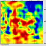
- Figure 1. The Gao and Shen 2014 shear wave velocity model of the upper mantle from full-wave ambient noise tomography reveals low-velocity anomalies (dark reds) along the Cascade back-arc. This horizontal slice was generated using the IRIS visualisation tool, for a depth of 94 km (Vs in km/s). The seismic velocity model is linked from the GeoPRISMS Data Portal and is tied to references.
-
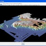
- Figure 2 (a). Conjugate to the Newfoundland margin, the Galicia margin is shown in this perspective view of the new EOMDnet 500 m bathymetric compilation from http://portal.emodnet-hydrography.eu/ North is to the upper left, with the Iberian shelf in the upper right. The displayed area measures about 700 km across.
-
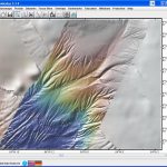
- (b) A dense spacing of track lines was laid down for Langseth cruise MGL1106 – the CRISP 3-D multi-channel seismics Costa Rica experiment. With 4-5 overlapping sonar swaths, new processing methods were used by Kluesner and colleagues to generate highly-detailed bathymetry (medium) and backscatter (bottom) grids. The data sets were used to identify previously undocumented sites of potential fluid seeps associated with normal faults, and with bathymetric features such as pockmarks, mounds, ridges as well as with areas of high backscatter reflectance. In the GeoPRISMS/MARGINS integrated Data Portal, the data sets are linked to the Kluesner et al., 2013 G cubed paper. The map displays an area about 25 km across.
GeoPRISMS Data Portal Tools and Resources
Search For Data – The customised GeoPRISMS search tool provides a quick way to find GeoPRISMS data using parameters such as key word, NSF award number, publications, and geographical extent.
Data Management Plan tool – generate a data management plan for your NSF proposal. The on-line form can be quickly filled in, printed in PDF format, and attached to a proposal. PIs can use an old plan as a template to create a new plan. We also have developed a tool to help PIs show compliance with NSF data policies.
GeoPRISMS Bibliography – with more than 700 citations, many tied to data sets, the references can be searched by primary site, paper title, author, year, and journal. The lists of publications can be exported to EndNote™. Submit your papers – just the DOI is needed – for inclusion in the bibliography!
GeoMapApp – a free map-based data exploration and visualization tool was updated with the release of version 3.3.9 in February 2014. Enhancements include default caching of the multibeam portal, improved handling of imported and exported Excel™ spreadsheets, an updated Earthquake Focal Mechanisms portal that now contains data up to August 2013, a Projection menu that allows users to switch map projection without leaving the interface, an expanded FAQ web page, and a modified grid manipulation window. Version 2.5 of the GMRT base map includes swath bathymetry for Cascadia and other areas. A GeoPRISMS-focused webinar is available on the GeoMapApp Youtube channel and shows how to generate custom maps, how to explore built-in data sets of interest to the GeoPRISMS community, and how to import your own data.
Contribute Data – this updated web tool provides a simple way to submit grid files, tabular data sets, spreadsheets, and shapefiles. Once added to the GeoPRISMS database, these data sets become available to the broader community immediately or can be placed on restricted hold.