The GeoPRISMS data portal was launched in May 2011 as a new portal of the MGDS database. For each GeoPRISMS primary site, the portal has been populated with information and links to a range of existing, high-priority data sets. For example, for the Alaska-Aleutians primary site, the portal provides information on this summer’s multi-channel seismic cruises aboard Langseth: MGL1109 – the USGS-led survey in support of the US Extended Continental Shelf (ECS) claim with chief scientists Ginger Barth and Sean Gulick, and cruise MGL1110 – the Alaska Megathrust survey spearheaded by Donna Shillington, Mladen Nedimovic and Spahr Webb. Also included are links to the many USGS seismic surveys such as the TACT and EDGE lines along the arc and to Casey Moore’s rock sampling and mapping work on Kodiak island.
Cascadia
In the Cascadia area, chief scientist Chris Romsos guided the collection of new multi-beam bathymetry data aboard Thompson cruise TN265 to help determine the siting of Cascadia Facility Ocean Bottom Seismometers. Links to the seven phases of the USGS Cascadia SHIPS seismic projects are also given for this primary site.
ENAM
For the ENAM region, the GeoPRISMS data portal provides access to data from the Canadian LITHOPROBE-FGP seismic imaging initiative, as well as from USGS seismic surveys. A range of cruise-based data is also available including the Mountain-Miller MCS survey across the New Jersey slope; SCREECH seismic lines around the Flemish Cap margin; and, high-resolution multi-beam bathymetry as part of the US ECS claim (Fig. 1).
-
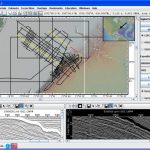
- Figure 1. GeoMapApp screenshot showing Ewing EW9009 MCS lines 1002 (lower left) and 1005 (lower right, with inverse video turned on) across the New Jersey slope. The seismic lines are displayed on the map in yellow, with red portions representing the extent of the two profiles shown in the lower panes. A digitizer function allows horizons to be quickly delineated and saved to disk. The base map is the global multi-resolution topographic synthesis that offers 10m horizontal resolution of ENAM’s on-land elevations and 100m or better resolution in the oceans and on the shelves.
-
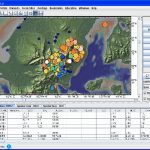
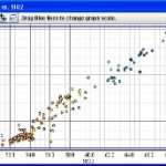
- Figure 2. EarthChem geochemistry data from the Alaska Peninsula imported to GeoMapApp. Sample location symbols are colored on MgO and scaled on TiO2. Identification of data trends is enhanced with GeoMapApp’s graphing function (right, with K2O plotted against SiO2). Samples can be selected using a lasso tool and both the samples and map view can be exported.
GeoPRISMS Search For Data
The portal offers a customized search-for-data interface to help researchers speed their way to GeoPRISMS-related data. The search can be done on a key word such as data type or investigator or by searching within a geographical box, as well as on NSF award number or for data sets related to publications.
A Google Maps™-based interactive map shows ship survey tracks, stations and samples from GeoPRISMS-related expeditions within each of the primary sites. Clicking on a track or station invokes a link to the associated data sets and field program information. Statistics on data file downloads are compiled annually and sent to the contributing scientists.
Data Management Plan tool – NSF now requires that each submitted proposal includes a data management plan. To help investigators meet this requirement, we developed an on-line tool that can be quickly filled in by PIs and printed in PDF format ready for attachment to a proposal. We are also developing a tool to help PIs show their compliance with data policies.
GeoPRISMS Bibliography – An integrated, searchable GeoPRISMS bibliography has been created. It currently contains more than 170 references related to GeoPRISMS science, with papers tied to associated data sets. The lists of publications can be exported to EndNote™.
GeoMapApp – GeoMapApp, a free map-based data exploration and visualisation tool, incorporates the latest version of the underlying global elevation model (the GMRT synthesis) that includes cleaned multi-beam swath tracks from more than 560 research cruises; there is also a 50m-resolution layer on some continental shelves. Global land elevations comprise 30m NASA-Japanese ASTER data, with very high-resolution 10m USGS NED data for the entire US lower 48 states landmass. Users can import their own data tables and grids and manipulate them with the full range of GeoMapApp functionality (Fig. 2). Multimedia audio-visual tutorials are available on the GeoMapApp web page and on YouTube™.
Virtual Ocean – offers GeoMapApp-style capabilities in 3-D. A wide range of built-in data sets is available and, as with GeoMapApp, data tables can be imported and manipulated, and custom maps can be generated.
GeoPRISMS MediaBank – provides access in a gallery format to GeoPRISMS-related images including photos from field expeditions. Please send compelling images for inclusion in the GeoPRISMS MediaBank gallery.
The GeoPRISMS data portal team is here to help the community. Please contact us at info@marine-geo.org.