Sunday December 11, 2016, 8am-1pm
Conveners: Rick Aster, Pascal Audet, Katherine Boggs, Julie Elliott, Roy Hyndman, Michael Schmidt, Derek Schutt (Colorado State)
Related article: BOGGS, Katherine J.E. et al. EON-ROSE and the Canadian Cordillera Array – Building Bridges to Span Earth System Science in Canada. Geoscience Canada, [S.l.], 97-109, 2018. ISSN 1911-4850. doi.org/10.12789/geocanj.2018.45.136.
8:00 AM | Introduction to GeoPRISMS – Demian Saffer, GeoPRISMS Chair
8:20 | Introduction – Rick Aster (Colorado State University), Workshop Chair
8:35 | Principal scientific targets, geology, structure and tectonics of the western Canadian plate boundary – Roy Hyndman
8:55 | Seismological and general state of knowledge from previous and ongoing work – Pascal Audet
9:15 | Tectonics of the Gulf of Alaska and what understanding structures and processes in the Yukon-BC would bring to understanding of the broader region – Lindsay Worthington
9:35 | Science targets for improved geodetic coverage in western Canada – Julie Elliott
9:55 | Break
10:15 | Science targets for offshore geophysical instrumentation in western Canada – Mladen Nedimovic
10:35 | An induced seismicity program for western Canada, and past and current relevant induced seismicity work – David Eaton
10:55 | Summary of recent Canadian workshops and a large-scale geophysical study of western Canada – Katherine Boggs
- Critical Zone Observatories – Nicole West
- TREx – The Transition Region Explorer – Eric Donovan
- Presentation – Frank Vernon
11:15 – 1:00 | All
Round Table discussion of next steps. Key topics will include further discussion of science motivation—both from a GeoPRISMS and broader set of perspectives, possible collaborations with broader scientific, resource, hazard, and other communities, funding opportunities, and possible timing and logistical alignments with USArray and PBO post-EarthScope, and marine instrumentation resources.
The purpose of this mini-workshop is to build terrestrial and marine partnerships to complement and frame the nascent EarthsCAN initiative, which seeks to fund ambitious large-scale geophysical studies in Canada across the next decade. This workshop will provide a timely and valuable US-based venue to convey and further discuss relevant results from three Canadian EarthCAN workshops being conducted in 2016, and promote future collaboration between the Canadian research community and their US and international colleagues.
Invited Speakers
- Pascal Audet (University of Ottawa), and Katherine Boggs (Mount Royal University), will discuss the EarthsCAN initiative, potential pilot deployments in the Yukon and British Columbia, and the outcomes of the three Canadian EarthsCAN workshops.
- Lindsay Worthington (University of New Mexico) will talk about the tectonics of the Gulf of Alaska and what understanding structures and processes in the Yukon-BC would bring to understanding of the broader region.
- Roy Hyndman (Pacific Geoscience Centre) will discuss what is known and unknown regarding the tectonics and structures in the Yukon-B.C. region.
- Mladen Nedimović (Dalhousie University) will discuss subduction-related water flux at the Juan de Fuca plate, and the benefits of extending work to the north of the Olympic Peninsula.
Overview
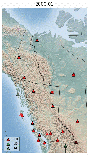
This GeoPRISMS Mini-Workshop will focus on the interaction between past and present subduction, transform faults, and the corresponding lithospheric modification of the British Columbia-Yukon region. The workshop will include a discussion on a proposed ~200 station US Array-scale broadband network and potential GPS network from the U.S. border to the Yukon and Beaufort Sea. The project would leverage ongoing USArray, EarthScope, and other U.S. and Canadian efforts in Cascadia, the Yukon, and southeastern Alaska, and tie together the increasingly well-studied south Alaska and Pacific Northwest plate margins. The proposed initiative would complete synoptic GPS, tomographic, and seismicity coverage of the plate boundary/cordilleran transition zone, when incorporated with ongoing oceanic and land-based instrumentation associated with the Transportable Array, the Plate Boundary Observatory, and field deployments in the Alaska/Yukon region.
Interest from Research Community
We are seeking to build terrestrial and marine partnerships to complement and frame the nascent EarthsCAN initiative, which seeks to fund ambitious large- scale geophysical studies in Canada across the next decade. This workshop will provide a timely and valuable US-based venue to convey and further discuss relevant results from three Canadian workshops (held in Whitehorse, Calgary, and Ottawa) being conducted this year, and promote future collaboration between the Canadian research community and their U.S. and international colleagues.
Scientific Motivation
The British Columbia-Yukon corridor includes a number of world-class science targets, including: 1) a spectrum of plate boundary styles, ranging from Cascadia subduction to transpressional convergence at the Haida Gwaii, to strike slip in the Queen Charlotte Transform fault zone; 2) a complex history of terrane collision and consequent lithospheric modification; 3) transfer of strain away from the plate boundary and its relation to intraplate strain partitioning and orogenesis (e.g., Coastal, Mackenzie, and Richardson Mountains); 4) mantle dynamics of the plate margin and transition zone, including the presence and influences of possible slab window effects, mid-lithospheric detachments, terrane, and fossil slab structures.
Connection to GeoPRISMS Goals
GeoPRISMS initiatives in Cascadia and Alaska along with other recent projects in the north Pacific region have changed our understanding of the region’s tectonics. Instead of simple plate boundaries, complex, interconnected plate boundary zones accommodate plate motion. Strain is transferred significant distances both inboard (as demonstrated by small rotating blocks and deformation zones in Alaska and the Pacific Northwest) and outboard (fragmentation of the Pacific plate in the Gulf of Alaska) of the main plate boundary faults. Reorganization of strain partitioning may occur on relatively short geologic timescales. These new insights have forced a reevaluation of seismic hazard and landscape evolution. Several studies have suggested that the effects of the Yakutat block collision with southern Alaska transfer eastward into British Columbia and the Yukon, but much less is known overall about these areas. A concentrated focus on the British Columbia-Yukon border would fill in a missing link in North Pacific tectonics and examine how the Alaska-Yukon-British Columbia-Cascadia system interconnects and influences tectonics in each region. The complex tectonic history of the region, including a long history of subduction and subduction-related magmatism, accretion and movement of exotic terranes, and potential slab windows, offers a chance to look at long term effects of subduction, and the lack thereof, on the plate margin and continental assembly. Notably, of the five Overarching Themes listed in p. 2 of the GeoPRISMS science document, this region bears on several of them, namely: “(a) Origin and Evolution of Continental Crust; (b) Fluids, Magmas and Their Interactions; and (e) Plate Boundary Deformation and Geodynamics.” Consequently, it is envisioned that the GeoPRISMS community will be interested in potential off-shore and on-shore experiments that would pair with instruments being deployed, and analyses being made, as part of the EarthsCAN initiative.
Workshop Goals
(modified from the goals of the May 31, 2016, Whitehorse EarthsCAN workshop)
- Inform the wider community about the outcomes and findings of the three Canadian EarthsCAN workshops
- Discuss GeoPRISMS-relevant science goals that can be addressed by augmenting existing EarthScope and Canadian networks in the area spanning from the Pacific Northwest (WA, OR, MT, ID) through British Columbia, Yukon, NWT, and Alaska
- Outline possible pilot projects and scientific targets, including on-shore/off-shore arrays
- Build new interdisciplinary community ties, and encourage the interest of new researchers
- Provide a list of recommendations and summary white paper that builds on the work done in the three Canadian workshops.
GeoPRISMS AGU Mini-workshop, EarthScope-type Canadian Cordillera Seismic Array and GPS Network
December, 11, 2017 | San Francisco, CA
Organizers: Rick Aster (Colorado State University; chair), Pascal Audet (University of Ottawa), Katherine Boggs (Mount Royal University), Julie Elliott (Purdue University), Roy Hyndman (Pacific Geoscience Centre), Michael Schmidt (University of Calgary), Derek Schutt (Colorado State University)
On Sunday, December 11, an international and interdisciplinary group of ~50 researchers met in San Francisco under GeoPRISMS support to discuss emerging interest in a Canadian Cordillera Earth Observation Network. The network is conceived to holistically image broad Earth systems along the Pacific Plate Margin and Canadian Cordillera between Alaska and the U.S. Pacific Northwest. This initiative emerged out of four workshops and a planning meeting held in multiple locations in Canada over the last year, working with a broad range of U.S. and international collaborators. The San Francisco workshop pulled together interested researchers from across the U.S. and Canada, including representatives associated with from GeoPRISMS, IRIS, UNAVCO, NSF, industry, academic institutions, and a wide range of Canadian institutions.
After brief introductions by GeoPRISMS chair Demian Saffer (Penn State U.) and workshop chair, Rick Aster (Colorado State U.), Roy Hyndman (Pacific Geoscience Centre) began a sequence of overview talks, by outlining the fundamental tectonic questions ranging from ridge subduction at the north end of the Cascadian forearc, to the Yakutat mini-Himalaya collision along the Gulf of Alaska, to the Canning-Mackenzie overthrust in the Beaufort Sea. Hyndman noted the mainly dextral slip along the Queen Charlotte Fault has a recently revealed partitioned thrust component, as was recently illustrated by the 2012 Mw 7.8 Haida Gwaii earthquake which created a notable (but very sparsely observed) tsunami.
Evolution of BB seismic networks (Pascal Audet)
Pascal Audet (U. of Ottawa) presented an overview of existing seismic and other geophysical studies within the Canadian Cordillera, and pointed out the very significant geographic gaps in coverage. Broadly speaking, the proposed project can build on the exceptional legacy of LITHOPROBE across Canada. However, resolution of crustal and mantle structure across the region, and the understanding of seismicity and deformation, is comparable at best in many subregions to that of the western U.S. prior to the deployment USArray.
Talks by Lindsey Worthington (U. of New Mexico) and Julie Elliott (Purdue U), described the complex tectonic collisional and transpressional setting of the Gulf of Alaska plate margin. The eastern edge of the Yakutat Block is currently poorly defined, and seems to be driving deformation well into the interior of northern Canada, resulting in a (presently very poorly imaged) Canning-Mackenzie overthrust in the Beaufort Sea, and the arcuate thrust belt of the Mackenzie Mountains, 700 to 1000 km from the plate boundary. Additionally, Julie Elliott pointed out the wide range of scientific and societal contributions that could be made by a larger permanent GNSS network in the region, including examining the deep earth, hydrosphere, cryosphere, atmosphere, industry, surveying/land use, agriculture, and natural hazards.
Mladen Ndemovic (Dalhousie U.) presented on the need for marine seismic surveys and instrumentation from the north end of the Cascadia forearc to the Alaskan Panhandle, as well as in the Beaufort Sea.
David Eaton (U. of Calgary) described induced seismicity in the Western Canadian Sedimentary Basin (WCSB) along the eastern margin of the Canadian Cordillera and its link with hydraulic fracturing. The importance of elastic stress changes in contributing to induced seismicity in the WCSB and improved understanding of induced seismicity could lead towards improving our general understanding of earthquakes, and to the conditions under which fracking can create appreciable earthquakes.
Kristin Morell (U. of Victoria) outlined the need for LIDAR, paleo-trenching, and detailed fieldwork to define active faults on Vancouver Island. Nicole West (Central Michigan University) provided an overview of the critical zone, and the need for critical zone monitoring in a range of tectonic and environmental regimes not covered in the US NSF-funded Critical Zone Observatories. It was noted that the critical zone is also the near-surface “geotechnical zone” which defines many aspects of seismic hazard, as well as a general zone of high-frequency seismic wave propagation complexity.
Frank Vernon (U. California, San Diego) and Eric Donovan (U. of Calgary) discussed motivations and benefits of a full geophysical suite of instrumentation at some sites, including for atmospheric sciences and ionosphere/magnetosphere/space physics. Donovan suggested opportunities for collaboration with the Canadian and European Space Agencies through the SWARM program as an example of a multi-national non-traditional research network that could be emulated within the proposed array.
Community discussion after the talks focused on possible next steps for international coordination to move potential projects forward. These details include timely exploration of partnerships that can strongly leverage funding, logistical, and potentially available equipment partnerships in step with the planned sunsetting of current EarthScope USArray and other efforts in Alaska and far northwestern Canada.
[put_wpgm id=5]