The GeoPRISMS data portal was established in 2011 to provide convenient access to data and information for each primary site as well as to other relevant data resources. Since the last newsletter report, highlighted below are recent contributions of data sets and field program information of interest to the GeoPRISMS community. Most of the data sets described are also available in GeoMapApp under the Focus Site menu.
ENAM
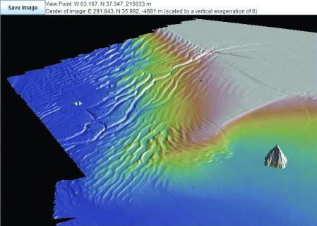
Bathymetry and backscatter data collected as part of a US Extended Continental Shelf survey of the central ENAM margin was contributed by James Gardner and Brian Calder. The new data, shown in figure 1, was generated during Langseth cruise MGL1512 in 2015 and marks the completion of bathymetric data surveying along the entire length of the margin.
Also added to the portal for the ENAM area was field program information for the Mid-Atlantic Geophysical Integrative Collaboration (“MAGIC”) seismometer network. Using data from the array, project PIs Maureen Long, Maggie Benoit, Eric Kirby, and Scott King are studying crustal and upper mantle structure in the area of the Appalachian Mountains. The seismic station locations were also added to GeoMapApp, under the Focus Sites menu.
New Zealand
PIs Robert Harris, Anne Trehu, and Andy Fisher contributed multi-channel seismic shot and processed heat flow data sets collected across the Hikurangi subduction margin during the 2015 “STINGS” cruise. That Revelle expedition surveyed both the northern part of the margin – a creep-dominated subduction interface with shallow slow slip earthquakes (SSEs) – and a southern area with deep SSEs.
Cascadia, Alaska, and Hikurangi margins
Drill core and sediment sample analysis spanning each GeoPRISMS SCD primary focus site is being used by PI Neal Blair to assess the role of multicycle carbon at subduction margins. Links to the analytical geochemical data sets and to related publications are provided in the Portal. DOIs were assigned to the data sets, allowing them to be a formally-cited part of the scientific record.
Aleutians
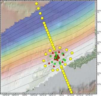
During summer 2015, PIs Ninfa Bennington and Kerry Key led a shoreline-crossing field program in the vicinity of Okmok Island. MT instruments were deployed in onshore and offshore locations as part of an experiment to study the magmatic system beneath the volcano (Fig. 2). A suite of broadband seismometers installed on the island will be picked up later this year. The MT and seismic instrument stations were also added to GeoMapApp.


GMRT base map
The Global Multi-Resolution Topography (GMRT) synthesis – The base map used in GeoMapApp, in the GMRT MapTool, and other IEDA tools now includes processed multibeam swath bathymetry data from more than 270 cruises within GeoPRISMS primary sites. A new GMRT MapTool profiling tool and expanded export options provide improved user flexibility.
GeoPRISMS Data Portal Tools and Other Relevant IEDA Resources
Search For Data – The GeoPRISMS search tool provides a quick way to find GeoPRISMS data using parameters such as keyword, NSF award number, publications, and geographical extent.
Data Management Plan tool – (www.iedadata.org/compliance) Generate a data management plan for your NSF proposal. The on-line form can be quickly filled in, printed in PDF format, and attached to a proposal. PIs can use an old plan as a template to create a new plan. We also have developed a tool to help PIs show compliance with NSF data policies.
GeoPRISMS Bibliography – With more than 1,120 citations, many tied to data sets, the references database can be searched by primary site, paper title, author, year, and journal. The citations can be exported to EndNote™. Submit your papers for inclusion in the bibliography – just the DOI is needed!
Contribute Data – The web submission tools support PI contributions of geophysical, geochemical, and sample data. File formats include grids, tables, spreadsheets, and shapefiles. Once registered within the IEDA systems, the data sets become available to the broader community immediately or may be placed on restricted hold. Additionally, PIs can choose to have a DOI assigned to each submitted data set, allowing it to become part of the formal, citable scientific record.
