The GeoPRISMS data portal was established in 2011 to provide convenient access to data and information for each primary site as well as to other relevant data resources. Since the last newsletter report, highlighted below are recent contributions of data sets and field program information of interest to the GeoPRISMS community. Most of the data sets described are also available in GeoMapApp under the Focus Site menu.
During summer 2015, Data Portal staff helped the GeoPRISMS Office expand the on-line, searchable GeoPRISMS bibliography which now contains more than 1,120 citations and includes links to papers, data sets, and field expedition information.
New Zealand
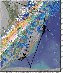
Basic field expedition information was added to the Portal for two Revelle cruises to the Hikurangi subduction margin: The “STINGS” expedition led by PIs Robert Harris, Anne Trehu, Stuart Henrys, and Andy Fisher that collected heat flow and seismic data to help understand the region’s thermal structure (RR1508); and, the “HOBITSS” cruise in which sea-bottom pressure gauge, seismometer, and electromagnetic instruments were recovered after a year-long deployment (co-chief scientists were Laura Wallace, Susan Schwartz, Anne Sheehan, and Spahr Webb, RR1509) (fig.1).
Cascadia
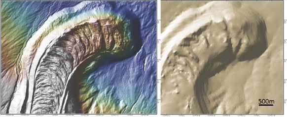
High-resolution airborne LiDAR land elevation data sets with a horizontal grid spacing of 1/9th arc second (~3m) has been added to GeoMapApp for the Cascadia margin volcanoes Mount Rainier, Mount St. Helens, Mount Hood, Three Sisters, Mount Bachelor, Crater Lake, and Mount Shasta. As shown in Fig.2, the LiDAR data provides unprecedented map detail for these volcanic regions. For the marine Cascadia component, Paul Johnson contributed multibeam swath bathymetry data from 2005 cruise TN177 which surveyed the shelf break and canyon area offshore Grays Harbor, WA.
ENAM
Continuing the USGS Extended Continental Shelf survey of the ENAM margin, Deb Hutchinson, Nate Miller, and Warren Wood conducted a 2-D multi-channel seismic reflection survey aboard R/V Langseth, MGL1506, in April 2015. That was followed by MGL1510, a community-based, open access 3-D seismic survey of the New Jersey margin in which PIs Greg Mountain, Craig Fulthorpe, Mladen Nedimovic, and Jamie Austin mapped the stratigraphic detail of shallow depositional systems as part of their study on facies and sea-level change. Field information for both expeditions is available through the Portal.
Experimental
The Portal now provides links to Kyle Straub’s GeoPRISMS sediment tank modelling experiments related to the stratigraphic architecture and geomorphological dynamics of passive margins.
GeoMapApp – version 3.6.0 of GeoMapApp was released. The new DataLayers menu consolidates the wide range of built-in global, regional, and local geoscience data sets that were originally listed under the Basemaps and Datasets menus in earlier versions of GeoMapApp. The consolidation allows the DataLayers menu to be structured more intuitively and managed more efficiently. The many built-in data sets are now arranged in the following categories that were chosen to reflect big-picture geoscience fields and themes.
For example, the new Geophysics menu includes data sets ranging from lithospheric plate deformation, earthquake catalogues, gravity and magnetics anomalies, to heat flow data; and, the Geology category includes geological maps and interpretations, volcano catalogues, and seafloor characteristics. LiDAR data shown in Fig. 2 was also added to GeoMapApp.
The Session Manager (Save Session) has been enhanced and offers a basic ability to store, share, and re-use an instance of a GeoMapApp session. The captured information is stored as a small file that can be shared with colleagues and students. A saved session could be shared with a class to allow every student to open GeoMapApp at exactly the same starting point with the same data layers loaded and the same area displayed. When using GeoMapApp to generate a figure for publication, storing the session could be useful for its later reuse.


GeoPRISMS Data Portal Tools and Other Relevant IEDA Resources
Search For Data – The customised GeoPRISMS search tool provides a quick way to find GeoPRISMS data using parameters such as keyword, NSF award number, publications, and geographical extent.
Data Management Plan tool – generates a data management plan for your NSF proposal. The on-line form can be quickly filled in, printed in PDF format and attached to a proposal. PIs can use an old plan as a template to create a new plan. We also have developed a tool to help PIs show compliance with NSF data policies.
GeoPRISMS Bibliography – with more than 1,120 citations, many tied to data sets. The references can be searched by primary site, paper title, author, year, and journal. The lists of publications can be exported to EndNote™. Submit your papers for inclusion in the bibliography – just the DOI is needed!
Contribute Data – Web submission tools support PI contributions of geophysical, geochemical, and sample data. File formats include grids, tables, spreadsheets, and shapefiles. Once registered within the IEDA systems, the data sets become available to the broader community immediately or may be placed on restricted hold. Additionally, PIs can choose to have a DOI assigned to each submitted data set, allowing it to become part of the formal, citable scientific record.
