The GeoPRISMS data portal was launched in 2011 as a new portal of the MGDS database. For the GeoPRISMS primary sites, the portal is populated with information and links to a range of new and existing high-priority data sets.
Since the last newsletter report, information on field programs of interest to the GeoPRISMS community has been added to the data portal and to GeoMapApp, as highlighted below. In addition, the database group participated in the GeoPRISMS-EarthScope Cascadia science meeting, holding a workshop to help increase awareness of database resources.
Alaska-Aleutians
Via GeoMapApp, instrument location information for the 1999-2001 BEAAR (Broadband Experiment Across the Alaska Range, PIs Geoff Abers, Doug Christensen and Roger Hansen) and the 2006-2009 MOOS (Multidisciplinary Observations of Onshore Subduction, PIs Geoff Abers, Doug Christensen and Jeff Freymueller) seismic experiments are now available as shown in Figure 1.
Cascadia
Information was added to the portal for a number of recent field programs. For a two-ship imaging experiment on the Juan de Fuca plate, Suzanne Carbotte’s team onboard Langseth cruise MGL1211 shot 2-D MCS lines and shot to onshore seismometers operated by groups led by Geoff Abers, Anne Trehu and Helene Carton. They also shot to OBSs that were tended by a team led by Pablo Canales onboard R/V Oceanus. That survey was followed by the first open-access community experiment to be run on Langseth: NSF-RAPID-funded cruise MGL1212. Under the direction of chief scientists Steve Holbrook, Katie Keranen and Graham Kent, 2-D MCS lines were acquired on the Cascadia margin to help refine the future location of a 3-D seismic survey (Fig. 2). Cascadia Initiative Year 2 OBS operations have continued throughout the summer. Starting with Oceanus cruise OC1205A led by John Collins, 23 OBSs were recovered. In July 2012, chief scientists Maya Tolstoy and Richard Allen oversaw the deployment of half a dozen trawl-resistant OBSs and the recovery of two dozen Year 1 OBSs. The short 4th cruise of Year 2, OC1208A, under Emilie Hooft and William Wilcock’s leadership was used to deploy 25 OBSs. Information and links to data for Tim Melbourne’s Pacific Northwest Geodetic Array (PANGA) is also provided through the GeoPRISMS data portal.
ENAM
Law of the Sea bathymetric survey RB1202 (chief scientists Armstrong, Calder, Gardner, and Johnson, all at UNH) imaged the Cape Fear Slide and Hatteras Transverse Canyon (Fig. 3).
-
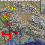
- Figure 1. MOOS (red circles) and BEAAR (yellow triangles) instrument locations overlain on the GeoMapApp base map which comprises the high-resolution USGS NED land elevations model with the Global Multi-Resolution Topography synthesis of the oceans. When an instrument location is selected on the map, its record is highlighted in a table. The URL takes users to an IRIS station information web page.
-
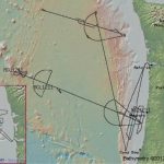
- igure 2. Main map: MGL1211 cruise track line over the Juan de Fuca plate and Cascadia margin. The red rectangle displays the area covered by the inset map (left) showing MGL1212 survey lines.
-
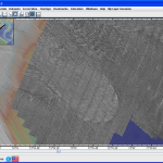
- Figure 3. Backscatter data from July 2012 cruise RB1202 clearly distinguishes the lobate tongue of the Cape Fear slide carbonate debris (center of map) from the choppy acoustic signal returned from the siliciclastic sediment of the Hatteras system depositional lobe lying directly to the north (top center of map).The backscatter data is overlain on gridded high-resolution Law of the Sea bathymetry data collected over recent years and seen in the western portion of the map.
GeoPRISMS Data Portal Tools and Resources
Search For Data Customised GeoPRISMS search. Search by key word, NSF award number, data sets related to publications, or within a geographical box.
Data Management Plan tool – Generate a data management plan for your NSF proposal – the on-line form can be quickly filled in, printed in PDF format and attached to a proposal. We also have developed a tool to help PIs show compliance with NSF data policies.
GeoPRISMS Bibliography – This integrated, searchable GeoPRISMS bibliography currently contains more than 380 references related to GeoPRISMS science, with papers tied to associated data sets. The lists of publications can be exported to EndNote™.
GeoMapApp and Virtual Ocean GeoMapApp – a free map-based data exploration and visualisation tool, currently stands at version 3.3.0. generate custom maps. Explore built-in data sets and import your own data tables, spreadsheets, grids, images and shapefiles. Recent enhancements include an updated Petrological Database (PetDB) portal; an updated Digital Seismic Reflection portal that includes access to MCS and SCS profiles collected by USGS; the ability to specify a start and end location for the profiling tool; and, capability to use different symbols to plot built-in and imported tabular data sets. Multimedia audio-visual tutorials are available on the GeoMapApp web page and on YouTube™. Virtual Ocean, version 2.5.6, offers GeoMapApp-style capabilities in 3-D.
GeoPRISMS MediaBank – Access GeoPRISMS-related images including photos from field expeditions. Please send compelling images to be considered for the gallery!