Conveners: Larry Brown, Judith Hubbard, Marianne Karplus, Simon Klemperer, Hiroshi Sato
7:20 | Discussion on key scientific questions – Simon Klemperer
7:40 | Break
7:50 | Session II: Seismic hazards and mitigation in the Himalayan region – Judith Hubbard
8:05 | Discussion on seismicity and seismic hazard – Marianne Karplus
8:30 | Session III: Organizational strategies for future action – Greg Moore
8:45 | Final discussion – Judith Hubbard
9:00 | End for formal session
The Mw 7.8 Gorkha, Nepal, earthquake that occurred on April 25 of this year was a dramatic reminder that great earthquakes are not restricted to the large seismogenic zones associated with subduction of oceanic lithosphere. The latter have been the foci of a number of major geoscience initiatives over the past several decades, most notably the MARGINS SEIZE program, as well as the host of several recent great earthquakes, including the Mw 9.0 Tohoku earthquake of 2011 and the Mw 8.8 earthquake of Maule, Chile in 2010. The Himalayas seismogenic zone is in many respects the continental counterpart to these largely marine systems. As such it not only represents important scientific and societal issues in its own right, it constitutes a reference for evaluating general models of the earthquake cycle derived from the studies of the oceanic subduction systems.
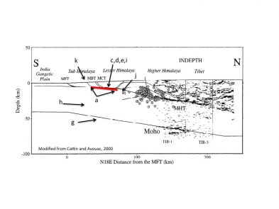
The Himalayan seismogenic zone shares with its oceanic counterparts a number of fundamental questions with respect to the accumulation of strain and its release by major earthquakes. These include:
a) What controls the updip and downdip limits of rupture?
b) What controls the lateral segmentation of rupture zones (and hence magnitude)?
c) What is the role of fluids in facilitating slip and or rupture?
d) What nucleates rupture (e..g. asperities?)?
e) What physical properties can be monitored as precursors to future events?
f) How effectively can the radiation pattern of future events be modeled?
However the underthrusting of continental, as opposed to oceanic, lithosphere in the Himalayas frames these questions in a very different context:
g) How does the greater thickness and weaker rheology of continental crust/lithosphere affect locking of the seismogenic zone?
h) How does the different thermal structure of continental vs oceanic crust affect earthquake geodynamics?
i) Are fluids a significant factor in intercontinental thrusting?
j) How does the basement morphology of underthrust continental crust affect locking/creep, and how does it differ from the oceanic case?
k) What is the significance of blind splay faulting in accommodating slip?
l) Do lithologic contrasts juxtaposed across the continental seismogenic zone play a role in the rheological behavior of the SZ in the same manner as proposed for the ocean SZ?
m) How can a better understanding of Himalayan rupture be translated into more cost effective preparations for the next major event in this region?
Major differences in the study of the continental vs oceanic seismogenic zone also relate to the opportunities for new geological observations. In contrast to the study of submarine seismogenic zones which lie beneath many klimoters of water, Himalaya structures are open to:
a) direct geological observation via field mapping
b) dense and wide aperture monitoring of surface strain via GPS and INSAR
c) extensive sampling of geofluids via surface flows and shallow drill holes
d) cost effective deployment of long term geophysical arrays (e.g. seismic and MT) designed to detect subtle variations if physical properties within the seismogenic zone, and ultimately,
e) a fixed platform for deep drilling of past and future rupture zones
The only logistical advantage of the marine environment for the study of the seismogenic zone is the relatively lower cost of multichannel seismic reflection profiling that forms the backbone of such initiatives. However, that advantage may be offset in part by new recording technologies for land acquisition, especially for 3D surveys. Moreover, in some respects the “fixed” land environment is more amenable for the design of cost-effective time lapse geophysical monitoring.
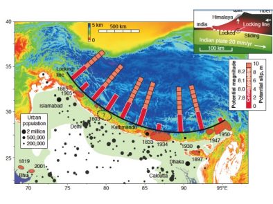
It remains to be established whether the Himalayan seismogenic zone has the potential for earthquakes of the greatest magnitudes (e.g. 9.0+). However, there is no question that future ruptures in this system represent a serious threat to major population centers (megacities) in the India subcontinent. For this reason alone the HSZ is deserving of a major effort exploiting the new generation of geophysical and geological tools.
International Imperative
Any Himalayan Seismogenic Zone effort will be international by the very nature of the target. Certainly one on the scale envisioned here will require the substantial resources that only a multinational consortium can rally. It must also respect the interests of the scientists and authorities of the countries most affected, especially Nepal, Bhutan and India, and should take advantage of special scientific assets in the regional. The workshop being proposed is a first step toward identifying and organizing these diverse interests and resources.
Interdisciplinary Foci
Experience with the MARGINS SEIZE initiative as well as numerous individual investigator efforts have clearly demonstrated the desirability of integrating results from multiple approaches. The most obvious components include: multichannel seismic reflection detailing of structure, wide-angle seismic measurements of physical properties (e.g. bulk P and S wave velocity, reflector AVO, attenuation, anisotropy), passive seismic measurement of gross structure and physical properties (e.g. anisotropy), MT measurements of conductivity, laboratory measurements of relevant physical properties of local samples, field geological mapping of relevant surface structure and lithology, monitoring of ground water geochemistry, mapping and monitoring of heat flow, GPS and INSAR monitoring of surface strain accumulation and geodynamic modeling of realistic crustal structure. A particularly exciting prospect is time lapse seismic /MT imaging of subtle changes in physical properties within previous and potential future rupture zones.
GeoPRISMS
Virtually all of the issues outlined above relate explicitly to the goals of GeoPRISMS as summarized in its Mission Statement: GeoPRISMS investigates the coupled geodynamics, earth surface processes, and climate interactions that build and modify continental margins over a wide range of timescales (from s to My), and across the shoreline. GeoPRISMS research has applications to margin evolution and dynamics, construction of stratigraphic architecture, accumulation of economic resources, and associated geologic hazards and environmental management. The Himalayas are the global icon of the end member evolution of convergent continental margins in general. Understanding seismogenesis in this setting is not only critical to evaluating seismic hazards resulting from continent-continent collision, but the processes that control major earthquake ruptures in oceanic subduction zones as well. Moreover the “shoreline” here is exposed to direct geological examination in a way that contemporary marine “proto-equivalents” are not.
The workshop will be open to all interested individuals. Researchers at early stages in their career are especially encouraged to attend.


