Thursday, December 8, 2011, 11:30am – 1:30pm
Conveners: The GeoPRISMS Office on behalf of the ENAM Community
11:30 | Introduction and background
11:30 | Motivation, objectives and approach – Harm van Avendonk & Beatrice Magnani
11:40 | Summary of Fall ENAM workshop and selected focus areas – Vadim Levin
11:50 | KProposed USGS Extended Continental Shelf surveys – Daniel Brothers, Uri ten Brink
12:00 | Potential industry partnerships – Harm van Avendonk
12:10 | What is a community experiment – Donna Shillington
- Data processing, format, and access | Donna Shillington, Beatrice Magnani
12:20 | Discussion
12:30PM | Possible Experiment Scenarios – N. Miller, Daniel Brothers, J. Kluesner
End-Member Models
- One high-priority, margin normal, wide-angle onshore-offshore transect
- Multiple onshore-offshore wide-angle surveys (spacing, orientation)
Intermediate and alternate models, e.g.,
- Comprehensive coverage, shallow MCS survey
- Several wide-angle transects
Discussion
1:00 PM | Moving Forward with Community Involvement
- Logistical constraints (ship scheduling, instrument pools, permitting)
- Offshore logistics – Donna Shillington & Harm van Avendonk
- Onshore logistics – Beatrice Magnani
Discussion – Making it happen
- Who will be the “heroes”
- Preparing and submitting a community proposal to NSF
- Building an industry consortium
- Communication and participation (e.g., on-line forum)
Wrap-up
The imminent arrival of the EarthScope transportable array (TA) and selection of the Eastern North American Margin (ENAM) as a GeoPRISMS primary site, are defining exciting new research opportunities along this margin. In addition, the USGS is responsible for coordinating the collection of seismic data along the eastern seaboard as part of the US Extended Continental Shelf Project under the UN Convention on the Law of the Sea. Tentatively, USGS surveys in the ENAM area will take place in 2013 using the R/V Langseth seismic vessel, providing potential opportunities for piggy-back experiments.
This convergence of interest in ENAM, and the presence of the R/V Langseth in Atlantic waters, offers a unique opportunity to conduct a community seismic experiment along the ENAM, benefiting a large number of researchers, especially students and early-career investigators. Improved seismic imaging of the margin, both shallow and deep, onshore and off, would address a wide range of GeoPRISMS and related research objectives. It can yield a backbone dataset for studying the deep structure of the margin, its structural and stratigraphic architecture, ongoing geodynamic processes, economic potential, and many other aspects.
If you would like to learn more, participate in, and/or contribute to planning discussions about the scope and objectives of such a community seismic experiment, please register to attend the luncheon. The luncheon discussion will include:
- Identifying and prioritizing scientific objectives for an ENAM seismic experiment
- Possible end-member survey scenarios (e.g., minimum cost vs. comprehensive coverage)
- How to engage and coordinate with potential partners (USGS, Industry)
- Data access requirements and expectations (and schedules)
- How to prepare and submit a community proposal

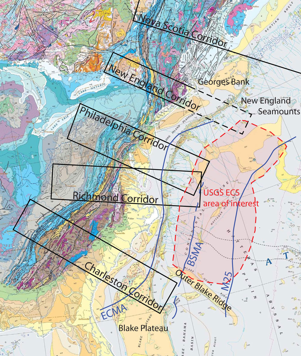
Figure 1: Map of Discovery Corridors in ENAM focus area. The red shaded area is the target of the USGS seismic program on the U.S. Extended Continental Shelf. ECMA = East Coast Magnetic Anomaly, BSMA = Blake Spur Magnetic Anomaly.
U.S. Earth Scientists Prepare for a Community Seismic Experiment at the ENAM Primary Site
2011 AGU Fall Meeting San Francisco, CA
1University of Texas at Austin, 2University of Memphis
Eastern North America (ENAM) was chosen as a GeoPRISMS Rift Initiation and Evolution primary site because it represents a mature rifted continental margin in which the entire record of continental break-up and rifting is preserved. The rifting history along ENAM is well recorded in basin stratigraphy and the underlying crustal structure, although subsidence, sediment transport and fluid flow are presently the dominant geological processes along the margin. The study of old rifted margins is often challenged by a thick cover of sediments, which masks much of the deep crustal structure. This is also true for ENAM; however, over the next few years, unprecedented opportunities exist to carry out focused geophysical studies, revealing both shallow and deep structures of ENAM in greater detail.
The convergence of two activities along ENAM serves to frame data-gathering opportunities. In 2013, the EarthScope Transportable Array (TA) will arrive in ENAM, and the USGS is planning a marine seismic reflection and a limited refraction study of the Extended Continental Shelf (ECS) along ENAM onboard the seismic vessel R/V Marcus Langseth, possibly as early as 2014. In addition, there is renewed interest from energy companies in the exploration of ENAM . At the joint Earthscope-GeoPRISMS Science Workshop on Eastern North America, held at Lehigh University in October 2011, discussions among various academic, government and industry scientists led to the suggestion that a community active-source seismic experiment could improve our understanding of the deep structure and evolution of ENAM, and make the best use of existing resources and upcoming opportunities. The planned USGS active-source seismic operations over the ECS provide part of the immediate impetus for such an experiment; however, the possibility exists to extend some of the proposed USGS profiles landward to image deep margin structures and obtain important seismic velocity constraints. Given the limited mission of USGS ECS surveys, funding to extend these profiles and record air-gun shots on-land must come from NSF, possibly with some industry sponsorship.
A GeoPRISMS-sponsored luncheon was held in San Francisco on December 8, 2011, during the AGU Fall Meeting. About 30 scientists met to discuss further the conceptual framework of a community proposal for an ENAM active-source seismic experiment. Several scenarios were discussed, from minimum-cost to comprehensive coverage. The latter could include onshore-offshore operations, e.g., air-gun shots from the R/V Marcus Langseth recorded not only by its 8-km-long multichannel seismic streamer, but also by co-linear OBSs and by EarthScope Flexible Array seismometers, deployed along on-land extensions of selected marine seismic transects. In addition, land-based shots along these transects could be recorded by Flexible Array seismometers as well as by OBSs, providing reverse coverage. Additional PI-driven piggyback deployments offshore and onshore could be designed to take further advantage of the community seismic effort. The consensus at the luncheon was that such a joint seismic experiment is feasible and opportune; however, the timing may depend on the final schedule for the USGS seismic program.
The GeoPRISMS ENAM primary site spans much of the U.S. and Canadian Atlantic margins, from Charleston to Nova Scotia. However, budgetary and logistical constraints require that the target area of a community seismic experiment be much smaller. The area of interest for the planned USGS ECS seismic study lies between the Outer Blake Ridge offshore South Carolina in the south and Cape Cod to the north (Figure 1). Within this region, the planned ECS seismic survey consists of profiles spaced 60 nautical miles apart, spanning the interval from the continental shelf break to the 200 nautical mile limit. To meet GeoPRISMS objectives, some of these profiles would be extended landward across the shelf, and onshore, where air-gun shots would be recorded by land stations.
At the EarthScope-GeoPRISMS Science Workshop at Lehigh, participants identified a few major corridors where dense data acquisition would benefit integrated studies of rifted margin processes (Figure 1). The “Philadelphia” and “Richmond” corridors exhibit pronounced along-strike structural variations in the Appalachians; thus, seismic transects that cross the shoreline in these two areas may yield insights into the role of inherited orogenic structure on the development of rift half-grabens, such as the Culpeper and Hartford basins, and the nature of syn-rift magmatic wedges that define the continent-ocean transition offshore. To the south, a transect in the vicinity of Charleston, SC, would image the transition between the Carolina Trough and the Blake Plateau, clarifying the structure and origin of basement in this area. In addition, the gas hydrate province of Blake Ridge is an important site for the assessment of geohazards on the continental slope. Comparisons of the deep-seismic structures along the northern and southern corridors would provide a view of regional differences in extension and magmatism during the opening of the Atlantic, helping to explain the linkages between these processes.
To have a true community experiment, broad participation from the U.S. scientific community is necessary. Researchers interested in participating in an ENAM community seismic experiment are invited to help with the (a) design of the active-source seismic data acquisition plan, (b) proposal writing, and (c) staffing of the data acquisition teams on-land and offshore. The involvement of graduate students and postdocs in this effort is very important, as these early-career scientists represent the core of the future GeoPRISMS and EarthScope communities. In the sprit of community science, we envision rapid data release and open data access following the experiment, enabling many members of the scientific community to participate in seismic data analysis and interpretation. Science proposals to use the seismic data could be submitted to NSF once the data are collected.
Although funding of the USGS seismic study of the ECS is currently uncertain, this field program is tentatively being planned for 2014. To create a successful partnership with the USGS in 2014, collaborative proposals must be submitted to the NSF GeoPRISMS and EarthScope Programs solicitations in 2012, on July 2nd and July 16th, respectively. Over the next few months, we hope to engage our colleagues in discussions about ENAM science priorities, and we welcome insights and contributions to the ENAM community seismic experiment proposal. Consider contributing through the GeoPRISMS forum site or by contacting us directly.

 Part I – The Eastern Branch Focus Site
