ENAM science advances: Progress and outlook


  Westin Canal Place
100 Rue Iberville, New Orleans, LA, 70130
Crescent Ballroom – 11th Floor

Sunday December 10, 2017, 8:30 AM – 1:00 PM

Conveners: Colton Lynner and Zach Eilon

 icon-file-text-o Participant list

 icon-file-text-o Meeting agenda

AgendaMeeting objectivesMeeting report

08:30  | Welcome and Introductions  – GeoPRISMS Chair Demian Saffer and Colton Lynner

Appalachian Mountains

08:45 Keynote | The Appalachians – Lara Wagner

09:05 – 09:25 | Pop-ups by early career participants

Characterizing the Southeastern Appalachian Margin via integrated potential field and structural modeling– Patrick Duff

Insights on magmatic addition beneath the Atlantic Coastal Plain from crustal refraction seismic data – Lindsay Worthington

Localized rifting and magmatism from the crustal velocity structure of the Southeastern United States – Rachel Marzen

Correlation of three-dimensional variations of seismic Moho with tectonic terranes in eastern North America – Cong Li

09:30  Keynote | Surprising magnetotelluric results from the Eastern North American Margin – Ben Murphy

09:50 | Discussion

10:25 | Break

Offshore Margin

10:40 Keynote | Offshore ENAM margin Final stages of continental breakup and early seafloor spreading history – Anne Bécel

11:00 – 11:20 |  Pop-ups by early career participants

Offshore Margin – Brandon Shuck

Refining the formation and early evolution of the Eastern North American Margin – John Greene

How fast were the ECMA SDRs emplaced? – Joshua “Bud” Davis

Expanded mid-Atlantic deep water allostratigraphy – James Gibson

11:20 | Discussion

Margin-wide Synthesis

11:50 Keynote | Margin-wide synthesis  – Roger Buck

12:10 – 12:20 | Pop-ups by early career participants

Explore the Uplifting Mechanism of the Adirondack Mountains – Xiaotao Yang

Lithospheric structure of the Southeastern US – Erin Cunningham

12:20 | Discussion

12:45 | Conclusion – Zach Eilon

The Eastern North American Margin (ENAM) GeoPRISMS focus site is a type locale for the terminal stage in the evolution of a passive rift margin. New observations, as well as reevaluations of legacy datasets, hold promise for improving our understanding of the evolution, history, and present-day topography of the Appalachian Mountains, anomalous volcanism along the margin, crustal and lithospheric structures as determined through multiple data types, the transition from ocean to continent and possible diachronous breakup, and dynamic processes in the mantle. The particular strength of the GeoPRISMS community lies in its combination of expertise in diverse fields (e.g. seismology, magnetotellurics, geology, structure and surface processes, geochemistry, and dynamical modeling) to address large outstanding problems. A crucial aspect to this community approach is the maintenance of periodic synthesis meetings that provide a multidisciplinary forum for comparison and integration of novel research findings. This mini-workshop will be held at the Westin Canal Place (http://www.westinneworleanscanalplace.com) on Sunday, December 10th, prior to the Fall 2017 AGU meeting, and will focus on new results from investigations of the ENAM at a variety of scales, with a focus on research highlights and outstanding research questions that demand integration of multiple perspectives. We have prioritized early-career (grad student + post-doc) contributions and ample discussion time to emphasise a forward-looking approach to this community endeavour.

ENAM science advances: progress and outlook

Sunday December 10, 2017 | AGU Fall Meeting 2017 | New Orleans, LA

Organizers: Zachary Eilon1 and Colton Lynner2

1UC Santa Barbara, 2U Arizona

The Eastern North American Margin (ENAM) science advances: progress and outlook mini-workshop was held on Sunday morning immediately preceding the 2017 AGU Fall Conference. This workshop was designed to provide an opportunity for community presentation and discussion of new and future work on the Eastern North American Margin. The timing of the workshop, approximately two years following the conclusion of the ENAM Community Seismic Experiment (CSE), was ideal for showcasing mature research projects that span the entirety of the margin, from the Appalachian Mountains to the offshore region. The workshop featured products of the amphibious broadband seismic and multi-channel seismic (MCS) data as well as the integration of EarthScope Transportable Array with the ENAM-CSE.

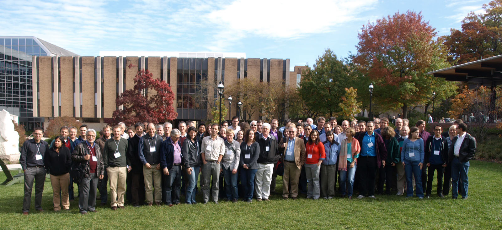
This workshop had 34 participants in total, including 20 (59%) early-career scientists (graduate students and post-docs) – this attendance despite weather related travel difficulties for many attendees. In order to promote the integration of multiple scientific perspectives and sub-disciplines that encompass the ENAM, the mini-workshop was organized thematically by geographic region. Sessions were divided between the Appalachian Mountains and the Onshore Margin, the Offshore Margin, and Margin-Wide Synthesis, ordered sequentially for a geographic and thematic progression. The format of the workshop was split approximately evenly between keynote presentations (20 minutes each), pop-up talks (5 minutes each) and discussion time. Keynote speakers were asked to give an overview of the active research topics and outstanding questions in each region. Pop-up talks were selected from graduate-students and early career researchers who applied to speak at the mini-workshop. This format allowed 15 separate presenters to highlight their recent research products, while also building in opportunities for participants to talk through consistencies and incongruences between cutting-edge results.

Here, we summarize the main conclusions of the presentations and discussions (for speaker affiliations, see workshop schedule, below):

Appalachians and Onshore Margin: 

Lara Wagner provided a thorough tectonic and literature background for ENAM research; she emphasized that for a “passive” margin, ENAM looks surprisingly active, with ongoing seismicity, Eocene volcanics near Harrisonburg, and steep relief. Lara noted that variations in the Appalachian orogen along-strike may reflect pre-existing Grenville structure underlying the present margin. Her surface wave models reveal a localized low-velocity upper mantle anomaly precisely co-incident with the Eocene volcanics, posited as a lithospheric hole/drip. In addition, she images a slow anomaly resembling delamination beneath the Cape Fear Arch and distinct lithospheric structure across the Grenville front that indicates significant lithosphere-asthenosphere (LAB) boundary topography well inboard of the ocean-continent transition.

Patrick Duff used magnetic and gravity modeling along with legacy seismic datasets to argue for ~370km of shortening during Appalachian orogenies. He showed that lower-crustal variability was not necessarily needed in order to account for the gravity signal. His results suggest that the Carolina Terrane does not extend the entire depth of the crust and that the Grenville basement extends farther east than previously thought.

Lindsay Worthington showed new results from the on-land component of the ENAM-CSE active source experiment. Her results show a surprisingly simple lower-crustal structure beneath the onshore portion of the margin, with elevated supra-Moho velocities perhaps indicating crustal underplating related to the initial formation of the ENAM on one of the two lines. High crustal velocities seem to be only present on the southern line, suggesting high variability in crustal structure and underplating.

Rachel Marzen’s work on the SUGAR lines (South Georgia Basin) crosses Mesozoic rift basins and multiple potential suture zones between accreted terranes. They observed high Vp and Vs within the Inner Piedmont and Carolina accreted terranes that are underlain by a low velocity zone at ~5 km depth. Differences in the basin structure, lower crustal velocities, and crustal thickness between the two lines reflect varying extension and magmatism despite their extremely close proximity.

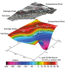
Cong Li’s P-s receiver function study (ably presented in his absence by Xiaotao Yang) indicates good correlation between Bouger gravity and Moho topography in New England, suggesting that Mesozoic terrane boundaries still control today’s Moho gradients with significant offsets in Moho topography associated with the northern Appalachians.

Ben Murphy presented magneto-telluric (MT) evidence for a deep, electrically-resistive body beneath the piedmont, spanning the region from Georgia to Virginia and extending from just east of the mountain belt to the coastline. He argued, based on extensive sensitivity testing, that this feature must be deep (up to 300 km) and so strongly resistive that it must be dry and colder than ~1200˚C; this MT signature is comparable to that of a craton. Ben also sees conductors beneath the Appalachians, and arguably beneath the Harrisburg anomaly.

Much of the discussion for this session focused on the discrepant tomographic and MT results beneath the coastal plain. Whereas tomographic images clearly delineate a thin piedmont seismic lithosphere (in contrast to thicker lithosphere inboard of the Grenville front), the MT data indicates almost the exact opposite, with thick resistors outboard of the orogen. There was also significant discussion regarding the differences between lower crustal active source lines (both on a small scale, such as the differences between the two ENAM-CSE onshore active source lines, and on a margin-wide scale, such as differences in Moho topography or variability between terranes and rifting contexts). There appear to be variation in the factors controlling Moho topography, crustal underplating, and lower-crustal structure both along strike and orthogonal to the passive margin.

This was the first of a series of discussions related to the theme of lateral heterogeneity and observational discrepancies along the ENAM. The discrepancy between MT and seismic tomographic results, along with our understanding of lithospheric structure in a passive margin, suggests there is something chemically or thermally unique about the onshore portion of the margin. We discussed a variety of mechanisms, including hydration state, thermal anomalies, seismic anisotropy, magmatic underplating, etc., that could account for both the thin seismically-inferred lithosphere and the thick lithosphere indicated by MT data. The group’s consensus was that more work is needed to settle the debate. In a similar vein, the lateral crustal heterogeneities indicated by receiver-function, active source, and modeling data require highly variable structural controls in order to account for the difference in observations over short lateral scales, and these may provide insight into a spectrum of mechanisms involved in margin formation along strike. We concluded this section (as with the entire workshop) with the questions: 1) Is there such a thing as a type locale for a magmatic (or really any type) of passive margin? 2) What is the necessary scale of an experiment to capture all of the complexities and variability of a passive margin? 3) What does the lithosphere-asthenosphere boundary look like across the ENAM?

Offshore Margin:

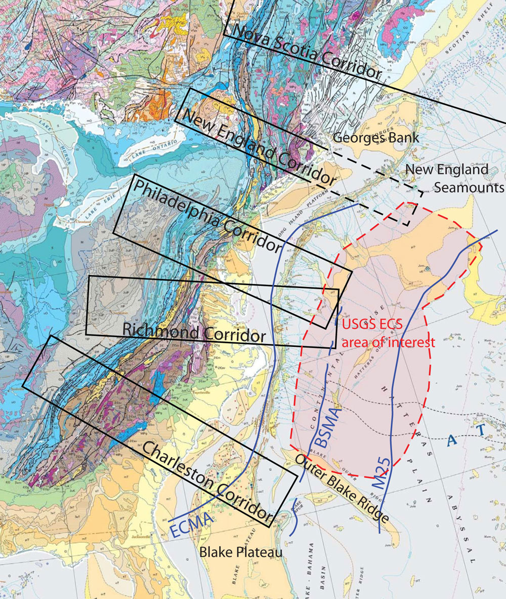
Anne Becel presented high quality MCS and wide-angle refraction results spanning the entire continental margin. Among the notable features were a continuously map-able Moho, erosional unconformities demarcating rift-related sedimentation, well-captured seaward-dipping reflectors (SDRs) and thick ocean-continent transitional crust in the region of the East Coast Magnetic Anomaly (EMCA). Modelling indicates that the ECMA is produced by a 10-15 km thick packet of SDRs with high magnetic susceptibility. Anne argued that rough basement topography in transitional crust, including 10-20 km tilted blocks, is an indication that early seafloor spreading was very slow. She shows that the Blake Spur Magnetic Anomaly (BSMA) coincides with thickening extrusive basalts and high-velocity lower crust, both attributable to hotter potential temperatures (Tp) at the time of formation.

Brandon Shuck’s OBS results were in strong agreement with Anne’s findings. He used petrological modelling to argue that thickened Blake Spur Magnetic Anomaly (BSMA) crust implies Tp ~ 1450˚C, positing that heterogeneity in source mantle fertility could explain along-strike crustal thickness variations. Noting that the BSMA has no African margin counterpart, Brandon suggested that this feature represents a melt pulse upon final lithospheric breakup.

John Green presented refined magnetic anomaly correlations throughout the offshore ENAM and assigned updated ages and chron numbers to M0-M25 and eight pre-M25 anomalies, identifying five correlated magnetic anomalies between the East Coast Magnetic Anomaly (ECMA) and the BSMA. His results suggest that, if the BSMA source is oceanic crust, the BSMA may have formed ~168.5 Ma and represent the initiation of oceanic crust formation. His results also suggest asymmetric crustal accretion indicating possible ridge re-orientation early in Atlantic opening, potentially involving a ridge jump.

Joshua Davis presented his modelling of ECMA SDR emplacement, seeking to explain the paradoxical observations that this feature is a single (positive) magnetic anomaly – implying extraordinary SDR emplacement rates – with no negative analogue. He argued that this feature was not produced within the span of a single magnetic reversal, but is in fact an induced anomaly (explaining the absence of similar negative anomalies) that may have formed slowly (5-20 My).

James Gibson expanded deep water allostratigraphy observations to show that bottom-current erosion rates vary along the margin. Fast erosion and large slope failures in the south contrast with well-developed fan structures to the north; deep currents may have controlled transport of slope sediments to the deep sea.

At the conclusion of the Offshore Margin session, discussions focused primarily on the location of initiation of oceanic crustal formation and on the best ways to assimilate offshore results with onshore data. Previous published studies have suggested the ECMA as the location of initial formation of oceanic material, but several pop-up talks presented results that indicate the BSMA is the site of initial crustal formation. BMSA rifting initiation seems to be a fairly robust result, coming from both seismic and magnetic data. This new conclusion alters the estimates of the extent of thinning and spreading of continental material along the margin. There may be far more highly attenuated continental material along that ENAM than previously thought. Merging offshore structural inferences to those made onshore remains a challenge facing the ENAM community, as applying uniform processing techniques to both datasets has yet to be widely achieved. Both regions show laterally variable structures and Moho topography. Connecting the site of rift initiation (either the ECMA or BSMA) to the inferred magmatic underplating and sea-ward dipping reflectors seen in both the offshore and onshore active-source data also remains an area of focus for the ENAM community. Placing the magmatic features of the margin in the context of oceanic crustal formation and highly attenuated continental crust represents an unprecedented opportunity to advance our understanding of intrusive structures in rifted margins, and may provide a tool with which to address the level of lateral variability in crustal structure across the ENAM.

Margin Overview:

Roger Buck gave an expansive overview of the large outstanding geodynamic questions in the context of rifts: Are plumes important for rift initiation? What role does pre-existing structure play? Roger discussed the rarity of a rift directly abutting a large orogenic province such as the Appalachians, and discussed implications of this juxtaposition. He focused on the chicken-egg problem of melting and rifting, as well as the possibility of using SDRs as a proxy for paleo-elastic thickness. He raised the possibility that Newark-series basins (which pre-date CAMP) represent a failed rift, emphasizing that with time, failed rifts can become stronger than the plate around them.

Xiaotao Yang showed results of his full-waveform ambient noise Vs tomography in the Adirondacks, where accreted terranes inboard of the Appalachian orogen are co-located with a Bouger gravity high. He showed localized low VS in the upper mantle in this region; when modeled, the associated density structure explains the high topography, perhaps related to edge-driven convection.

Erin Cunningham’s S-p and P-s receiver function common conversion point maps reveal crustal thickening beneath the eastern Tennessee seismic zone, after she has processed the data using a novel sediment removal filter technique.

The conclusion of the Margin Overview session served as both a discussion on the overall structures and processes associated with the ENAM and on mature passive margin formation worldwide. As one of the GeoPRISMS primary sites, inferences made at ENAM should be applied more broadly to advance our understanding of rifting processes. This lead to significant discussion as to whether such applications are justified, given all of the variability and discordant results observed along the margin. Even the most basic questions, such as: What is the Moho topography? What is the LAB structure? Where did rifting begin? Is there magmatic underplating beneath the margin? seem to have answers that strongly depend on the specific seismic lines, imaging techniques, and geophysical observables being used. Our final conclusion was that we have learned that ENAM is more complex and recently active than was previously appreciated, and that there may be no such a thing as a ‘type-locale’ for a passive margin. The ENAM community has a lot more discovery and discussion lying ahead as we reconcile the different observations and begin to unravel the controls on the variable nature of the margin.

2011 Planning Workshop for the ENAM Primary Site

October 27-29, 2011
Bethlehem, Pennsylvania

AnnouncementAgenda - Presentation archiveStudent SymposiumWhite Papersmore infoOutcomes

We are pleased to announce a joint workshop aimed at assembling the EarthScope and GeoPRISMS communities interested in the formative onshore and offshore geological, geophysical, and geodynamic processes of Eastern North America (ENAM). Our goal is to focus community effort and research approaches on crucial science targets with a national and international forum of scientists from universities, national labs, industry, federal, and state agencies. The transportable array of EarthScope arrives in the mid-Atlantic region in 2012-13 and GeoPRISMS recently selected ENAM as a primary site for Rift Initiation and Evolution (RIE) study.

The workshop will take as its starting point the ENAM RIE portion of the GeoPRISMS Science and Implementation Plans and the Earthscope Science Plan. The goals of the workshop will be to clarify common research objectives on the Grenville and Appalachian foundation, the structural, magmatic, and geodynamic setting of rift initiation, the rift-to-drift record preserved in sedimentary archives, the processes that characterize the evolution to a mature passive margin, and the active lithospheric and surficial processes that characterize the modern margin with an emphasis on possible feedbacks between surface and deep-Earth processes.

We anticipate funding to support ~75 researchers with a diversity of interests to participate in this workshop, both from the US and abroad, independent of past involvement in MARGINS, GeoPRISMS, or EarthScope research efforts. Post-docs, senior graduate students, and members of underrepresented groups are especially encouraged to apply. Applications should include a brief statement of interest and anticipated contribution to the workshop, and a short (1 to 2 page) CV.

The workshop will be held at the new STEPS facility at Lehigh University in Bethlehem, PA. The program will include a number of overview presentations of eastern North American geology, geophysics, and geodynamics, updates on current GeoPRISMS and Earthscope research projects, break-out sessions, and plenary discussions leading to conclusive decisions on collaborative science targets and research corridors.

Workshop Conveners:

Frank J. Pazzaglia, Lehigh University
Peter Flemings, University of Texas at Austin
Vadim Levin, Rutgers University
Dan Lizarralde, Woods Hole Oceanographic Institute
Basil Tikoff, University of Wisconsin
Martha Withjack, Rutgers University
Maggie Benoit, The College of New Jersey – Student Coordinator and Symposium Convener

Student Symposium | Wednesday, October 26

Day 1 | Thursday, October 27

7:00 Breakfast and registration.

Moderators: Frank Pazzaglia and Vadim Levin
8:00 Welcome, introductions and workshop goals | Frank Pazzaglia
8:15 NSF Program Director comments | C. Estabrook and Bil Haq
8:45 Review of EarthScope and GeoPRISMS science and implementation strategies and key decisions that must be made by each program
GeoPRISMS, research corridors, leveraging effort with industry and USGS, integration with EarthScope efforts |  3Mb – Juli Morgan

EarthScope, foundation of the 2004 workshop, key ENAM research topics, fate of TA and FA instruments and the possibility of an east coast observatory, extension of PBO to the east coast, integration with GeoPRISMS efforts |  3Mb – B. Tikoff

9:30 Plenary talks to introduce the ENAM region Session I
Modification of continental crust and lithosphere by continental rifting/breakup and by terrane accretion |  4Mb W. Thomas
Rifting and drifting in Eastern North America |  5Mb P. Olsen

Insights into rifting processes from variations in magmatism and structure along eastern North America |  9Mb D. Shillington

10:30 Working break, questions and discussion

11:00 Plenary talks to introduce the ENAM region session II
The lithosphere of the Appalachian orogen and the Atlantic passive margin: A seismological perspective |  2Mb K. Fischer
Analogue and numerical models that inform the rifting process  |  2MbJ. Armitage

Forward modeling of rift and passive margin formation; implications for South and Central Atlantic rifted margins | R. Huismans

12:00 Recent relevant EarthScope and GeoPRISMS projects
Southeastern suture of the Appalachian Mountain experiment (SESAME) project – broadband seismic experiment to study continental accretion and rifting |  6Mb L. Wagner

The Salton Seismic Project (SSIP): A joint GeoPRISMS + EarthScope + USGS investigation of Rift Initiation and Evolution |  5MbJ. Hole

12:40 Lunch

Moderators: Martha Withjack and Peter Flemings
1:30 Emerging hot topics (all of these are inter-related and important cross-program synergy building activities)
Late Cenozoic fluvial incision through the Susquehanna River drainage basin: A response to dynamic topography | S. Miller
Mantle dynamics and the recent evolution of the Eastern North American margin |  2Mb R. Moucha
EarthScope seismology |  3Mb M. Benoit

GeoPRISMS seismology |  3MbJ. Gaherty

2:10 Working break, questions and discussions. Includes an introduction to break-out process and objectives.

2:45 Breakout session I. Topical breakouts – introduction to key research ideas, participants are asked to rotate among two or more.
a. Orogenic processes – building the ENAM framework
b. Rifting processes – magmatism and the opening of the Atlantic Ocean
c. Post-rift processes – transformation to a passive margin

d. Neotectonics and surface processes – active processes on the passive margin

4:00 Emerging hot topics (all of these have important broader impacts)

Active deformation in Eastern North America |  3Mb M. Pritchard

Offshore active processes and hazards |  5MbP. Flemings

Diachronous evolution of syn-rift deformation and onset of seafloor spreading in the central Atlantic: Application of inverse continuum-based plate reconstruction methods |  7MbE. Kneller

Cenozoic history written in a passive continental margin: it’s there for the reading |  4Mb G. Mountain

5:00 Working break, questions and discussions

5:30 Breakout session II. Focus areas (e.g. Discovery Corridors) of the science topics; indentification of GeoPRISMS and EarthScope overlap

a. Orogenic processes – building the ENAM framework

b. Rifting processes – magmatism and the opening of the Atlantic Ocean

c. Post-rift processes – transformation to a passive margin

d. Neotectonics and surface processes – active processes on the passive margin

6:45 Board bus in for transport to the mountain-top campus

7:00 Dinner – Dinner presentation by Bob Sheridan on historic integrated approach to ENAM rifting and passive margin evolution

Moderator: Maggie Benoit

8:30 ENAM datasets and broad undergraduate involvement

GeoPRISMS and MARGINS data portal | A. Goodwillie

Potential for an ENAM REU |  3MbE. Johnson

9:30 Board bus for transport back to STEPS

Day 2 | Friday, October 28

7:00 Breakfast

Moderators: Dan Lizzarralde and Peter Flemings
8:00 Report from breakout sessions I and II and open discussion
9:30 Short presentation
Mineral, Virginia, earthquake illustrates seismicity of a passive-aggressive margin |  2MbS. Stein
Geodynamic modeling of the Canadian Margin | S. Ings
Other presentations

10:30 Working break and open discussion

11:00 Reports from aligned facilities and international partners
USGS: USGS work along the Atlantic Margin |  3MbD. Brothers
Implications of RIE basic science and models for an understanding of source and reservoir rocks on passive margin |  500KbG. Karner
Exploring pre-Cretaceous terranes and basins beneath the Atlantic Coastal Plain: Implications for rift-initiation and evolution |  2Mb W. Horton
New geoscience programs and initiatives for offshore Nova Scotia | D. Brown
European perspective on rifted margins | R. Huismans
Magma starved rifting: Galicia/Newfoundland breakup and initiation of  seafloor spreading |  1MbD. Sawyer

12:30 Questions and discussion

1:00 Lunch

Moderators: Basil Tikoff and Lori Summa
2:00 Breakout session I. Focus areas, discovery corridors, and synergy
Specific topics to be defined by the group discussion, possible including ES-GP synergy, fate of the TA in ENAM, and a possible PBO in ENAM. Rooms TBD.

6:30 Dinner

8:00 Poster session (Posters are up the entire meeting)

Day 3 | Saturday, October 29

All workshop participants are invited to attend a half-day field trip to examine Newark Rift Basin and its stratigraphy, sedimentology, and structure. The field trip will begin shortly following the close of the workshop.

Moderators: Frank Pazzaglia and Juli Morgan
8:00 Breakout session reports and open discussion

9:30 Student reports and perspectives

10:00 Break

10:30 Broader impacts

Panel discussion
EarthScope |  1Mb R. Arrowsmith and M. Fouch
GeoPRISMS |  1Mb J. Morgan and M. Benoit
DaVinci Science Center | D. Smith
IRIS |  4MbB. Woodward
R/V M.G. Langseth Facility |  4MbS.Higgins

11:00 Decision making

1. Where are the GeoPRISMS focus areas?
2. Where/how does GeoPRISMS leverage their efforts (industry and USGS)?
3. Are there GeoPRISMS thematic studies to be performed?
4. What are the highest priority EarthScope science targets?
5. What is the fate of the TA and FA once the scheduled deployment ends in 2015?
6. What would be the goals of an ENAM PBO?
7. What emerges as the best oppportunity for GeoPRISMS-EarthScope synergy?

12:30 Lunch (box lunch provided for field trip participants) and closure

1:30 Field trip to the Newark Basin exposures along the Delaware River

GeoPRISMS Student Symposium for the New Zealand Primary Site

  Cotton Building Room 217, Victoria University, Wellington, NZ
Sunday, April 14, 2013

The Graduate Student Symposium and Field Trip are designed to (1) introduce students to the objectives and opportunities of the EarthScope and GeoPRISMS Programs, (2) provide geologic and geophysical background about Eastern North America, both onshore and off (3) enable brief student presentations, as well as discussion and interaction in a comfortable setting, and (4) visit relevant geologic field sites in Pennsylvania. All symposium participants will enter the ENAM workshop with a rich background in the workshop topics and objectives, and an understanding of implementation strategies for moving the research horizon forward, as well as a strong cohort of colleagues and a greater voice in decision-making that will take place during the workshop.

8:00 Registration, Breakfast, and Welcome

9:00 Geologic, geophysical, geodynamic, and geomorphic background of ENAM – Appalachian, rift, and recent landscape evolution | Pazzaglia, Withjack, McKeon

10:20 Break

10:30 EarthScope and GeoPRISMS science strategies and rationale for ENAM workshop | Maggie Benoit

11:00 Student research presentations (poster and oral)

12:00 Field trip to Appalachian foreland, basin analysis reconstruction of the Appalachian range. (Box lunch provided) | Frank Pazzaglia

6:30 Student Dinner

6:00 Registration and Science workshop mixer. STEPS concourse A

 icon-download Download the compiled white papers

Kinematic reconstruction of the central US and conjugate northwest African margin | icon-file 300Kb Van Avendonk et al.

Deep-crustal seismic study of continental rifting in the Newfoundland Basin |  300KbVan Avendonk et al.

A central Appalachian EarthScope transect in Virginia: Examining upper mantle interaction with Paleozoic sutures, Eocene magmatism, and modern seimicity |  3MbBailey et al. 

Testing the lithospheric counterflow hypothesis |  1MbBeaumont et al.

Integrating lithospheric structure, mantle dynamics, and surface processes to investigate topographic and lithospheric evolution of the southeastern US continental margin |  600KbBenoit et al.

EarthScope in New England Appalachians: Structural inheritance and the long-term strenght of continental lithosphere |  500Kb Crespi et al.

Submarine groundwater discharge: linking the continental and oceanic hydropsheres |  500Kb Dugan et al.

Accretion of terranes and growth of continental crust along the southern margin of Laurentia during assembly of Pangea [and modifications by opening of the Gulf of Mexico] |  500Kb Dumond et al.

Slope failure control on margin morphology at the Cape Fear Slide |  500KbFlemings et al.

The role of magmatism in rifting: insight from the lithospheric mantle |  50KbGaherty et al.

GeoPRISMS Data Portal |  900Kb Goodwillie et al.

An REU site at James Madison University: understanding the Rift-to-Drift transition in Eastern North America and the North Atlantic |  200KbJohnson et al.

South Georgia Rift Basin: Rift Initiation and Evolution (RIE) Assessment through Controlled Source Seismology |  500Kb Knapp et al.

High-resolution marine magnetic anomaly data across the margin would delineate structures controlling lithospheric formation and rift localization |  1MbMiller et al.

Late Cenozoic stream incision in the Appalachian region |  300Kb Miller et al.

Evolution of continental crust through two Wilson cycles in ENAM |  700Kb Thomas et al.

Call for White Papers

The transportable array of EarthScope arrives in the eastern United States in 2012-13, and GeoPRISMS has identified the Eastern North America Margin (ENAM) as a primary site of the Rift Initiation and Evolution (RIE) initiative. Collectively, EarthScope and GeoPRISMS research spans the shoreline and, in doing so, provides an integrated framework for understanding the Appalachian mountain building processes, rift-initiation (including orogenic inheritance), and the evolution and structure of a mature continental margin. The associated broader impacts of natural hazards and assessment of the nation’s natural resources, including traditional and alternative sources of energy in the most densely populated part of the country, are fundamental to both programs.

The October 2011 Workshop has two main purposes. First, it will focus community effort and research approaches in the eastern United States, including identification of important EarthScope and GeoPRISMS RIE science targets. In particular, the GeoPRISMS RIE community could use the meeting to identify critical areas to target for focused research. Second, the workshop will establish research strategies that maximize EarthScope and GeoPRISMS synergies to address common research goals.

Scientists interested in participating in the development of the integrated science and implementation plan for ENAM are invited to submit White Papers. The White Papers will play an important role in the workshop outcomes, including guiding breakout discussions at the workshop, and they are thus an important mechanism for community input. White Papers should propose specific science objectives, show suitability for addressing the research themes outlined in the GeoPRISMS and EarthScope Science Plans, and consider the relative merits of PI-driven versus “community” approaches to collecting necessary data sets. Example White Paper topics could include specific scientific questions and/or targets in Eastern North America, potential “Discovery Corridors” (onshore and off), possible community experiments (including joint proposals between EarthScope, GeoPRISMS, or other partners), and implementation strategies for carrying out thematic studies. White Papers addressing the evolution of the passive margin may wish to make an explicit case for how they address one of more of the key RIE questions.

White papers should be submitted to the GeoPRISMS Office by September 15, 2011. In preparation, White Papers authors should consult relevant parts of the Earthscope Science Plan and the GeoPRISMS Science Plan linked below.

All White Papers will be made available to meeting participants and the community prior to the workshop.

Guidelines

White Papers submitted by proponent teams are preferred to ensure broader consensus, although individuals are also welcome to submit.

Graduate students and post-doctoral fellows are encouraged to participate in the process of assembling a white paper; similarly, PIs are encouraged to include students, post-docs, and young investigators in author teams.

Authors can contribute more than one white paper.

White Papers should be clear and succinct and are limited to 2 pages of text plus 1 page of figures and references.

White Papers can be submitted even if the authors are unable to attend the meeting.

White Papers that address the integration or complementarity of the EarthScope and GeoPRISMS communities and science goals are particularly encouraged.

The conveners reserve the right to restrict dissemination of papers deemed to be too narrow in scope or not aimed at goals of integrating resources of the relevant programs.

Please provide the following header information on each paper (see Word Template):

White Paper Title
Authors and Affiliations
Contact information
Proposed sites and/or themes addressed
Key types of existing or forthcoming data/infrastructure to build upon

Workshop Hotel: The Comfort Suites 120 W. Third St., Bethlehem, PA 18015 (610) 882-9700Workshop Meeting Venue: Lehigh University STEPS Facility Lehigh University 27 Memorial Drive West Bethlehem, PA 18015 (610)758-3000

Figure 1. Workshop attendees gather outside the STEPS facility at Lehigh University during the EarthScope-GeoPRISMS Science Workshop for Eastern North America.

Workshop attendees gather outside the STEPS facility at Lehigh University during the EarthScope-GeoPRISMS Science Workshop for Eastern North America.

An EarthScope- GeoPRISMS Science Workshop for Eastern North America (ENAM) was held at Lehigh University in Bethlehem, PA on October 27-29, 2011. Approximately 95 people were in attendance. Despite a poorly timed Nor’easter on the last day of the workshop – which ultimately led to four days of power outage in Bethlehem and interesting travel for the participants – the workshop was very successful. A consensus plan for the GeoPRISMS ENAM primary site was reached, and synergies with the EarthScope program were fully explored.

The scale, the complicated record of multiple Wilson cycles, and the along-strike geologic variations of ENAM made selecting a single focus area impractical. Consequently, the workshop identified three potential regions for GeoPRISMS focused research, and articulated the alignment with EarthScope priorities for each of those locations. Additionally, significant discussion addressed thematic and synoptic studies that are less site specific, but which also afford synergistic opportunities between GeoPRISMS and EarthScope science goals.

The three focus areas identified are:

(1) A long, NW-SE oriented swath from the Appalachian foreland in Kentucky to true oceanic crust offshore the Blake Plateau, through the city of Charleston, SC (“The “Charleston Swath”). This area presented clear opportunities for the GeoPRISMS and EarthScope communities to work together on a number of topics. In combination, onshore and offshore studies could address fundamental questions about orogeny, rifting, post-rifting, and neotectonic deformation. The swath includes a classic section through the Appalachian mountains (including the highest topography in the Appalachians), multiple accreted terranes, rifting recorded in the South Georgia basin onshore, effusive breakup magmatism beneath the Carolina trough offshore, two zones of known seismicity (Charleston and Eastern Tennessee), large landslides preserved on the slope and the extensive Blake Ridge gas hydrate province. Work in this area could connect to the funded OINK EarthScope project in the mid-continent, thereby forming a complete swath from the orogenic foreland to oceanic crust.

(2) A swath across the Canadian Appalachians to true oceanic crust offshore Nova Scotia. This area is critical to understanding magmatism as a fundamental control on the process of rifting: It contains the transition from magmatic (south) to amagmatic (north) rupture and continental breakup along eastern North America. Consequently, this study area provides the opportunity to determine the characteristics and causes of this transition (i.e., differences in lithospheric properties and rheologies, extension magnitudes). Attractive targets for the onland component are accretion of the northern Appalachian regions, strike-slip tectonism along terrane boundaries, the record of rifting in the Fundy basin, and the active seismicity of the Charlevoix region. The area has logistical advantages, including abundant offshore industry seismic-reflection data and government and academic seismic-refraction data and some onshore permanent seismic observatories. While the motivation for this study area comes primarily from magmatic-to-amagmatic transition recorded offshore, there was interest in extending the footprint of Transportable Array of USArray into New Brunswick and Nova Scotia, to provide the onshore context for an offshore OBS deployment.

(3) A mid-Atlantic focus area that stretches along strike from about Philadelphia, PA to Richmond, VA and across strike from the Appalachian Plateau to the offshore Baltimore Canyon and Carolina troughs. Onshore, this area offers numerous advantages to studying orogenesis and rifting, and is less affected by terrane accretion than the northern or southern Appalacians. As a corollary, the mid-Atlantic section of the Appalachian orogen provides opportunities to understand the transition between the southern and northern Appalachians. This area contains exposures of both Iapetan and Mesozoic rift margins, and it records a wide range of magmatism, valuable for timing constraints and geodynamic inferences. A key advantage of this area is that it is well suited for linked, interdisciplinary studies of geomorphology, Cenozoic basin development, and upper mantle structure and dynamics. Mantle imaging in this area has already begun, with a recently completed, year-long seismic deployment (TEENA).

In addition to these focus areas, there were two areas of interest from an EarthScope perspective.

First, the New England region was considered for studying orogenic and rift initiation processes. This area provides an extremely telescoped orogeny, the presence of island-arcs as accreted terranes, a major extensional basin, and the presence of an ancient hotspot track. Second, there was interest in extending the scope of the funded SESAME EarthScope project in a variety of ways, including studying the role of terrane (continental fragment) accretion, the role of Iapetan transform faulting on subsequent deformation, or the nature of incomplete rifting on the southern end of the Appalachians. In general, there was support for conducting multiple cross-strike and along-strike swaths through the Appalachian Mountains, in order to develop a time-integrated evolution of the entire mountain belt.

Finally, a model was proposed for future EarthScope community projects that could leverage academic resources and interest in ENAM including, for example, the relatively high number of four-year colleges in the region. The goal would be to enable inclusive participation of geoscientists, in particular, faculty who are experts in the regional tectonic evolution ENAM. One possibility would be to provide community resources for pursuing a variety of synoptic studies. Discussions also considered the next generation of EarthScope science projects, perhaps including extended backbone ENAM TA and PBO deployments.

The meeting attendees are thanked for their active participation and contributing to the spirit of consensus building on the GeoPRISMS implementation plan for the Eastern North American margin, and identifying opportunities for further engaging EarthScope. The graduate students, in particular, were actively engaged in the workshop process and their insights and input were formally presented and played a significant role in moving the discussion forward during the decision-making process. The speakers, break-out group leaders, and white paper authors all contributed to the success the workshop.

The conveners and selected break-out leaders plan to prepare a comprehensive workshop report for distribution by January 2012, and an updated draft of the GeoPRISMS ENAM science implementation plan by February 2012. The implementation plan will be made available for public comment prior to final release. It will serve as a guide for proposals submitted for the next NSF GeoPRISMS solicitation, July 1, 2012, and the next EarthScope solicitation deadline, July 16, 2012.

Workshop Conveners (in alphabetical order):

Frank J. Pazzaglia, Lehigh University
Peter Flemings, University of Texas at Austin
Vadim Levin, Rutgers University
Dan Lizarralde, Woods Hole Oceanographic Institute
Basil Tikoff, University of Wisconsin
Martha Withjack, Rutgers University
Maggie Benoit, The College of New Jersey – Student Coordinator and Symposium Convener

EarthScope-GeoPRISMS Opportunities in Eastern North America


  Austin, TX
May 20-21, 2011


Conveners: Frank J. Pazzaglia, Donna Shillington, Peter Flemings, Basil Tikoff

A mini-Workshop following the 2011 EarthScope National Meeting. Note, this is the first of two planned workshops jointly sponsored by EarthScope and GeoPRISMS, on Eastern North America.

AnnouncementAgenda/Presentation archiveRead the report

Description

This one day workshop will be held on Friday afternoon and evening, May 20 and Saturday morning, May 21, immediately following the EarthScope National Meeting. The purpose of this meeting is to bring stakeholders from the EarthScope and GeoPRISMS communities together, along with other interested parties, to discuss science opportunities along Eastern North America in anticipation of the USArray deployment in 2012-2013. This workshop will address several objectives:
Identify key scientific questions and targets both onshore and offshore
Review planned onshore and offshore deployments/experiments (e.g., USArray, FlexArray, OBS, MCS surveys, etc.)
Discuss future experiments and opportunities
Explore the integration of EarthScope and GeoPRISMS science

Outline goals for a larger Eastern North America Science Workshop to be held Fall 2011

The workshop will be held at the Hyatt Lost Pines Resort in Bastrop, TX, ~20 mins east of Austin, and will include a small number of plenary presentations from researchers working in Eastern North America, to be followed by break-out sessions to discuss opportunities and coordinated research activities. Although funding is tentative at this time, we anticipate being able to cover one night’s accommodations (double occupancy) for ~30 participants, as well as transportation from downtown Austin.

Mini-Workshop convened by:

Frank Pazzaglia (Lehigh University)
Peter Flemings (University of Texas, Austin)
Donna Shillington (Lamont Doherty Earth Observatory)
Basil Tikoff (University of Wisconsin)

Workshop objectives, goals, and deliverables

  • Prioritize scientific questions and onshore/offshore targets that address key EarthScope and GeoPRISMS objectives
  • Summarize previous planned onshore and offshore deployments and experiments
  • Develop a list of potential future experiments and their motivations (including community experiments)
  • Recommendations for continuing integration of the EarthScope and GeoPRISMS communities, particularly the promotion of interdisciplinary collaboration, leveraging existing data, and how EarthScope and GeoPRISMS can work together on upcoming and planned experiments
  • Assess the advantages and disadvantages of focusing community efforts on distinct “research corridors” or distinct areas of study for address the scientific goals of both GeoPRISMS and EarthScope.
    Assess the types of approaches that could be used for focused studies and the desirable attributes of any potential “research corridors.”
  • Develop specific goals and a preliminary agenda for a larger science workshop to be held in Lehigh, PA, in fall 2011
  • Prepare a report on the outcomes of the mini-workshop for release immediately after the mini-workshop to assist researchers interested in submitting proposals for approaching deadlines

Friday, May 20

12:00-2:30     Arrival and Check-in

3:00 – 6:00     Session 1: Overview
GeoPrisms Research Vision in Eastern North America
EarthScope Science in the Eastern US
National Science Foundation update
Related Science Programs update

Plenary Presentations and “pop-up” Presentations by participating scientists

6:00 – 7:30     Dinner

7:30 – 9:30     Session 2: Breakout Sessions to define science objectives and strategies
Group 1: Deep Earth Processes

Group 2: Near Surface Processes

Saturday, May 21

7:00 – 8:00     Breakfast

8:00 – 10:00     Session 3
Summarize high-priority scientific targets

Discuss best strategies to achieve these goals

10:15 – 12:15     Session 4: Implementation Plan for Fall Meeting
Science themes for fall meeting
Key ongoing projects with potential tie-ins to GeoPRISMS/EarthScope science

Define desired outcomes for fall workshop

Eastern North America Margin (ENAM) Opportunities – Mini-Workshop report

On May 20 & 21, a joint EarthScope-GeoPRISMS mini-workshop was held in Austin, TX to begin to address areas of common scientific ground in the study of Earth science in eastern North America (ENAM). Thirty scientists attended this 1.5 day meeting that included members from the EarthScope and GeoPRISMS communities, NSF and other federal agencies, and one graduate student. The transportable array of EarthScope arrives in the eastern United States in 2012-13, and GeoPRISMS has identified ENAM as a primary site for the investigation of rift initiation and evolution (RIE initiative). Collectively, EarthScope and GeoPRISMS research spans the shoreline and in doing so, provides an integrated framework for understanding the orogenic inheritance, rift-initiation, evolution, and structure of a mature continental margin. The associated broader impacts of natural hazards and assessment of the nation’s natural resources, including traditional and alternative sources of energy in the most-densely-populated part of the country are fundamental to both programs. Therefore, the timing is perfect to organize both communities to identify the crucial science targets and to develop or modify the necessary strategies for science implementation.

GeoPRISMS Community Seismic Experiment along the Eastern North American Margin


  Concordia Room, Westin San Francisco,
50 Third Street, San Francisco, CA

Thursday, December 8, 2011, 11:30am – 1:30pm

Conveners: The GeoPRISMS Office on behalf of the ENAM Community

AgendaMeeting objectivesMeeting report

11:30 | Introduction and background

11:30Motivation, objectives and approach – Harm van Avendonk & Beatrice Magnani

11:40 | Summary of Fall ENAM workshop and selected focus areas – Vadim Levin

11:50 | KProposed USGS Extended Continental Shelf surveys – Daniel Brothers, Uri ten Brink

12:00 | Potential industry partnerships – Harm van Avendonk

12:10 | What is a community experiment – Donna Shillington

  • Data processing, format, and access | Donna Shillington, Beatrice Magnani

12:20 | Discussion

12:30PM | Possible Experiment Scenarios – N. Miller, Daniel Brothers, J. Kluesner

End-Member Models

  • One high-priority, margin normal, wide-angle onshore-offshore transect
  • Multiple onshore-offshore wide-angle surveys (spacing, orientation)

Intermediate and alternate models, e.g.,

  • Comprehensive coverage, shallow MCS survey
  • Several wide-angle transects

Discussion

1:00 PM | Moving Forward with Community Involvement

  • Logistical constraints (ship scheduling, instrument pools, permitting)
  • Offshore logistics – Donna Shillington & Harm van Avendonk
  • Onshore logistics – Beatrice Magnani

Discussion – Making it happen

  • Who will be the “heroes”
  • Preparing and submitting a community proposal to NSF
  • Building an industry consortium
  • Communication and participation (e.g., on-line forum)

Wrap-up

The imminent arrival of the EarthScope transportable array (TA) and selection of the Eastern North American Margin (ENAM) as a GeoPRISMS primary site, are defining exciting new research opportunities along this margin. In addition, the USGS is responsible for coordinating the collection of seismic data along the eastern seaboard as part of the US Extended Continental Shelf Project under the UN Convention on the Law of the Sea. Tentatively, USGS surveys in the ENAM area will take place in 2013 using the R/V Langseth seismic vessel, providing potential opportunities for piggy-back experiments.

This convergence of interest in ENAM, and the presence of the R/V Langseth in Atlantic waters, offers a unique opportunity to conduct a community seismic experiment along the ENAM, benefiting a large number of researchers, especially students and early-career investigators. Improved seismic imaging of the margin, both shallow and deep, onshore and off, would address a wide range of GeoPRISMS and related research objectives. It can yield a backbone dataset for studying the deep structure of the margin, its structural and stratigraphic architecture, ongoing geodynamic processes, economic potential, and many other aspects.

If you would like to learn more, participate in, and/or contribute to planning discussions about the scope and objectives of such a community seismic experiment, please register to attend the luncheon. The luncheon discussion will include:

  • Identifying and prioritizing scientific objectives for an ENAM seismic experiment
  • Possible end-member survey scenarios (e.g., minimum cost vs. comprehensive coverage)
  • How to engage and coordinate with potential partners (USGS, Industry)
  • Data access requirements and expectations (and schedules)
  • How to prepare and submit a community proposal

Figure 1: Map of Discovery Corridors in ENAM focus area. The red shaded area is the target of the USGS seismic program on the U.S. Extended Continental Shelf. ECMA = East Coast Magnetic Anomaly, BSMA = Blake Spur Magnetic Anomaly.

U.S. Earth Scientists Prepare for a Community Seismic Experiment at the ENAM Primary Site

2011 AGU Fall Meeting San Francisco, CA

Harm Van Avendonk1, Beatrice Magnani2

1University of Texas at Austin, 2University of Memphis

Eastern North America (ENAM) was chosen as a GeoPRISMS Rift Initiation and Evolution primary site because it represents a mature rifted continental margin in which the entire record of continental break-up and rifting is preserved. The rifting history along ENAM is well recorded in basin stratigraphy and the underlying crustal structure, although subsidence, sediment transport and fluid flow are presently the dominant geological processes along the margin. The study of old rifted margins is often challenged by a thick cover of sediments, which masks much of the deep crustal structure. This is also true for ENAM; however, over the next few years, unprecedented opportunities exist to carry out focused geophysical studies, revealing both shallow and deep structures of ENAM in greater detail.

The convergence of two activities along ENAM serves to frame data-gathering opportunities. In 2013, the EarthScope Transportable Array (TA) will arrive in ENAM, and the USGS is planning a marine seismic reflection and a limited refraction study of the Extended Continental Shelf (ECS) along ENAM onboard the seismic vessel R/V Marcus Langseth, possibly as early as 2014. In addition, there is renewed interest from energy companies in the exploration of ENAM . At the joint Earthscope-GeoPRISMS Science Workshop on Eastern North America, held at Lehigh University in October 2011, discussions among various academic, government and industry scientists led to the suggestion that a community active-source seismic experiment could improve our understanding of the deep structure and evolution of ENAM, and make the best use of existing resources and upcoming opportunities. The planned USGS active-source seismic operations over the ECS provide part of the immediate impetus for such an experiment; however, the possibility exists to extend some of the proposed USGS profiles landward to image deep margin structures and obtain important seismic velocity constraints. Given the limited mission of USGS ECS surveys, funding to extend these profiles and record air-gun shots on-land must come from NSF, possibly with some industry sponsorship.

A GeoPRISMS-sponsored luncheon was held in San Francisco on December 8, 2011, during the AGU Fall Meeting. About 30 scientists met to discuss further the conceptual framework of a community proposal for an ENAM active-source seismic experiment. Several scenarios were discussed, from minimum-cost to comprehensive coverage. The latter could include onshore-offshore operations, e.g., air-gun shots from the R/V Marcus Langseth recorded not only by its 8-km-long multichannel seismic streamer, but also by co-linear OBSs and by EarthScope Flexible Array seismometers, deployed along on-land extensions of selected marine seismic transects. In addition, land-based shots along these transects could be recorded by Flexible Array seismometers as well as by OBSs, providing reverse coverage. Additional PI-driven piggyback deployments offshore and onshore could be designed to take further advantage of the community seismic effort. The consensus at the luncheon was that such a joint seismic experiment is feasible and opportune; however, the timing may depend on the final schedule for the USGS seismic program.

The GeoPRISMS ENAM primary site spans much of the U.S. and Canadian Atlantic margins, from Charleston to Nova Scotia. However, budgetary and logistical constraints require that the target area of a community seismic experiment be much smaller. The area of interest for the planned USGS ECS seismic study lies between the Outer Blake Ridge offshore South Carolina in the south and Cape Cod to the north (Figure 1). Within this region, the planned ECS seismic survey consists of profiles spaced 60 nautical miles apart, spanning the interval from the continental shelf break to the 200 nautical mile limit. To meet GeoPRISMS objectives, some of these profiles would be extended landward across the shelf, and onshore, where air-gun shots would be recorded by land stations.

At the EarthScope-GeoPRISMS Science Workshop at Lehigh, participants identified a few major corridors where dense data acquisition would benefit integrated studies of rifted margin processes (Figure 1). The “Philadelphia” and “Richmond” corridors exhibit pronounced along-strike structural variations in the Appalachians; thus, seismic transects that cross the shoreline in these two areas may yield insights into the role of inherited orogenic structure on the development of rift half-grabens, such as the Culpeper and Hartford basins, and the nature of syn-rift magmatic wedges that define the continent-ocean transition offshore. To the south, a transect in the vicinity of Charleston, SC, would image the transition between the Carolina Trough and the Blake Plateau, clarifying the structure and origin of basement in this area. In addition, the gas hydrate province of Blake Ridge is an important site for the assessment of geohazards on the continental slope. Comparisons of the deep-seismic structures along the northern and southern corridors would provide a view of regional differences in extension and magmatism during the opening of the Atlantic, helping to explain the linkages between these processes.

To have a true community experiment, broad participation from the U.S. scientific community is necessary. Researchers interested in participating in an ENAM community seismic experiment are invited to help with the (a) design of the active-source seismic data acquisition plan, (b) proposal writing, and (c) staffing of the data acquisition teams on-land and offshore. The involvement of graduate students and postdocs in this effort is very important, as these early-career scientists represent the core of the future GeoPRISMS and EarthScope communities. In the sprit of community science, we envision rapid data release and open data access following the experiment, enabling many members of the scientific community to participate in seismic data analysis and interpretation. Science proposals to use the seismic data could be submitted to NSF once the data are collected.

Although funding of the USGS seismic study of the ECS is currently uncertain, this field program is tentatively being planned for 2014. To create a successful partnership with the USGS in 2014, collaborative proposals must be submitted to the NSF GeoPRISMS and EarthScope Programs solicitations in 2012, on July 2nd and July 16th, respectively. Over the next few months, we hope to engage our colleagues in discussions about ENAM science priorities, and we welcome insights and contributions to the ENAM community seismic experiment proposal. Consider contributing through the GeoPRISMS forum site or by contacting us directly.