Portland, Oregon, April 4-6 2012
1Lamont-Doherty Earth Observatory; 2Arizona State University; 3US Geological Survey; 4University of Alabama; 5Oregon State University; 6University of Rhode Island; 7Humboldt State University; 8Rice University; 9University of Oregon; 10Oregon State University; 11Pacific Geoscience Center
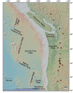
Figure 1. Bathymetry & topography of the Cascadia margin and associated tectonic elements. Significant arc volcanoes indicated by orange triangles. Map generated using GeoMapApp.
Background and Motivations
GeoPRISMS and EarthScope co-sponsored this science workshop on Cascadia, held April 4-6, 2012 at the World Trade Center in Portland, OR, as a joint effort to foster communication and collaboration among researchers with diverse interests in Cascadia. The broader goal was to inform and revise guiding documents for both communities. The following is a synopsis of the workshop, which is summarized more completely in a workshop report which can be found on-line at http://www.geoprisms.nineplanetsllc.com/past-meetings/207-cascadia-apr2012.html.
The Cascadia subduction zone, which cuts through three US states and western Canada (Figure 1), is the only region of the lower 48 states that is capable of producing a Mw 9 earthquake and has the greatest potential for volcanic eruptions in the conterminous US. A trove of new geological, geodynamic, and geophysical data has recently been collected and more will be forthcoming in the next several years, thanks in part to NSF investments in EarthScope and the onshore/offshore ARRA-funded Amphibious Array Facility (AAF) of the Cascadia Initiative (CI) [See GeoPRISMS Newsletter, Issue 27 for more information]. The Cascadia margin was also chosen as a Primary Site of the NSF GeoPRISMS program during the Subduction Cycles and Deformation (SCD) Initiative Implementation Workshop in 2011, and is thus recognized as a focal point of interest to a broad base of scientific communities. With so many other onshore and offshore research efforts in process or planning stages, the time was right to hold a science workshop to build synergies among communities, disciplines, and agencies with scientific interests in the area. Ongoing/future scientific efforts in Cascadia will benefit greatly from communication and coordination among these diverse groups.
The workshop took as its starting point the Cascadia SCD portion of the GeoPRISMS Science and Implementation Plans (http://www.geoprisms.nineplanetsllc.com/science-plan.html) and the EarthScope Science Plan. The primary goals of the workshop were to: (i) to clarify common research objectives within Cascadia; (ii) to address the range of interacting tectonic, magmatic, and surficial processes acting along the convergent margin; and (iii) to update implementation plans and timelines for GeoPRISMS and EarthScope research, considering available resources and infrastructure. A key additional goal of the workshop was to tap a broad cross-section of researchers working in Cascadia, or interested in future opportunities, and to foster interaction and discussions leading to new collaborations and understanding. This specifically included entraining early-career scientists (students, postdocs, and new faculty) interested in furthering Cascadia science.
Overview
The workshop was attended by nearly 180 participants (Figure 2), including ~60 graduate students and post-docs, for two days of talks and discussion in Portland, OR. The workshop aimed to provide a platform for review and synthesis of the current state of Cascadia science, involving a wide range of topics from tectonics to geophysics/geochemistry to sedimentation and beyond, and an open forum for discussion of the future directions of scientific research in Cascadia. A student symposium took place on the day before the workshop, introducing graduate students and post-docs to the Cascadia system through a series of talks and a regional field trip. The 2-day workshop was organized into a series of broad plenary talks to provide an overview of the Cascadia subduction system, interleaved with topical break-out sessions, short presentations on hot-topic science, poster sessions, and plenary discussions.
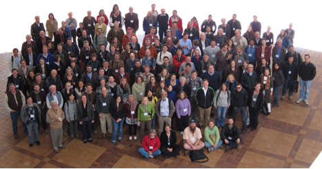
Figure 2. Participants at the GeoPRISMS-EarthScope Cascadia Workshop in Portland, April 2012.
The first day opened with plenary presentations on the tectonics, volcanism, faulting, and deep structure of the Cascadia subduction system, followed by updates on the current major projects ongoing in the Cascadia region. A set of evening discussion sessions (Special Interest Groups, or SIGs), focused on these major projects, providing opportunities for informal discussions of the details of each project, and helped define pathways for future research to link in to these efforts. The second day of the workshop opened with a plenary session on sedimentary processes in Cascadia, followed by two sets of special interest group (SIG) break-out discussions targeted at communities with interests in particular scientific questions or processes relevant to Cascadia. These discussions were followed by shorter plenary presentations on the geohazards specific to the Cascadia margin, and reports by each of the breakout groups summarizing the main discussion points in each session. The workshop wrapped up with a presentation from the student participants in the workshop, and an open plenary discussion outlining a “roadmap” to the future of Cascadia science.
For the GeoPRISMS community, one of the key objectives of the Cascadia workshop was to obtain input to refine the directions of GeoPRISMS research in Cascadia. In particular, the outcomes of the breakout and plenary discussions at the workshop will be incorporated into an updated version of the GeoPRISMS Implementation Plan (IP) for the Cascadia Primary Site (e.g., /science-plan.html). This document provides guidance to principal investigators interested in submitting proposals for funding under the NSF GeoPRISMS Program. Although proposals for research in Cascadia have been accepted under the GeoPRISMS solicitation since 2010, input from the community to clarify the research priorities for GeoPRISMS in Cascadia has been limited, with a strong emphasis on projects linked to the Cascadia Initiative.
Thus, a main goal of this workshop was to open an interdisciplinary dialog that would enable an integrated view of the Cascadia subduction zone, to solicit and incorporate feedback on science implementation in Cascadia from a broad-based community, and to provide focus and guidance for subsequent GeoPRISMS proposal solicitations.
For the EarthScope community, this workshop provided an integrative scientific dialogue building on the transformative observations from its augmented geodetic, magnetotelluric, and seismological facilities in Cascadia. Numerous science targets identified in the EarthScope Science Plan were illuminated in the presentations and discussions from the workshop. Initial research results from jointly NSF-funded EarthScope and GeoPRISMS projects were presented and momentum for additional joint proposals was evident and encouraged. In addition, IRIS and UNAVCO as the respective managers of the seismological and geodetic facilities of EarthScope are currently developing proposals for 2013-2018 operations and maintenance. The community discussions about science targets, priorities, and opportunities for coordination with other programs such as GeoPRISMS provide essential fodder for these necessarily integrative proposals.
Student Symposium
An important aspect of any scientific meeting is the engagement, preparation, and inspiration of the next generation of scientists and leaders. The student symposium, held before the workshop and attended by thirty-three students and two postdocs from thirteen universities, brought together representatives from this vital demographic, coordinated by Andrew Goodliffe (University of Alabama) with help from the GeoPRISMS Office and several workshop conveners and participants. Introductions to the GeoPRISMS and EarthScope Programs were followed by overviews of the geology and geophysics of the Cascadia region. The students and postdocs then took over the stage, giving one-slide descriptions of their research. Those presenting posters had an opportunity to highlight the work that they would be presenting later in the meeting.
In the afternoon, Ray Wells (USGS) and Ian Madin (Oregon Department of Geology and Mineral Industries) led a fieldtrip through the Portland metropolitan area. Participants got to see a spectacular Columbia River Basalt outcrop, evidence of mass wasting, a panorama of the Portland Basin and rocks form the Boring volcanic field flow. The field trip ended at the Zoo station of the Portland MAX light rail system where a spectacular core (recovered during the construction of the 3-mile-long tunnel) is displayed.
In the evening, following the icebreaker for the Cascadia workshop, symposium participants participated in a lively group dinner at Kell’s Irish Pub. Several workshop scientists joined the group and shared insights about their career path and the GeoPRISMS/EarthScope programs.
Workshop Program
- Cascadia Crustal Evolution and Deformation
- Earthquakes and Other Faulting Processes
- Large-scale and Deep Processes
- Sediment Transport, Accretion, and Subduction
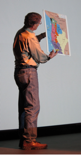
Figure 3. Ray Wells demonstrates present-day Cascadia plate motions.
Each topic was provided several keynote presentations, all of which can be found on the meeting website. These presentations led to stimulating plenary and break-out discussions.
The Cascadia Crustal Evolution and Deformation session highlighted the geological evolution of the Cascadia margin (Ray Wells, Figure 3), the pre-Quaternary magmatic history of Cascadia (Anita Grunder) and the history of recent magmatism and volcanism (Kathy Cashman).
On the topic of Earthquakes and Other Faulting Processes, a primary focus of both EarthScope and GeoPRISMS research at Cascadia, three different perspectives were offered, including new observations from the recent Tohoku earthquake and ongoing and planned work in Japan (Shuichi Kodaira), paleoseismic studies of past megathrust earthquakes along the Cascadia margin (Rob Witter), and recent seismicity and tremor activity along the Cascadia margin (Ken Creager).
The session on Large-scale and Deep Processes focused on the large-scale processes that control subduction system dynamics, with an emphasis on those processes that occur deep with the subduction system, such as the thermal-petrologic-fluid flow structure and dynamics of subduction zones (Ikuko Wada), the geodynamic framework of the Pacific Northwest, in light of new data obtained from seismic tomography and other sources (Gene Humphreys), and magma generation in Cascadia, in particular, reasons for the anomalously hydrous magmas in this hot system (Tom Sisson).
A session on Sediment Transport, Accretion, and Subduction addressed the Cascadia forearc as a setting for the transport of sediment from the Coast Ranges through the estuaries offshore to the accretionary prism and the abyssal plain, with topics ranging from the driving forces for erosion initiated through wedge dynamics (Mark Brandon), to deformation of sediment in the offshore accretionary wedge (Lisa McNeill) to the mechanisms and processes of delivery of sediment to the continental slope and abyssal plain by turbidites (David Piper).
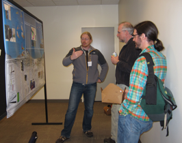
Figure 4. Attendees participated in animated conversations during poster sessions.
Workshop attendees also participated in stimulating poster sessions addressing a wide range of Cascadia and related research topics (Figure 4). Poster-viewing time was provided during both days of the meeting schedule, and posters were well attended during these times, as well as at other times during the meeting.
Volunteers served as judges for the excellent posters that many of the students and postdocs presented. Although all of the presentations were of high quality, three posters rose to the top. These were: Allison Koleszar (postdoc, Oregon State University); Jason Patton (Ph.D. candidate, Oregon State University); and Wanda Vargas (M.S. student, Cornell University). Each student received a copy of the book “In Search of Ancient Oregon: A Geological and Natural History”, by Ellen Morris Bishop.
Special Interest Group (SIGs) discussions during the workshop to discuss scientific topics, targets, and research approaches relating to specific processes or approaches, for example, Deep Subduction Zone Structure, Megathrust Structure and Processes, Outer Forearc Structure and Segmentation, Geodetic Processes, Magmatism and Volcanic Processes, Volatile Processes and Cycles, and Sedimentary Processes. Each session was asked to address the following questions: (a) What are the key exciting scientific questions that can be addressed in Cascadia? (b) What infrastructure exists in Cascadia research to address them? (c) What knowledge gaps remain to be filled; what are future research directions? And (d) What challenges exist, and how can they be overcome? The follow-up break-out reports guided the closing discussions on the final day of the workshop.
In addition, several Implementation Interest Groups broke-out to review the status of ongoing projects, and to brainstorm about future efforts specific to Cascadia. Topics included Cascadia Initiative & Amphibious Arrays, Volcano Imaging, Geohazards, Energy & Mineral Potential, and Education & Outreach. Similar questions were posed to these break-out groups, including: (a) What infrastructure exists for Cascadia; what are associated opportunities? (b) What major research products and data streams will be available? (c) What gaps remain to be filled; what are the future directions for research? (d) What challenges exist, and how can they be overcome? Additional presentations addressed the important and diverse topic of Cascadia Geohazards, including those related to earthquakes, tsunamis and volcanoes. They also addressed the major new direction of earthquake early warning.
Throughout the workshop, students participated in plenary and breakout sessions, enthusiastically contributing to discussions. During lunches and in the evening, when most workshop participants had long since left the convention center, the symposium participants were still found hard at work. The students and postdocs ultimately developed a consensus statement emphasizing their take on the key aspects of the Cascadia system and the important scientific breakthroughs yet to come.
Roadmap to the Future – Science Implementation at Cascadia
Throughout the meeting, several key issues emerged from the presentation and discussions. A selection of these is listed below, and collectively they constitute a roadmap for refining the Cascadia science implementation plan. In most cases these issues cut across traditional discipline boundaries, and our understanding of them is impacted by multiple datasets.
The nature of segmentation along the subduction zone. Diverse data sets (geophysics, seismicity, volcano age and distribution, geochemistry, geodesy and paleogeodesy, etc.) reveal that the subduction zone is segmented along strike. Key uncertainties remain. Is the segmentation the same for different data sets? What are the ultimate controls of segmentation evident in different data? What is the influence of the incoming plate on segmentation? What is the influence of the inherited crustal structure and composition of the upper plate?
Earthquakes and the turbidite record. Inferences have been drawn from turbidite records that earthquakes rupture only part of plate boundary (M>~8 events) have regularly occurred in southern Cascadia with the northern portion rupturing only in entire-boundary, M9 earthquakes. These suggestions warrant further study as they have important impacts on hazard estimates and our basic understanding of the earthquake cycle along the plate boundary.
The hot and dry slab paradox. Uncertainty remains in reconciling the geochemical and petrological estimates of volatile fluxes in Cascadia with thermal models that predict a hot and dry subduction system. At present, measurements of pre-eruptive water contents seem relatively normal (compared to other arcs) in Cascadia basalts, however thermal models predict early dehydration and devolatilization. This remains an enigma for Cascadia. The relationship between timing of dehydration, extent of dehydration and the role of volatile fluxes in magmatism remains unclear.
Distribution of volcanism. What are the ultimate controls on the distribution of volcanism in Cascadia? Specifically, what parameters influence the formation of large central volcanoes that occur along the arc versus the more dispersed monogenetic volcanism that characterizes the regions between the larger volcanoes? Can this distribution be linked to the slab, structures in the mantle wedge, or in the upper plate? How do the relatively localized back-arc volcanic complexes (Simcoe, Newberry, Medicine Lake) relate to the arc system? What are the roles of mantle fluxes, solid/fluid flow vectors, and crustal magma processing?
Role of surrounding regions. Cascadia did not develop in isolation, and important questions remain regarding the evolution of Cascadia in relation to surrounding geologic provinces? These include the Yakima fold and thrust belt, the Basin and Range, The High Lava Plains, Klamath/Sierra block, the Yellowstone hot spot trail and the Juan de Fuca ridge. How have the interactions between these geologic provinces changes through time to influence the formation and evolution of the North American continent?
Imaging the physical properties deep within the crust and upper mantle. Different models of subduction processes, including the transition from stick-slip to stable sliding along the megathrust and the migration of magma through the crust, are difficult to image geophysically. How can traditional techniques for imaging subsurface seismic velocity and electrical conductivity be improved to better image these processes? How can better images be integrated with other geophysical and geochemical observations?
Sediment transport. The transport of sediment from the subaerial forearc to offshore is a response to tectonic processes. Also, the sediment records of such transport provide insight to the past tectonic events. Specific questions relate to the role of subduction zone earthquakes in initiating landslides, in mobilizing sediment sources and in modulating estuaries as sediment storage compartment or conduits for offshore sediment delivery. Can records from lakes, especially landslide-dammed lakes, be archives of erosion history in the Coast Ranges? How effective are carbon and other biomarkers in tracing sediment through watersheds to the offshore and can these methods, along the sediment transport data, be applied to determine sediment mass balances for Coast Range watersheds located at different latitudes along the Cascadia margin?
These topics, arising from discussions at the Cascadia workshop, informed the implementation plan developed for the Cascadia margin, specifically to guide proposals submitted to the GeoPRISMS Program, but of broad interest to the research community. The full workshop report for the Cascadia Science Workshop and the final GeoPRISMS Implementation Plan can be accessed and downloaded from the meeting website: http://www.geoprisms.nineplanetsllc.com/past-meetings/207-cascadia-apr2012.html