1University of Oregon, 2 North Arizona State University, 3University of California, Davis
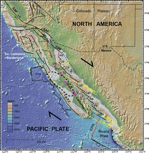
Figure 1. Map of topography, bathymetry, faults, and geophysical transects (Gonzalez-Fernandez et al., 2005; Lizarralde et al., 2007) in the Gulf of California – Salton Trough region. Systematic shallowing of water depth from south to north along the plate boundary is due to voluminous input of sediment from the Colorado River (Col. R.) in the north. Bold dashed line shows area of high-velocity anomaly at a depth of 100 km that indicates the presence of a stalled fragment of the Farallon plate in the upper mantle; purple color shows areas of post-subduction high-Mg andesites (Wang et al., in press). AB: Alarcón basin; BTF: Ballena transform fault; CaB: Carmen basin; CB: Consag basin; CPF: Cerro Prieto fault; DB: Delfin basin; EPR: East Pacific Rise FB: Farallon basin; GB: Guaymas basin; GF: Garlock fault; Gmp: Guadalupe microplate; IT: Isla Tiburón; Mmp: Magdalena microplate; PB: Pescadero basin; SAF: San Andreas fault; T.A.F.Z.: Tosco-Abreojos fault zone; TB: Tiburón basin; WB: Wagner basin.
How and why do continents break apart? Under what conditions does rifting progress to rupture of the lithosphere and formation of a new ocean basin? Can we identify the state parameters, physical properties, and forces that control this process? The Rupturing Continental Lithosphere (RCL) initiative of the NSF-MARGINS program was implemented to address these and related questions through integration of onshore-offshore geophysical, geological, and modeling studies. After marine investigations of the Red Sea rift became impractical due to geopolitical factors, the Gulf of California and Salton Trough became the sole focus site for the RCL initiative.
In this report, we highlight some of the key findings that have emerged from 10 years of RCL research along the Gulf of California – Salton Trough oblique divergent plate boundary (Fig. 1). A central goal of these studies was to better understand the spatial and temporal evolution of rifting and rupturing processes by linking data and observations with insights from numerical models and experiments. Researchers addressed questions regarding: forces and processes that govern rift initiation, localization, and evolution; key controls on deformation as it varies in time and space; physical and chemical evolution of the crust as rifting proceeds to sea-floor spreading; and the role of fluids and magmatism in continental extension. The following summary highlights results of recent studies, many of which have changed the way we think about continental rifting, rupture, and the underlying controls on these processes.
Upper-Mantle Structure
Complex upper-mantle structure beneath the Gulf of California – Salton Trough region reflects evolution of the plate boundary from a convergent-margin subduction zone and magmatic arc to the modern system of short spreading centers linked by long transform faults. Using Rayleigh-wave tomography, recent studies identify a fast anomaly in seismic velocity beneath the central Baja California peninsula and western Gulf (Wang et al., 2009, in press; Zhang et al., 2009). This anomaly is interpreted to be a fragment of the former Farallon plate that became stranded by slab detachment at a depth of ~100 km during failed subduction of the Farallon-Pacific spreading center. A discontinuous belt of post-subduction high-Mg andesites (bajaites) coincides with the landward edge of the stranded slab segment (Fig. 1), and is interpreted to record partial melting of ocean crust and upper mantle due to upwelling associated with opening the Gulf of California and/or replacement of detached lithosphere with hot asthenosphere at the end of the broken slab (Burkett and Billen, 2009; Wang et al., in press). Brothers et al. (2012) used seismic refraction data to identify another, shallower segment of stalled ocean crust at ~20 km depth beneath the southern peninsula. They concluded that slab detachment at ~12 Ma, and subsequent isostatic and thermal response, controlled the late Neogene history of uplift, erosion, subsidence and sedimentation on the Magdalena shelf off southern Baja California.
Receiver function studies show that continental crust of the Peninsular Ranges and Baja California microplate thins dramatically from about 40 km in the west to 15-20 km in the east, at the western margin of the Gulf Extensional Province (Lewis et al., 2000, 2001; Persaud et al., 2007). These results show that the eastern Peninsular Ranges lack an Airy crustal root, and that high topography in this area is instead supported by upper mantle buoyancy and a thinned mantle lithosphere. The geometry, distribution and post-Pliocene timing of rift-flank uplift suggest that removal or modification of mantle lithosphere is related to the modern phase of crustal extension driven by transform tectonics (Mueller et al., 2009), and is not inherited from an earlier period of Miocene extension. Mechanisms accommodating regional deformation of the lower crust and upper mantle are uncertain but may include lower crustal ductile flow, low-angle normal faulting, and convective instabilities in the lithosphere (Gonzalez-Fernandez et al., 2005; Persaud et al., 2007; Mueller et al., 2009).
Localization of Strain
One of the major questions that motivated RCL research was: how, where, and why does strain localize as rifting progresses to continental rupture (Umhoefer, 2011)? It has long been known that in some regions (such as the Basin and Range) the crust undergoes extension over large areas for 10’s of millions of years without breaking the continent. So why does strain rapidly become localized in some settings to rupture the lithosphere and form a new ocean basin? A decade of research in the Gulf of California – Salton Trough region generated new understanding of several key processes that control localization of strain in rift systems: (1) magmatism; (2) microplate coupling; (3) strike-slip faulting; and (4) sedimentation.

Figure 2. Seismic velocity models showing crustal-scale structure for 4 transects in the Gulf of California. The top, northernmost transect is from Gonzalez-Fernandez et al. (2005), and the lower 3 transects are from Lizarralde et al. (2007; PESCADOR experiment). Velocity contours in the lower 3 panels are color-coded and labelled in units of km/s. Yellow diamonds indicate instrument locations. COT is the interpreted continent/ocean transition. See Figure 1 for location of transects. The rift architecture seen in these transects alternates abruptly along the rift between wide-rift and narrow-rift mode. The observed variations in rift architecture likely reflect some combination of pre-rift magmatism and thickness of sediments in the basins.
Magmatism
Marine-seismic studies in the northern Gulf (Gonzalez‐Fernandez et al., 2005) and central to southern Gulf (Lizarralde et al., 2007) investigated crustal-scale structure and controls on rift architecture. Four transects reveal surprisingly abrupt variations in the geometry of rift segments and the width of extended continental crust (Figs. 1, 2). The northern Gulf transect is characterized by a broad diffuse crustal geometry, intermediate seismic velocities in the mid to lower crust, and lack of well defined ocean crust that may reflect the influence of thick sediments and lower crustal flow during extension (Gonzalez‐Fernandez et al., 2005). Rift segments in the central to southern Gulf alternate between wide- and narrow-rift geometries that Lizarralde et al. (2007) proposed are controlled by the presence or lack of pre-rift magmatism. According to this hypothesis, the upper mantle became chemically depleted in areas of early to middle Miocene, pre-rift ignimbrite eruptions. Chemically depleted mantle resulted in sparse syn-rift magmatism, thin basaltic crust, and a wide-rift architecture (Alarcon segment) that reflects the paucity of magma and a relatively strong lithosphere. Conversely, areas that were not affected by Miocene ignimbrite magmatism were inferred to have retained a fertile upper mantle that enhanced production of syn-rift magma, thus weakening the lithosphere and promoting a narrow-rift architecture (Lizarralde et al., 2007).
Behn and Ito (2008) used 2-D numerical models to explore the thermal and mechanical effects of magma intrusion on fault initiation and growth at slow and intermediate spreading ridges. Faulting is influenced by competing factors of lithospheric structure, rheology, and rate of magma accretion at the ridge axis, and that faulting typically follows a predictable pattern of initiation, growth, and termination. Fault growth in these models generates a strongly asymmetric thermal structure that can stabilize slip on large-offset normal faults, and may localize hydrothermal circulation into the footwall of evolving core complexes. Through integrated modeling and experimental studies, Takei and Holtzman (2009) found that, for a solid-liquid system in which solid grains deform by grain-boundary diffusion creep, addition of a very small amount of melt (phi < 0.01) results in significant reduction of effective bulk and shear viscosities. This means that very small melt fractions in the upper mantle will lead to substantial weakening and localization of strain. Bialas et al. (2010) used a 2-D numerical model to better understand how magma-filled dikes influence the evolution of fault stresses, heat, and lithospheric weakening. They found that only a small amount of magma is needed (<4 km of cumulative dike opening) to weaken the lithosphere such that strain may become localized and continue to ocean spreading by tectonic extension without input of additional magma.
Microplate Coupling and Strike-Slip Faults
Recent GPS studies provide new constraints on modern plate motions, plate rigidity, surface velocities, and kinematic boundary conditions in the Gulf of California – Salton Trough region. The Baja California microplate behaves as a rigid block that moves in approximately the same direction as the Pacific plate but ~10% slower than the Pacific plate (Plattner et al., 2007). Thus the microplate is incompletely coupled to the Pacific plate along the offshore Tosco-Abreojos fault zone (Fig. 1), and this “neighbor-driven” motion of the microplate drives northwest-directed rifting and seafloor spreading in the Gulf of California (Plattner et al. 2009). Mechanical coupling to the Pacific Plate is likely enhanced by the presence of shallow-dipping fragments of the former subducting Farallon plate beneath the Baja peninsula (Zhang et al., 2007; Wang et al., 2009; Brothers et al., 2012).
Existing regional seismic profiles run between and parallel to long transform faults that link short spreading centers (i.e. Gonzalez-Fernandez et al., 2005; Lizarralde et al., 2007), and therefore do not fully address questions about complex 3-D strain and regional strain partitioning in oblique rifts. A recent study by Brune et al. (2012) explored this question using a simple analytic mechanical model and advanced thermomechanical numerical techniques. They found that oblique extension is favored, and more efficient, than orthogonal rifting because it requires less force to reach the plastic yield limit of the lithosphere. This result suggests that oblique extension can exert a major control on localization of strain that evolves to lithospheric rupture, and may explain why continental extension progressed rapidly to rupture in the Gulf of California and Salton Trough (Umhoefer, 2011).
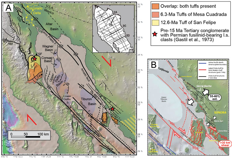
Figure 3. (A) Map of topography, bathymetry, faults and basins in the northern Gulf of California, compiled from numerous published sources. The northern Gulf contains several pull-apart basins bounded by large transform faults. Active diffuse deformation in the Delfin basin occurs on closely-spaced oblique-slip faults, and there is no evidence for existence of oceanic crust at depth. Much of the crust is sedimentary due to the high rate of input from the Colorado River. ABF, Agua Blanca fault; CDD, Canada David detachment; SPMF, San Pedro Martir fault. P, Puertecitos; SF, San Felipe. (B) Simplified tectonic model for late Miocene to modern kinematic evolution of the northern Gulf of California. Geologic relations in coastal Sonora record a period of NE-SW extension between about 10 and 6 Ma (black faults; Darin, 2010), and rapid focusing of strain into a narow zone of dextral transtensional deformation and related offshore faults at ca.7-8 Ma (red faults; Bennett et al., in press). Plate boundary motion now occurs on the Ballenas transform (blue faults).
The prediction that oblique rifting controls strain localization is supported by recent geologic mapping and structural studies in the northern Gulf of California and coastal Sonora region (Fig. 3). Geologic mapping and fault-kinematic analysis provide evidence for large magnitude (55-60%) NE-SW extension between about 10 and 6 Ma in the Sierra Bacha, immediately northeast of a major dextral shear zone (Darin, 2011). During this time, at ~7-8 Ma, strain became focused into a narrow zone of strong transtensional deformation and related transform faulting (up to ~100% local extension) in coastal Sonora and Isla Tiburon (Bennett et al., in press). These studies highlight the important role that strike-slip faults played in localizing transtensional strain into the northern Gulf of California shortly prior to lithospheric rupture. In contrast, Busch, et al., 2011 and 2013 and Umhoefer, et al., in review showed that normal faults remain active – but at low slip rates (<1 mm/yr) – along the Gulf Margin fault system at the latitude of La Paz.
Sedimentation
Recent studies call attention to the critical role that sediments play in continental rifting, lithospheric rupture, and formation of new ocean basins. Bialas and Buck (2009) developed a two dimensional mechanical model that explores the buoyancy effects of adding a load of non-locally derived sediment to an evolving rift system. In the absence of a sediment load, the buoyancy force contrast between areas of thinned and un-thinned crust hinders rift localization and promotes a wide-rift mode of extension. Conversely, if non-locally derived sediment is added to the rift zone, this reduces the contrast in buoyancy force and allows extension to persist within the rift, causing strain to become localized and hastening the time to rupture (Bialas and Buck, 2009). It is not clear, however, how the effect of buoyancy forces compares to the thermal effect of adding sediments, which may warm and weaken the lithosphere due to thermal blanketing (e.g. Lizarralde et al., 2007) or cool and strengthen a rift by adding a large volume of cold material to the crust.
Sediments and Crustal Recycling
It is now clear that voluminous input of sediment from the Colorado River exerts a first order control on rift architecture, crustal composition, and lithospheric rupture in the northern Gulf of California and Salton Trough region. We observe a pronounced change from sediment-starved, deep-marine seafloor spreading centers with thin basaltic crust and magnetic lineations in the southern Gulf, to overfilled shallow-marine and nonmarine pull-apart basins in the north that contain thick sediments above a quasi-continental lower crust (Fig. 1; Dorsey and Umhoefer, 2012; Fuis et al., 1984; Gonzalez-Fernandez et al., 2005; Lizarralde et al. 2007). Thus the degree to which basins have completed the transition from continental rifts to ocean spreading centers changes dramatically from south to north, even though there has been roughly the same amount of extension across the plate boundary since either ca. 6 Ma (Oskin and Stock 2003) or ~12 Ma (Fletcher et al., 2007). Although pre-rift continental lithosphere has ruptured completely in the north, as it has in the south, the northern rift segments lack normal basaltic spreading centers, and deep sediment-filled basins are floored by young crust composed of Colorado River-derived sediments and mantle-derived intrusions (Fuis et al., 1984).
Recent studies have tested and appear to confirm the crustal model of Fuis et al. (1984). Using Sp receiver functions, Lekic et al. (2011) found that the lithosphere-asthenosphere boundary (LAB) beneath the Salton Trough is very shallow (40 km), and that the lateral edges of shallow LAB coincide approximately with major active faults. They proposed that the entire pre-Tertiary lithosphere beneath the Salton Trough has been replaced, and that the LAB represents the base of newly formed mantle lithosphere generated by rift-related dehydration and mantle melting. New results from the Salton Seismic Imaging Project provide additional constraints on crustal and upper mantle structure beneath the Salton Trough. Seismic velocity models reveal a ~40 km-wide basin bounded by the San Jacinto fault zone on the southwest and paleo San Andreas fault on the northeast (Han et al., 2012a,b). Crystalline “basement” at depths of ~4 to 10-12 km consists of metamorphosed Plio-Pleistocene sediment on the basis of intermediate P-wave velocities (~5.0-6.2 km/s). High heat flow results in vigorous hydrothermal circulation and emplacement of Quaternary rhyolites produced by episodic remelting of hydrothermally altered basalts (Schmitt and Vazquez, 2006; Schmitt and Hulen, 2008).

Figure 4. Diagram illustrating a conceptual model for lithospheric rupture and sedimentation in the Salton Trough and northern Gulf of California (Dorsey, 2010). Deep basins are filled with synrift sediment derived from the Colorado River to form a new generation of recycled crust along the oblique-divergent plate boundary.
Crustal extension during mid to late Tertiary time led to collapse of a pre-existing orogenic plateau, reversal of regional drainages, and diversion of the Colorado River into subsiding basins along the fault-bounded tectonic lowland (Dorsey, 2010, and references therein). In this setting, continental crust is rapidly recycled by a linked chain of processes: erosion and fluvial transport of sediment off the Colorado Plateau, followed by deposition, burial, and metamorphism in deep rift basins (Fig. 4). Dorsey and Lazear (in press) found that the volume of sediment in the basins is, within error, equal to the volume of crust (ca. 310,000 km3) eroded from the Colorado Plateau over the past ~6 m.y., but only if the calculated sediment volume includes metasedimentary crust between 4-5 and 10-12 km deep in the basins. These studies challenge geologists to think about what the middle to lower crust will look like in a setting like this if the Salton Trough were uplifted and exhumed.
Recent insights from the northern Gulf of California and Salton Trough permit recognition of a new type of rifted continental margin (in addition to popular volcanic and non-volcanic end members): one where the continent-ocean transition consists of thick, largely non-volcanic crust constructed from syn-rift to post-rift sediments (Sawyer et al., 2007). This may help explain the origin of “transitional” crust at some ancient rifted margins. Recycled sedimentary crust of this type may be recognized by an overall geometry similar to that of volcanic rifted margins but with intermediate seismic velocities that are not consistent with a simple basaltic composition (e.g. Nova Scotia margin; Funck et al., 2004; Wu et al., 2006).
Conclusions
The past decade of research in the Gulf of California – Salton Trough focus site generated new insights into the processes that control continental rifting and transition to lithospheric rupture. Several key factors – upper mantle structure, magmatism, rift obliquity, and sedimentation – were found to be especially important. An unexpected result was the discovery of abrupt contrasts in rift architecture and evolution that reflect extreme variability in governing processes and conditions along the rift axis. For example, magmatism played a major role in the south, whereas sedimentation has strongly perturbed the system in the north due to voluminous input from the Colorado River. We see a change from large-scale simple shear and lower crustal flow associated with low-angle detachment faults in the north, to early localization of strain in the central Gulf (Guaymas basin) and southern Gulf (Cabo San Lucas), to protracted, pure-shear style extension and delayed continental rupture in the south. The role of upper mantle processes is one aspect that we expect will be more fully understood by tracking the complete evolution from active rifting through the thermal-subsidence phase at ancient rifted margins. ■
Reference informationGeoPRISMS Newsletter, Issue No. 30, Spring 2013. Retrieved from http://geoprisms.nineplanetsllc.com