1University of California, Santa Cruz, 2University of South Florida, 3Cal Poly Pomona, 4Georgia Tech, 5Universidad Nacional, Costa Rica
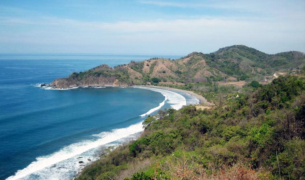
Nicoya Peninsula. Photo credit S. Schwartz
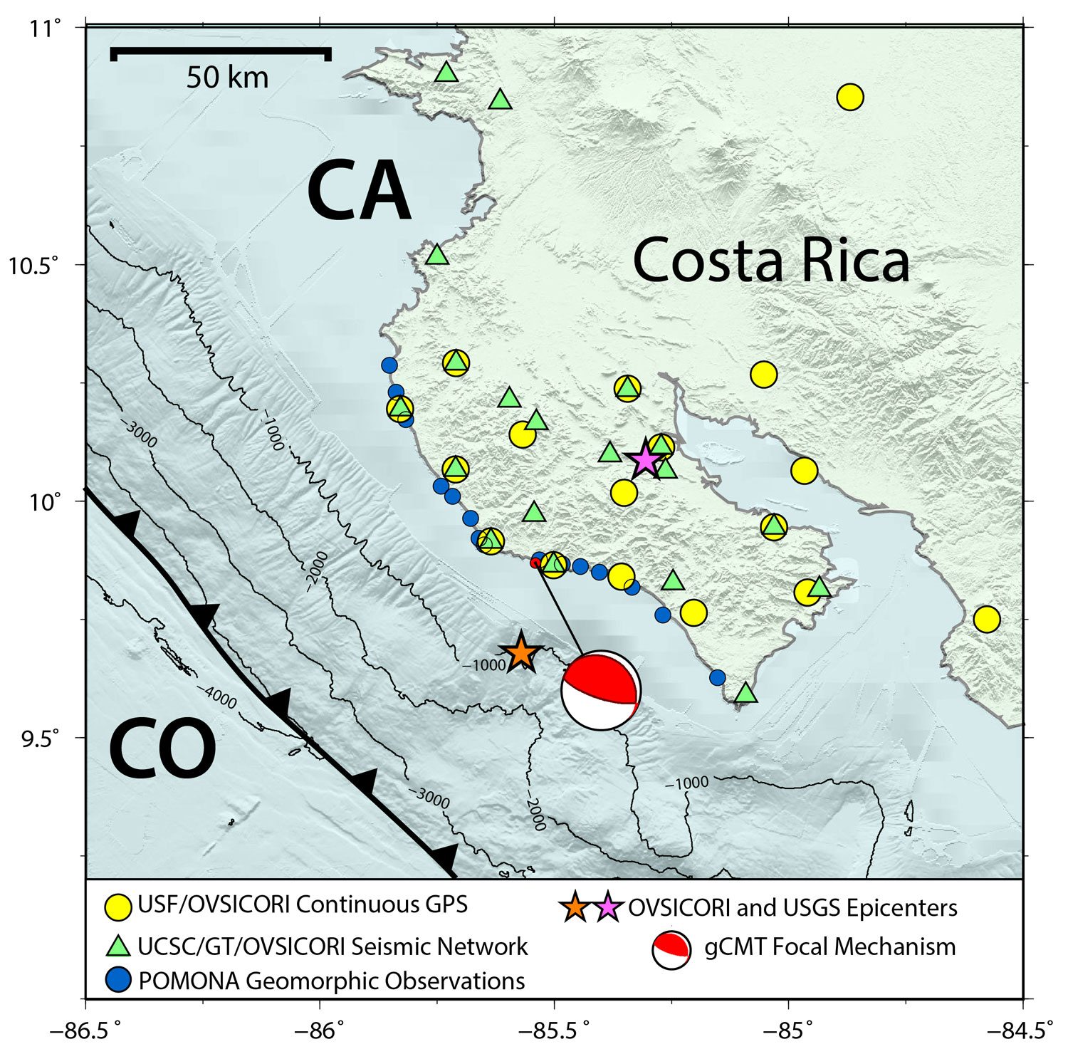
Figure 1. Distribution of GPS and seismic stations on the Nicoya Peninsula. The epicenter of the 5 September 2012 (Mw 7.6) earthquake as determined by the USGS (orange star) and OVSICORI-UNA (red star) is indicated along with the centroid moment tensor location and focal mechanism. CO: Cocos Plate, CA: Caribbean Plate.
More than a decade of MARGINS SEIZE research on Costa Rica’s Nicoya Peninsula came to fruition on 5 September 2012 when a Mw7.6 megathrust earthquake ruptured the locked Nicoya seismogenic zone, fortunately causing no fatalities.
The Nicoya Peninsula’s favorable observation geometry close to the trench, its frequency and apparent regularity of large earthquakes, and its position very late in the earthquake cycle led to the geoscience community’s 1997 selection of Central America as a focus site for the NSF MARGINS Seismogenic Zone Experiment (SEIZE). For the following 15 years the Nicoya Peninsula has been the location of intense field studies of seismicity, velocity structure, geodesy, seafloor bathymetry, coastal geomorphology, and fluxes of heat and fluid to address fundamental questions about slip behavior during major subduction zone earthquakes. The September 2012 earthquake is a fitting capstone occurrence for the SEIZE initiative. It provided an important opportunity to advance our understanding of a wide spectrum of seismogenic zone behaviors over time scales from seconds (earthquakes) to months (slow slip events) to decades and longer that are now central to the GeoPRISMS Subduction Cycles and Deformation (SCD) initiative.
The 2012 Nicoya earthquake occurred directly beneath a long operating network of seismic and GPS stations (Fig. 1). Dense seismic and GPS observations on the Nicoya Peninsula started in 2000 with the MARGINS funded CRSEIZE project and continued with installation of NicPBO, a continuously operating network of seismic and GPS instruments that was also partially supported by the MARGINS program. Presently UC Santa Cruz (UCSC), University of South Florida (USF), and Georgia Tech (GT) together with our international collaborators at OVSICORI-UNA continue to operate this network (Fig. 1). The existence of this network years before the earthquake provides a unique opportunity to study the entire earthquake cycle including any preparation processes, coseismic, and postseismic slip behavior in unprecedented detail. Work prior to this event revealed that the Nicoya seismogenic zone displays diverse slip behavior including regions accumulating strain (Lundgren et al., 1999; Iinuma et al., 2004; Norabuena et al, 2004; Feng et al., 2012) and others experiencing normal earthquakes (Newman et al., 2002), slow slip (Outerbridge et al., 2010; Jiang et al., 2012), tremor, and low and very low frequency earthquakes (Walter et al., 2011, 2013). Along strike variations in seismic coupling (Ghosh et al., 2008; Schwartz and DeShon, 2007; Stankova-Pursley et al., 2011) and physical characteristics of the subducting and overlying plates (Audet and Schwartz, 2013) were also documented.
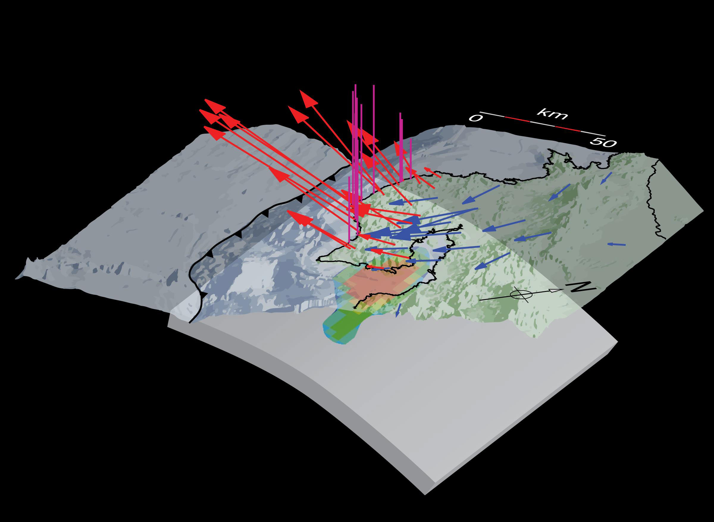
Figure 2. Perspective view of the Nicoya Subduction zone environment showing the coseismic rupture patch (color contours), and surface deformation as observed by GPS (arrows) and geomorphic changes along the coastline (orange bars). GPS data that show regional subsidence (blue) are differentiated from those points that show uplift (red). The maximum coseismic displacement is 85 cm.
Data from geodetic networks monitoring surface deformation above subduction can be used to estimate whether or not portions of the plate interface are presently locked and accumulating strain. This information is important for assessing hazard for future large earthquakes. Determining the precise regions that are locked and most likely to rupture in the next large megathrust event is, however, very difficult in most environments due to the location of the plate interface that is normally below the seafloor and relatively far from the onland observing networks. Whether or not regions of maximum interseismic strain accumulation end up rupturing in peak slip during major earthquakes is therefore not well established in most places. In contrast, the location of most of the Nicoya Peninsula’s seismogenic zone is directly underneath land, which allows detailed imaging of the locked interface (Feng et al, 2012). The occurrence of the 5 September 2012 megathrust earthquake was captured by the network and provided an unprecedented picture of the event’s coseismic deformation (Fig. 2). These and available seismic data allowed for the unique determination of the spatial extent of the coseismic slip distribution (Yue et al., 2014; Protti et al., 2014) for direct comparison between the regions of strain accumulation and coseismic slip (Fig. 3). On shore, where the patterns are extremely well-determined, the match between the two is remarkably good.
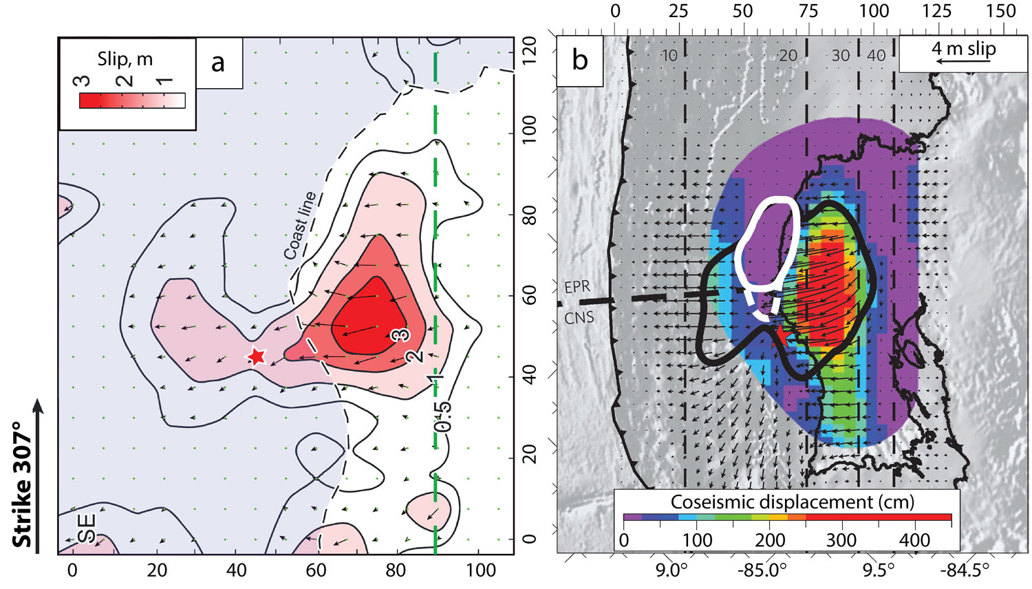
Figure 3. Slip distribution during the 2012 Nicoya earthquake determined from a) inversion of high-rate GPS, strong ground motions and teleseismic P waves (Yue et al., 2014) and b) from inversion of static horizontal GPS offsets (Protti et al., 2014). There is excellent agreement in the regions experiencing the largest slip (> 2 m).
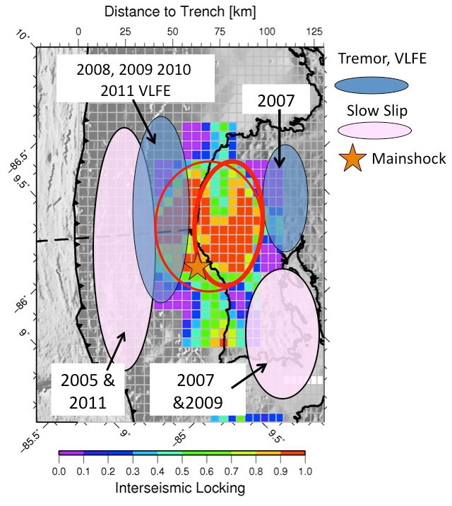
Figure 4. Spatial comparison of coseismic slip in the 2012 Nicoya earthquake (red circle), region of interseismic strain accumulation (colored contours), and areas experiencing slow slip tremor (pink and blue ovals) demonstrating segregation of portions of the plate interface experiencing different mechanical behaviors.
In the last decade, six slow slip and tremor events have been identified and characterized in this section of the Middle America Trench (Walter et al., 2011; Jiang et al., 2012). Figure 4 shows the location of slow slip and tremor superimposed on the strain accumulation pattern and region of maximum coseismic slip in the 2012 earthquake. The onshore locked patch that ruptured in the 2012 earthquake is surrounded by slow slip and tremor. This is consistent with observations at other subduction zones where aseismic slip, afterslip and seismic slip occurring during a large earthquake are located in complementary regions. The Nicoya Peninsula region provides the best support for a model of the plate interface that consists of distinct mechanical behaviors, regions accumulating strain in the interseismic period and hosting coseismic slip versus areas both up and downdip that release strain in slow slip. ■
Reference information
GeoPRISMS Newsletter, Issue No. 32, Spring 2014. Retrieved from http://geoprisms.nineplanetsllc.com