Workshop Report | NSF-GeoPRISMS Rift Initiation and Evolution Theoretical and Experimental Institute


Tobias Fischer1, Donna Shillington2
1University of New Mexico, 2LDEO, Columbia University

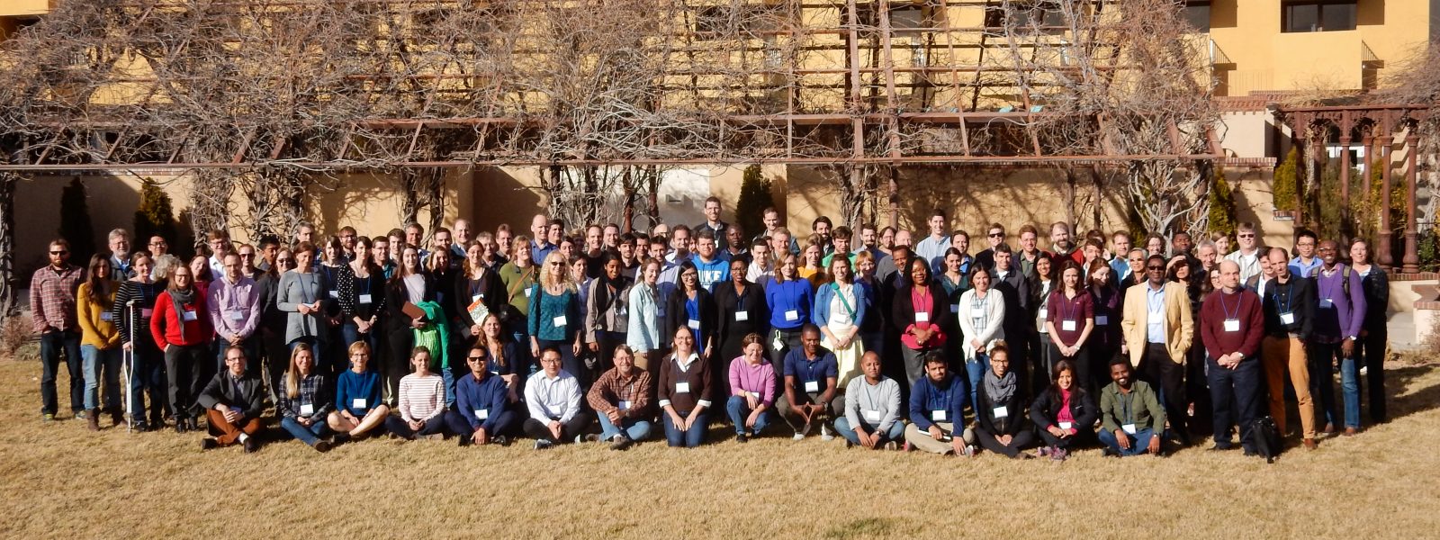
The GeoPRISMS Theoretical and Experimental Institute (TEI) for the Rift Initiation and Evolution (RIE) initiative was held February 8-10, 2017 in Albuquerque, NM. This meeting brought together 132 scientists with diverse expertise working on rifts and rifted margins around the world to discuss recent scientific advances, emerging questions, and to identify potential high-priority science for future GeoPRISMS RIE efforts. The meeting included a series of oral and poster presentations, pop ups and discussions. The workshop conveners have prepared a report that summarizes science results and future directions discussed at the workshop.

The GeoPRISMS Rift Initiation and Evolution (RIE) Theoretical and Experiment Institute (TEI) was held in Albuquerque, NM from February 7-10. The objectives of the meeting were to summarize progress and recent scientific advances related to the RIE initiative, identify high-priority science for future GeoPRISMS RIE efforts and promote community building and formation of new collaborations.

To meet those objectives, a diverse group of scientists was enlisted to serve on the convening team, give invited and contributed talks and to contribute to the meeting as attendees. The expertise of conveners, speakers and attendees spanned a broad range of interests connected with the RIE initiative, from deep geodynamical processes underlying rifting to surface processes controlling syn- and post-rift evolution. Scientists undertaking studies in the RIE primary sites (the East Africa Rift and the Eastern North American Margin) and working at other rifts and rifted margins were encouraged to contribute to all aspects of the workshop to ensure diverse perspectives. The meeting was attended by 133 participants, 59 of which were students and postdoctoral researchers. Besides attracting a large group of early career scientists, attendees included mid-career investigators who were relatively new to RIE science. Scientists from abroad were invited to attend to provide insights regarding the RIE primary sites and on rifts in general.

The meeting structure was designed to cover the broad spectrum of science included in the GeoPRISMS RIE science plan, to encourage interdisciplinarity and to bring in diverse perspectives. The main meeting had seven main oral sessions:

  1. Rift evolution from initiation to post rift architecture
  2. Geodynamics of rift and post-rift processes
  3. Magmatism and volatile exchanges
  4. Faulting and strain
  5. Surface processes & feedbacks between deep/surface processes
  6. Hazards associated with rifting environments

There was substantial time allocated for discussion and interaction; the meeting included several poster sessions at various times of day, two breakout sessions, one small-group discussion and plenary discussion after each oral session and throughout the meeting. As described in more detail below, the speakers successfully synthesized the state of knowledge on various aspects of rift evolution and of highlighting important outstanding questions. The breakouts and discussion were dynamic, generating excellent ideas and insights. The main meeting was preceded by a half-day student and postdoc symposium organized and led by three postdocs.

Overview of science presented at the meeting

Student-Postdoc Symposium

The student-postdoc symposium was held the afternoon before the main meeting and was led by Yelebe Birhanu (Bristol), James Muirhead (Syracuse), and Jean-Arthur Olive (LDEO). The organizers began the symposium with a presentation that provided an overview of the outstanding science questions related to RIE. These questions focused on the topics of rift initiation, the 4-D rift architecture, long- and short-term rift deformation mechanisms, rift volcanism, magmatism and volatile fluxes as well as surface processes at rifts and rifted margins. These topics were the focus of small group discussions later in the afternoon, and the discussion leaders summarized these discussions during the first day of the main meeting to all attendees. The symposium also included pop-ups by all participants on their RIE related research. Over sixty people attended the student-postdoc symposium, including nearly all students and postdocs at the meeting and a few representatives from the GeoPRISMS Office and GSOC, NSF and the convening team of the main meeting. The scientific discussions were followed by a career development panel discussion where students and postdocs had the opportunity to engage directly with scientists at a variety of stages in their careers.

Main meeting

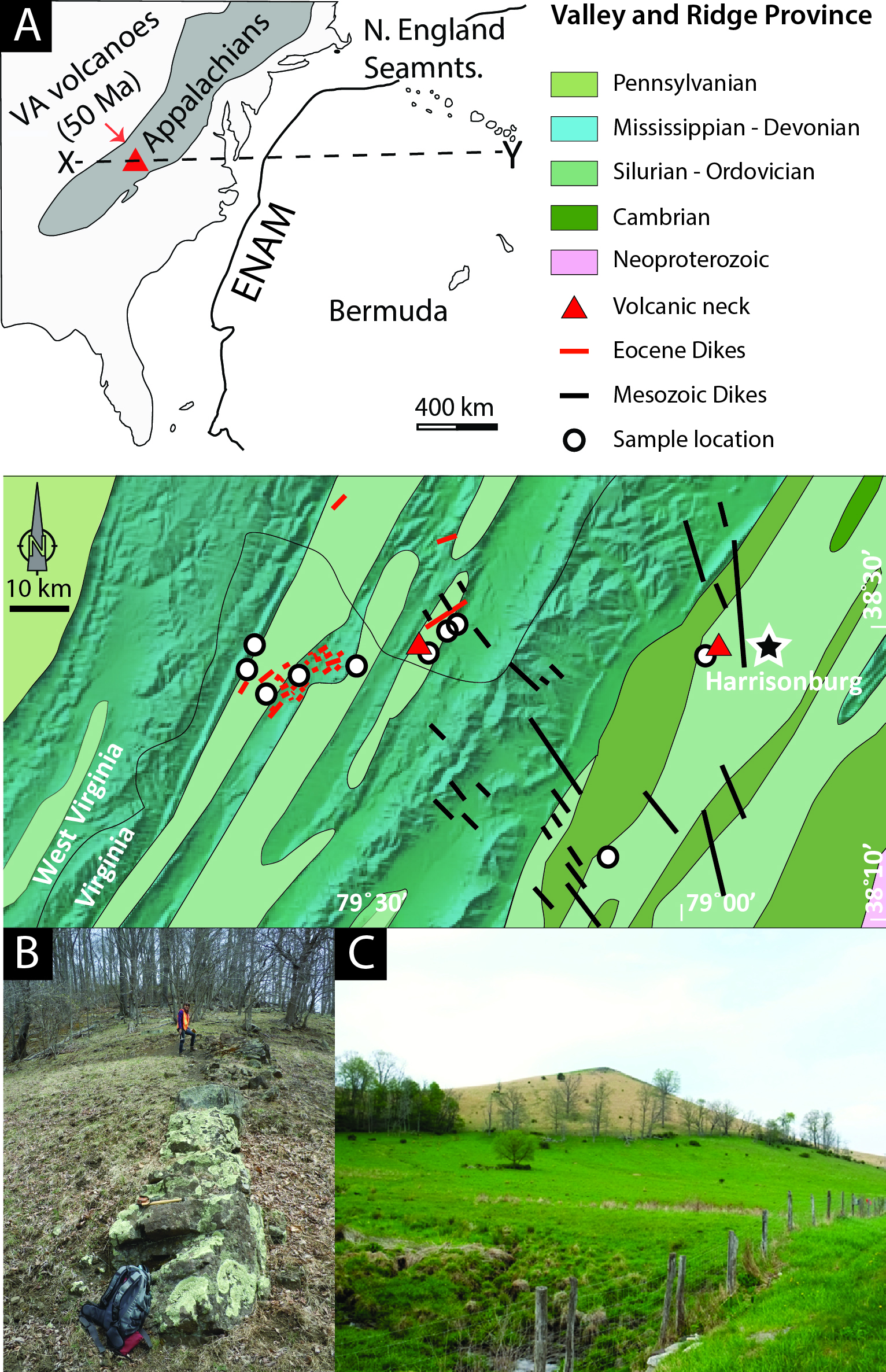
The main part of the meeting began with a session on rift evolution from initiation to post-rift architecture. Roger Buck (LDEO) emphasized the role of magma throughout the life of rifts, from diking during rift initiation to the association of rifted margins with large magmatic outpourings and seaward dipping reflectors. Harm Van Avendonk (UTIG) reviewed insights on rifting processes from studies of both magma-poor and magmatic rifted margins, where recent studies show interesting variations in the distribution and timing of magmatism in relation with rifting, including provocative clues from ENAM on distribution of magmatism and highly thinned continental crust. Danny Brothers (USGS) focused on postrift evolution of rifted margins, including how sediment delivery and pre-failure configuration control evolution and evidence for active fluid venting, slope failure, and sediment compaction.

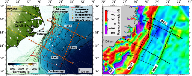
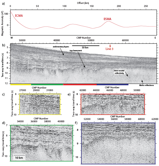
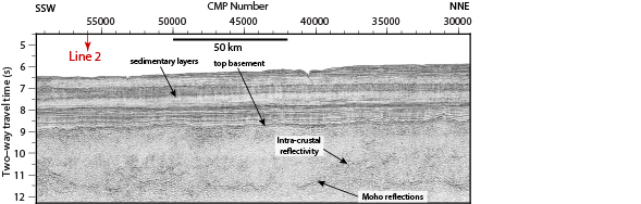
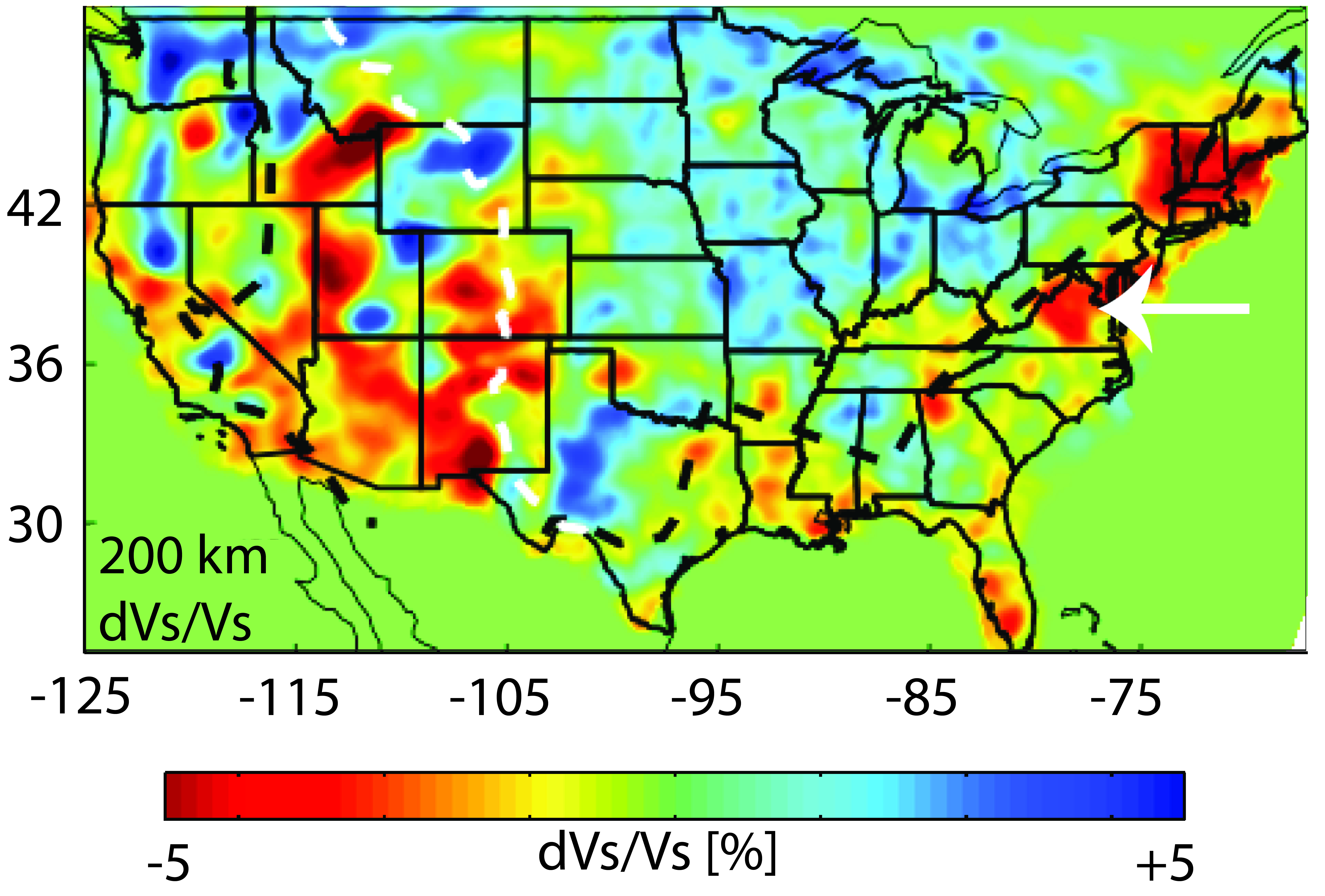
Session 2 focused on geodynamics. Jolante Van Wijk (NM Tech) provided an overview of numerical modeling approaches and the importance of testing and comparing models to both observations and other numerical solutions. Zach Eilon (Brown) synthesized geophysical observations from the Woodlark Rift in Papua New Guinea and showed evidence of limited melt, lithospheric removal and opening direction parallel anisotropy. Andrew Smythe (Penn State) showed how high-temperature thermochronology and diffusion speedometers can be used to assess mantle upwelling rates and how strain is vertically distributed during rifting. Robert Harris (Oregon State) showed high-resolution heat flow results from the Gulf of California and emphasized the role of fluid flow as well as conductive heat transfer. Colton Lynner (Arizona) showed new shear-wave splitting results from the ENAM community seismic experiment and suggests that 3-D edge driven flow at the edge of the margin can explain their observations.

Session 3 followed with talks on magmatism, volcanism and volatile exchanges. Cornelia Class (LDEO) gave an overview of the geochemical and petrological tools to identify magma and volatile sources in rift settings, highlighting the importance of using multiple geochemical systems to identify mantle components. Sara Mana (Salem State) showed chronological and geochemical data from the North Tanzania Convergence zone and highlighted the evidence for pulsed magmatism and a metasomatized mantle source. Juliane Hübert (Edinburgh) provided new insights on magma storage and pathways using magnetotelluric data in the Main Ethiopian Rift. Madison Meyers (U. of Oregon) emphasized the occurrence of large silicic volcanic centers in rift settings and showed how detailed work on volatiles recorded by melt inclusions allow for the quantification of magma ascent rates. Philip Kyle (NM Tech) ended the session with an overview of the magmatic history of the West Antarctic Rift.

Day 2 started off with the session on faulting and strain, where Cindy Ebinger (Tulane) provided a ‘recipe for rifting’ for cratonic and orogenic rifts where the difference in both crustal and mantle rheology are of critical importance for rift architecture and extension, including the possibly important but poorly known hydration state and distribution of volatiles at depth. Paul Umhoefer (Northern Arizona U.) showed how variations in inherited structures, strain partitioning, angle of obliquity and sediment input control extension in the Gulf of California – Salton trough plate boundary.

James Muirhead (Syracuse) showed the results from an interdisciplinary study in the East African Rift that better constrain the role and sources of fluids and mantle melting in the early stages of rifting and their connection to faulting. Hannah Mark (WHOI) provided new insights from modeling of observed seismic coupling coefficients that show how the thermal regime scales with seismic coupling in MOR and continental rifts. Elifuraha Saria (Ardhi) ended the session by providing an overview of geodetic constraints on crustal deformation in Africa emphasizing the fact that large parts of the continent are not adequately monitored geodetically.
Session 5 focused on surface processes and feedbacks in rifts, where Kyle Straub (Tulane) showed how geomorphology signals are stored in the stratigraphic and landscape record. His talk was followed by Jean-Arthur Olive (LDEO) who discussed the role of surface processes in the stabilization of half-graben structures. Erin DiMaggio (Penn State) talked about the connection between rift development as preserved in the stratigraphic record and the development of the Ledi-Geraru paleontological site. Liang Han (Virginia Tech) showed how rapid sedimentation in the Salton Trough resulted in the formation of new crust, delayed continental breakup and seafloor spreading, and how metamorphism of sediment can further delay final crustal breakup. Rob Gawthorpe (Colorado School of Mines) ended the session with insights on the evolution of the Corinth Rift, Greece from the onshore-offshore observations.

The final science session highlighted hazards in rifts and rifted margins. Karen Fontijn (Oxford) focused mainly on volcanic hazards in the East African Rift, emphasizing the low viscosity of rift magmas, the high potential for phreatic eruptions, and the abundance of large caldera systems as well as the role of hazardous CO2 degassing. Atalay Ayele (Addis Ababa U.) highlighted the challenges in disaster risk management in Africa that are due to limited capacity in equipment and human resources and the general level of understanding of potential risk. He also pointed to recent successes such as capacity building efforts, advances in real-time data flows, and national workshops. Maurice Lamontagne (GSC) showed how earthquakes and tsunamis related to rifting are the main hazards in Eastern Canada and how detailed mapping of ancient fault structures provides key insights on earthquake mechanisms and distributions in the region. Sang Mook Lee (SNU) highlighted the geohazards of the East Sea and the Sea of Japan and their potential to affect nuclear power plant safety.

Collaborative opportunities were discussed with presentations on the RiftVolc initiative, connections between rifting and hydrology, EarthScope and Africa Array updates.

Science themes with opportunities for near-term future studies

The TEI was designed to provide ample opportunities for participants to ask questions and discuss scientific issues related to the presentations. This was achieved through a panel discussion following each session including all speakers. Additional focused discussions occurred during two breakout sessions and small group discussions, which focused on the identification of high priority science questions and work needed to tackle these questions.

The following major science themes emerged from discussions at the TEI. For each of these themes, discussions focused on exciting recent findings and opportunities for near-term research progress through the GeoPRISMS RIE TEI initiative.

1. Tracking fluids (volatiles and magmas) through the lithosphere and with time

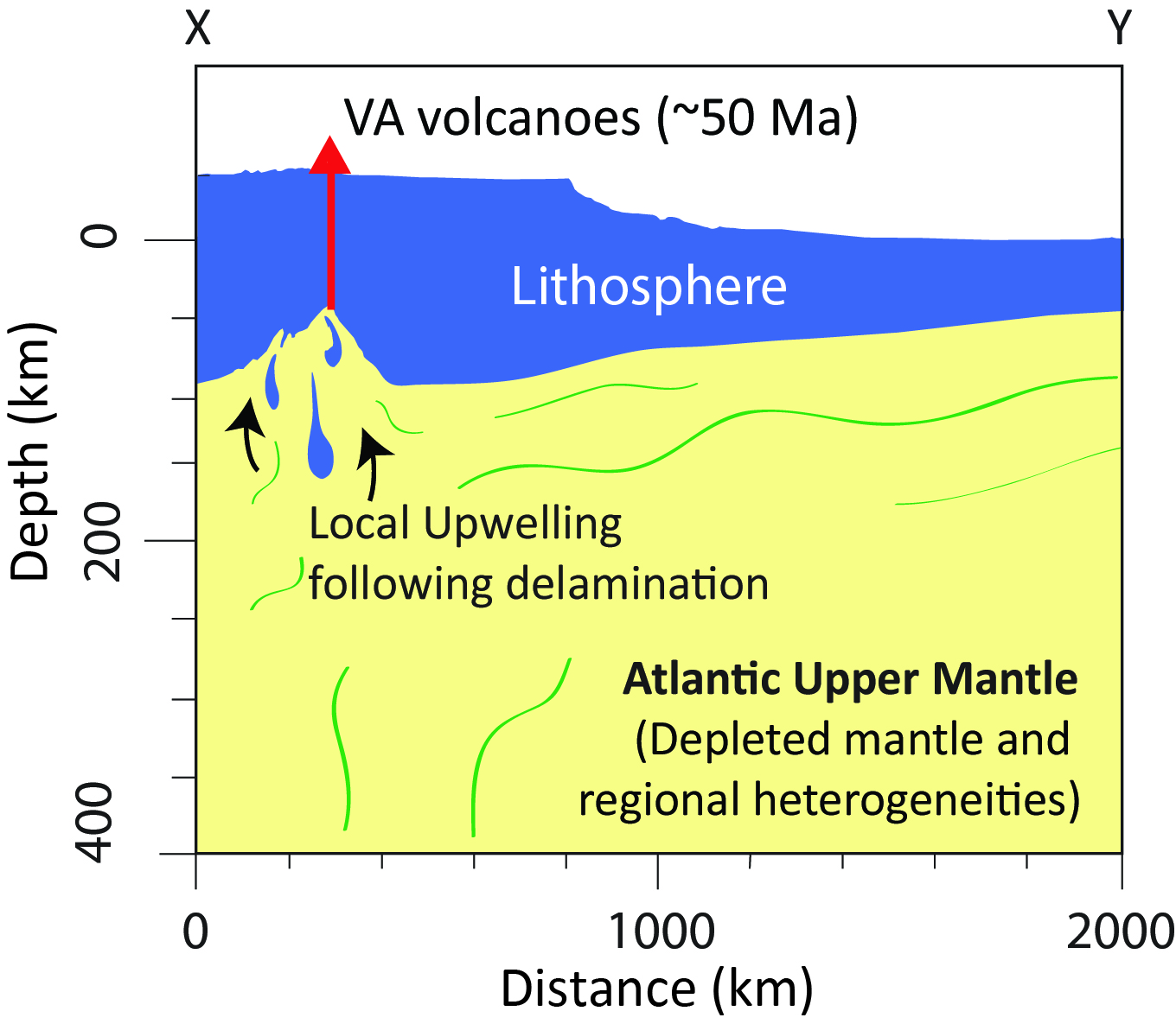
The importance of fluids for a spectrum of interconnected processes throughout the life of rifts and rifted margins was a topic of significant interest at the meeting. Meeting presentations covered recent results that have revealed strong, nonlinear interactions between volatiles and faults (e.g., talk by Muirhead), the important influence of prerift and synrift metasomatic events on magmatism (e.g., talk by Sana), and the capacity of fluids to advect heat and strongly modulate the thermal structure of rifts (e.g., talk by Harris). Geochemical tracers can be used to constrain the modification of the lithosphere by magmatic events (e.g., talk by Class). New studies of rifted margins also reveal unexpected mantle structure and magmatism, hinting at active processes long after rifting (e.g., talk by Lynner).
These new science results point to several exciting near-term future science directions:

  • Understanding the connections between deep volatiles and shallow observations, including constraining magma and volatiles residence times and pathways
  • Developing a quantitative understanding of the impact of volatiles/magmatism on strain localization and rheology (connects to theme 2)
  • Connecting general rheological models to morphological and process-based differences between magma-poor and magma-rich regions
  • Investigating the origin and significance of post-rift magmatism on rifted margins

2. Controls on deformation and localization at different temporal scales

Elucidating controls on deformation and localization are central to understanding rift processes, and were another major focus of meeting presentations and discussions. Magma is clearly a great localizer of strain (e.g., talks by Buck, Ebinger), but magma is not present everywhere, at least not in abundance. In magma-poor locations, fluids, pre-existing structures and/or chemical heterogeneity may be important factors (e.g., talks by Van Avendonk, Eilon). Volatiles appear to influence crustal rheology and fault behavior (e.g., talks by Muirhead, Ebinger), but are still poorly understood. The role of pre-existing lithospheric structure in strain localization appears to vary among rift systems and at different scale lengths (e.g., talks by Lynner, Eilon).

New numerical models and observations suggest that surface processes may also control strain localization (e.g., talks by Olive, Han; connects to theme 3). The slip behavior of rift faults (creeping, locked, etc.) is poorly known (e.g., talk by Mark), and there are few constraints on how it might change over time or with rift evolution (e.g., talk by Van Avendonk).

These new science results point to several exciting near-term future science directions:

  • Integration of rifting processes across a range of time scales from the earthquake cycle to geologic time
  • Characterization of slip behavior of faults over time and space
  • Understanding variations in temporal/spatial patterns of deformation between magmatic and magma-poor systems
  • Comparing transient behavior in rifts (creep, slow slip) to subduction and transform zones
  • Observing how volatiles are distributed through lithosphere (connects to theme 1) with an emphasis on how they impact rheology, faulting, and transient deformation
  • Constraining mantle rheology on a variety of time scales and as a function of volatile abundance, metasomatism and melt extraction processes (connects to theme 1).

3. Surface mass sedimentary fluxes and feedbacks with rifting

Recent studies have demonstrated strong connections between surface processes and all stages of rift evolution. These include the formation of new crust through rapid sedimentation (e.g., talk by Han), the impact of erosion on fault evolution (e.g., talk by Olive), the structural control of sediment pathways during and long after rifting (e.g., talk by Gawthorpe), and the structural control of slope failure (e.g., talks by Brothers and Lamontagne). The vertical displacements and crustal architecture associated with extensional tectonics strongly influence the spatial and temporal distribution of depositional domains (e.g., talks by Straub, Brothers).
These results point towards several important near-term future science directions:

  • Developing more comprehensive sedimentary histories of rifts to improve understanding of rift-related mass transport
  • Improving conceptual and numerical models of sediment influence on extensional processes, including thermal and mechanical feedbacks (connects to theme 2)
  • Utilizing the extant and paleolake systems for integrated investigations of landscape evolution.

Efforts needed to make progress on themes within GeoPRISMS

To address outstanding questions related to the themes above, the following future efforts were highlighted as particularly important.

Synthesis

Comparing among and within rifts is important to address many of the overarching RIE science questions and the specific questions within the themes above. A growing volume of data is now available in both primary sites and in other rift systems on everything from surface processes to magmatism and deep geodynamics. These observations include existing geophysical datasets on both EAR and ENAM from GeoPRISMS and other efforts, growing geochemical data and drilling data in various rifts. Particular themes discussed for syntheses were:

  • Geochemical variations along/across ENAM/EAR
  • Sediment mass fluxes from existing (limited) drilling data
  • Geochronological data on magmatic/volcanic events and surface processes
  • Crustal/lithospheric structure of rifts from existing geophysical imaging, with focus on comparisons between and within systems with variable magmatism
  • Geochemical data from geothermal exploration projects (drilling) in volcanic and non-volcanic settings.

New data collection and experimental/numerical work

From discussion at the meeting, it is clear that new data and experiments are required to tackle many important science themes, and several key gaps emerged from discussions at the meeting. Below are examples:

  • Studies of volatile systems to understand their distribution/abundance/residence time at various levels in the lithosphere. This would involve integrated geophysical imaging including but not limited to MT, seismic, and detailed geochemical studies such as melt inclusions, sampling volatiles at the surface, high density flux measurements, and other approaches.
  • Experimental and numerical modeling directed at the impact of volatiles and lower crust/mantle lithosphere hydration state/compositions on deformation throughout the lithosphere,
  • Observations to constrain the time scales of processes are needed. These include but are not limited to more geodetic observations to understand average rates and observe transient events as well as investigations of paleoseismology, deformed volcanic ash markers, and tectonic geomorphology to understand longer term accommodation of strain by events. On a longer time scale, better and improved geologic timing information is needed.
  • New constraints on sedimentary fluxes in rifts including but not limited to cosmogenic dating techniques, river incision rates, and obtaining data from new drill cores.
  • Advance the understanding of landscape evolution through better access to high resolution topographic data. ■

 icon-chevron-right For more information and browse the collection of archived presentations, please visit the TEI webpage

Report on the NSF-GeoPRISMS Rift Initiation and Evolution Theoretical and Experimental Institute . T. Fischer, D. Shillington

GeoPRISMS Newsletter, Issue No. 38, Spring 2017. Retrieved from http://geoprisms.nineplanetsllc.com

Late Stage Rifting and Early Seafloor Spreading History of the Eastern North American Margin


Anne Bécel
Lamont-Doherty Earth Observatory, Columbia University

During September-October 2014, the NSF-GeoPRISMS-funded Eastern North American Margin (ENAM) Community Seismic Experiment (CSE) collected deep penetration multichannel seismic (MCS) reflection profiles covering a 500 km wide section of the Mid-Atlantic passive margin offshore North Carolina, which formed after the Mesozoic breakup of supercontinent Pangea The ENAM-CSE data extend farther offshore than previous seismic surveys conducted in this area and encompass the full transition from continental breakup to mature seafloor spreading while specifically providing unique constraints on the events surrounding the final stage of continental rifting and the initial stage of seafloor spreading, which remain poorly understood. The results shown here demonstrate the ability of MCS data to image four distinct domains that highlight different basement characteristics and provide new insights on the degree of extensional strain localization experienced during continental breakup and how the earliest oceanic crust was formed after rifting.

Introduction

The Eastern North American Margin (ENAM) is a passive continental margin that was formed by the rifting of the Pangaea supercontinent and the opening of the Atlantic Ocean during the Late Triassic and Early Jurassic.

Figure 1. a) Elevation Map (Andrews et al., 2016) contoured every 500 m showing the location of the ENAM Community Seismic Experiment. Line 1 and ENAM Line 2 were chosen to characterize the deep structure of the Carolina Trough south of Cape Hatteras, and the Baltimore Canyon Trough north of Cape Hatteras, respectively whereas the Line 3 was chosen to characterize the structure of the crust and uppermost mantle to better understand the origin of the Blake Spur Magnetic anomaly. b) Magnetic anomaly map (Maus et al., 2009) of the North American Margin. ECMA: East Coast Magnetic Anomaly; BSMA: Blake Spur Magnetic Anomaly; IMQZ: Inner Magnetic Quiet Zone.

From offshore Nova Scotia to Florida, the ENAM has been classified as a volcanic-type margin (Marzoli et al. 1999). Multichannel seismic profiles have imaged seaward dipping reflectors (SDRs) that have been attributed to the subaerial eruption and subsequent subsidence of volcanic flows emplaced during the final phase of rifting (Austin et al., 1990). Seismic refraction profiles beneath the volcanic wedges have revealed a thick sequence of high seismic velocity lower crust rocks interpreted as igneous/magmatic underplating (Holbrook et al., 1994). The East Coast magnetic anomaly (ECMA) is a high-amplitude positive magnetic anomaly running along the length of the margin (Fig. 1) (Keller et al., 1954). The source of the ECMA has been primarily attributed to seaward dipping reflectors in the upper crust (Austin et al., 1990) and is interpreted as the limit between the continental crust and the normal oceanic crust. However, the exact nature and the width of the zone between the continental crust and normal oceanic crust remain uncertain. This zone is thought to either represent a new anomalously thick magmatic crust with higher velocity than lower oceanic crust with no continental crust present (Talwani et al., 1995) or a zone with volcanics on top of magmatic material intruded into extended continental crust or underplated beneath. The nature and the width of this zone are of fundamental importance to understanding the late stage rifting processes and over what time period the continental breakup occurred at this volcanic margin. Margins that experience a voluminous magmatism during rifting tend to have a more rapid continental breakup with a smaller zone of crustal extension (i.e. strain localization) and tend to develop more symmetric conjugate margins.

The Blake Spur magnetic anomaly (BSMA) is a positive, linear magnetic anomaly located 150-250 km to the east of the ECMA (Fig. 1). The BSMA is of lower amplitude than the ECMA but also consists of segments with several magnetic peaks separated by troughs. The age of BSMA is unknown but extrapolated ages range between 168-173 Ma. The nature and origin of this magnetic anomaly is still debated and different models have been proposed. BSMA is either thought to mark a ridge jump (Vogt, 1973), magmatic pulse associated to a plate re-organization (Klitgord and Schouten, 1986; Kneller et al., 2012) or a change in spreading rate/direction and asymmetry of incipient seafloor spreading during the early opening of the Central Atlantic (Labails et al., 2010). In the ridge jump scenario, the BSMA is thought to represent a sliver of West African rifted continental crust that experienced continental breakup magmatism and that was left on the Eastern North American margin after the early spreading center jumped east of the BSMA. This model implies that a now extinct mid-ocean ridge lies between ECMA and BSMA.

The Inner Magnetic (Jurassic) Quiet zone (IMQZ) lies between the ECMA and the BSMA (Bird et al., 2007). Because the magnetic anomalies are of very low amplitudes and variable in shape, the correlation of magnetic anomalies with magnetic reversals remains challenging in this zone (Fig. 1). Timing and location of breakup at the ENAM thus remain uncertain and the spreading rate of the earliest normal oceanic crust in the IMJQ is not well constrained.

Data acquisition and project goals

This project aims to extract information on the late-stage continental rifting including the relationship between the timing of rifting and the occurrence of offshore magmatism and early seafloor history of the Central Atlantic using multichannel (MCS) data from the ENAM-CSE. The MCS data were acquired on R/V Marcus Langseth using a 6600 cu. in. tuned airgun array and 636 channel 8-km-long streamer. The source and the streamer were both towed at a depth of 9 m for deep imaging. This project involves the multichannel seismic processing and interpretation of two offshore margin normal profiles (450-km-long and 370-km-long, respectively), spanning from continental crust ~50 km off the coast to mature oceanic crust 110 km east of the BSMA and a ~350-km-long MCS profile along the BSMA (Fig. 1). These primary MCS lines are also coincident with the ENAM seismic refraction profiles recorded on ocean bottom seismometers.

Results

The high-resolution MCS data provide detailed structure of the sedimentary cover and crust (Fig. 2 and Fig. 3). The initial images of the two margin normal profiles reveal several major changes in the basement character and roughness between the ECMA and the BSMA (Fig. 2) that have not been previously described. The four domains described below correspond to distinct magnetic anomalies that suggest that magnetization contrasts exist between those domains. The interpretation of the new observations from MCS data give new important insights into the late stage of rifting and rift to drift transition.

Figure 2. a) Magnetic anomaly profile coincident to the seaward part of ENAM-MCS Line 2 (Maus et al., 2009). b) Post-stack time migrated profile of the seaward part of ENAM-MCS Line 2 c) d) e) f) zooms into the four different domains discussed in the text and that display different basement characteristics.

From CDP 26500 to CDP 32500 (Fig. 2a and 2c), the top of the basement is smooth and less reflective than on the seaward part of the profile and it is also less distinguishable from the sedimentary layers above. The top basement characteristics suggest that it could correspond to smooth volcanic flows emplaced in shallow water conditions and coincide with the landward onset of the ECMA.

From CDP 32500 to CDP 41700 (Fig. 2a and 2d), there is a step up in the basement and a drastic change in the basement roughness. In this area, the crust is highly tectonized by normal faulting forming tilted, faulted crustal blocks. This crust could be interpreted as highly extended continental crust due to the geometry of syn-rift sedimentary sequences in the basement half-grabens. This interpretation would be in conflict with the zone between the continent and the oceanic being purely magmatic and would suggest that continental crust could have been thinned by faulting before being intruded by igneous material. Alternatively, this crust could be oceanic crust formed at very slow spreading rates (<15 mm/yr). Very slow-spreading crust is known to be fragmented by normal faulting with large crustal blocks (long wavelengths). On the sole basis of basement architecture, we cannot fully support either of the two proposed hypotheses. Ocean-bottom seismometer (OBS) refraction data acquired during the ENAM-CSE and coincident with the MCS data used in this project will help to decipher the nature of the crust where tilted basement blocks are imaged.

From CDP 41700 to CDP 51100 (Fig. 2a and 2e), the basement roughness appears to be that of a typical oceanic crust formed at a steady state slow spreading ridge.
From CDP 51100 to CDP 62000 (Fig. 2a and 2e), starting at the BSMA anomaly and seaward, the top basement is very smooth and reflective and the BSMA anomaly appears to coincide with a step-up in top basement.

Along the BSMA, clear Moho (Mohorovic Discontinuity) reflections are observed 2.5-3 s (8.12-9.75 km assuming an average crustal velocity of 6.5 km/s) beneath the top basement (Fig. 3) and are relatively continuous. Abundant intracrustal reflections, primarily restricted within the oceanic lower crust, are also observed over crust formed at BSMA time but also in younger crust.
In the ridge jump scenario, the BSMA would represent thinned continental crust intruded by igneous material. However, the top basement is very reflective indicating a strong impedance contrast between the sediment layers and the top basement. This would be more in agreement with a top basement produced by submarine seafloor spreading at a mid-ocean ridge than subaerial or shallow water emplacement of volcanics within sediments that would reduce the impedance contrast as in Fig. 2c.

Figure 3. Part of pre-stack time migrated profile (ENAM-MCS Line 3) along the Blake Spur Magnetic Anomaly.

The layering imaged within the lower crust (Fig. 2f) could indicate magmatic intrusives but the well-developed Moho would suggest no underplating. In addition, lower crustal reflections persist in younger crust beyond the BSMA suggesting that this crust is not continental crust that experienced pervasive melt migration during extension. There is also no evidence of a fossil spreading center between ECMA and BSMA.

A drastic increase in seafloor spreading rate and a change in the spreading in the vicinity of the BSMA could explain the change of the basement smoothness from rough to smooth and the basement relief but would not explain the thicker than normal oceanic crust. A magmatic pulse at BSMA time would produce a strongly magnetized upper oceanic crust and could explain the magnetic anomaly. The magnetic pulse would also be in agreement with the thicker than normal oceanic crust and smooth basement topography observed in the data.

The outcomes of the project described above clearly show that the MCS data from the ENAM-CSE provide important information for the study of late-stage rifting processes at this margin. Ultimately, results will be integrated with the landward part of the profiles (not shown here).

This project involves collaboration with Brandon Shuck and Harm van Avendonk at UTIG who are working on the offshore wide-angle reflection/refraction modeling coincident to the multichannel seismic lines used in this project. By combining constraints from the multichannel seismic profiles, refraction modeling and potential field studies, we hope to better understand implications for variations in crustal structures, faulting and magmatism seen in the MCS data at this margin and at a broader scale expand our knowledge of the continental breakup and early seafloor spreading at passive margins worldwide. Results from this project will also be integrated with two others GeoPRISMS projects recently awarded that aim to examine other datasets from the ENAM-CSE. ■

References

Andrews, B.D., J.D. Chaytor, U.S. ten Brink, D.S. Brothers, J.V. Gardner, E.A Lobecker, and B.R.Calder, (2016), Bathymetric terrain model of the Atlantic margin for marine geological investigations (ver. 2.0, May 2016): U.S. Geological Survey Open-File Report 2012–1266, 12 p., 1 pl.
Austin, J. A., P. L. Stoffa, J. D. Phillips, J. Oh, D. S. Sawyer, G. M. Purdy, E. Reiter, and J. Makris (1990), Crustal structure of the Southeast Georgia embayment-Carolina Trough: Preliminary results of a composite seismic image of a continental suture (?) and a volcanic passive margin, Geology, 18(10), 1023-1027.
Bird, D. E., S. A. Hall, K. Burke, J. F. Casey, and D. S. Sawyer (2007), Early Central Atlantic Ocean seafloor spreading history, Geosphere, 3, 282-298.
Holbrook, W. S., G. M. Purdy, R. E. Sheridan, L. Glover, M. Talwani, J. Ewing, and D. Hutchinson (1994), Seismic structure of the US Mid‐Atlantic continental margin, J. Geophys. Res., 99(B9), 17871-17891.
Keller Jr. F., J. L. Meuschke, and L. R. Alldredge (1954), Aeromagnetic surveys in the Aleutian, Marshall, and Bermuda Islands, Trans. Am. Geophys. Union, 35(4), 558-572.
Klitgord, K. D., and H. Schouten (1986), Plate kinematics of the central Atlantic, in The geology of North America, vol. M, The Western North Atlantic Region, edited by P. R. Vogt and B. E. Tucholke, 351-378, Geological Society of America, Boulder, Colorado.
Kneller, E. A., C. A. Johnson, G. D. Karner, J. Einhorn, and T. A. Queffelec (2012), Computers & Geosciences Inverse methods for modeling non-rigid plate kinematics : Application to mesozoic plate reconstructions of the Central Atlantic, Comput. Geosci., 49, 217–230, doi:10.1016/j.cageo.2012.06.019.
Labails, C., J. L. Olivet, D. Aslanian, and W. R. Roest (2010), An alternative early opening scenario for the Central Atlantic Ocean, Earth Planet. Sci. Lett., 297(3-4), 355-368.
Marzoli, A., P. R. Renne, E. M. Piccirillo, M. Ernesto, G. Bellieni, and A. De Min (1999), Extensive 200-million-year-old continental flood basalts of the Central Atlantic Magmatic Province, Science, 284, 616–618, doi:10.1126/science.284.5414.616.
Maus, S., U. Barckhausen, H. Berkenbosch, N. Bournas, J. Brozena, V. Childers, F. Dostaler, J. D. Fairhead, C. Finn, R. R. B. von Frese, C. Gaina, S. Golynsky, R. Kucks, H. Lühr, P. Milligan, S. Mogren, R. D. Müller, O. Olesen, M. Pilkington, R. Saltus, B. Schreckenberger, E. Thébault, and F. Caratori Tontini (2009), EMAG2: A 2-arc min resolution Earth Magnetic Anomaly Grid compiled from satellite, airborne, and marine magnetic measurements, Geochem. Geophys. Geosyst., 10, 1-12, doi:10.1029/2009GC002471.
Talwani, M., J. Ewing, R. E. Sheridan, W. S. Holbrook, and L. Glover III (1995), The EDGE experiment and the US East Coast magnetic anomaly, in rifted ocean-continent boundaries, edited by E. Banda, M. Torné and M. Talwani, 155-181, Kluwer Academic Publishers, Dordrecht, The Netherlands.
Vogt, P.R. (1973), Early events in the opening of the North Atlantic. in Implications of continental rift to the Earth Sciences, edited by D. H. Taling and S. K. Runcorn, Academic Press, New York, 693-712.

Reference information
Late Stage Rifting and Early Seafloor Spreading History of the Eastern North American Margin. A. Bécel
GeoPRISMS Newsletter, Issue No. 38, Spring 2017. Retrieved from http://geoprisms.nineplanetsllc.com

Volcanoes of Virginia: A Window into the Post Rift Evolution of the Eastern North American Margin


Sarah E. Mazza1, Esteban Gazel1, Elizabeth A. Johnson2, Brandon Schmandt3
1 Department of Geosciences, Virginia Tech, Blacksburg, VA, 2Department of Geology and Environmental Sciences, James Madison University, Harrisonburg, VA, 3Department of Earth and Planetary Sciences, University of New Mexico, Albuquerque, NM

Figure 1. A) Simplified geologic map showing sample locations of Eocene magmas. Note the orientation of the Mesozoic Central Atlantic Magmatic Province dikes towards the northwest and Eocene dikes towards the northeast. Cross section X-Y is shown in Figure 2. ENAM – Eastern North American margin; VA – Virginia; N. – New. B) Example of basaltic dike found in Highland County, Virginia. C) Trimble Knob, an example of a diatreme in Highland County, Virginia.

Figure 1. A) Simplified geologic map showing sample locations of Eocene magmas. Note the orientation of the Mesozoic Central Atlantic Magmatic Province dikes towards the northwest and Eocene dikes towards the northeast. Cross section X-Y is shown in Figure 2. ENAM – Eastern North American margin; VA – Virginia; N. – New. B) Example of basaltic dike found in Highland County, Virginia. C) Trimble Knob, an example of a diatreme in Highland County, Virginia.

The Eastern North American Margin (ENAM) developed into a passive margin following the breakup of Pangea at the Triassic-Jurassic boundary. However, the definition of “passive” no longer fits traditional tectonic thinking, as is evident from topographic rejuvenation of the central Appalachians since the late Cenozoic (e.g. Rowley et al., 2013). The recent 2011 Mineral, VA earthquake (M5.8) reminded us that the ENAM is not as stable as we would like it to be. Multiple tectonic events have shaped the ENAM and the Appalachians into a complex, lithologically diverse mountain range. The geologic record encompasses several Wilson Cycles, including the Grenville (~1.2-0.9 Ga), Taconic (~550-440 Ma), Acadian (~420-360 Ma), and Alleghanian (~320-260 Ma) orogenic events. The Appalachians and Piedmont has seen its share of magmatic activity, from Alleghanian granitic plutons to the massive Central Atlantic Magmatic Province (CAMP) occurring at 200 Ma (e.g. Blackburn et al., 2013).

The youngest known magmatic rocks in the ENAM are Mid-Eocene (Southworth et al., 1993; Tso and Surber, 2006; Mazza et al., 2014), located in the Valley and Ridge Province of Virginia and West Virginia (Fig. 1a). Over the past three years we have been conducting extensive field work, sampling over 50 different locations thus far. The Eocene volcanic rocks occur as dikes, sills, plugs, and diatremes, up to ~400 m in diameter (Fig. 1b, and c). The volcanic rocks are bimodal in composition, including mostly basalt and trachydacite. Mafic end members are generally fresher, with well-preserved mafic minerals, and some carrying lower crustal and mantle xenoliths. The felsic samples are typically rich in amphibole and biotite, both of which are useful for 40Ar/39Ar age dating.

New 40Ar/39Ar age dates have confirmed that the Virginia/West Virginia volcanics are the youngest magmatic event in the ENAM at ~48 Ma (Mazza et al., 2014). The Eocene magmatic pulse is an example of continental intraplate volcanism. Intraplate volcanism can be explained by mantle plume activity, lithospheric delamination, or simple extension. Plume-generated volcanism has elevated productivity, high mantle temperatures, and geochemical signatures indicative of deep sources (e.g. Hawaii; Herzberg et al., 2007). Lithospheric delamination can explain similar geochemical signatures as plume-derived volcanism, but with lower melting temperatures and productivity (e.g. New Zealand; Hoernle et al., 2006).

Continental extension can also produce intraplate magmas, thinning the lithosphere and allowing for decompression melting. In the case of extension, melting temperatures are expected to be close to ambient mantle and the geochemical signature would be less enriched compared to those magmas produced from mantle plume or delamination (e.g. the Basin and Range, western US; Gazel et al., 2012).

Our results show that the Eocene magmatic pulse is mantle derived and record an equilibration temperature of 1412 ± 25 °C at a pressure of 2.32 ± 0.31 GPa. Thus, melting conditions of the Eocene magmatic pulse indicates that conditions were too cold to be mantle plume derived (>1500 °C; Herzberg et al., 2007) and too hot to be related to the mantle at mid-ocean ridge systems (~1350 °C; McKenzie et al., 2005).

In order to determine a mechanism for melting, we turned to the available geophysical data. Prior to the arrival of the USArray to the east coast, Wagner et al. (2012) proposed the presence of a fossilized slab beneath North Carolina. From their Appalachian Seismic Transect, they found evidence for a westward dipping fossilized slab, which they interpret as an eclogized remnant of a west-vergent subduction zone associated with the accretion of Carolinia. However, contrasting seismic data from the TEENA Array (Test Experiment for Eastern North America; Benoit and Long, 2009) suggests a single Moho below the Shenandoah Valley of Virginia (at a depth of ~40 km). Thus, between Virginia and North Carolina, the remnant eclogized slab is lost.

Based on the geochemistry, average temperatures and pressures of melting (Mazza et al., 2014), the presence of a thickened, eclogized root in North Carolina (Wagner et al., 2012), and the lack of a thick crust in the Shenandoah Valley of Virginia (Benoit and Long, 2009) leads us to suggest that the ENAM Eocene magmatism was the result of localized upwelling in response to delamination (Fig.  2; Mazza et al., 2014).

Figure 2. Schematic model of melting mechanism by lithospheric delamination and possible mantle sources of Virginia (VA) volcanoes. Line of cross-section X-Y is shown in Figure 1A.

Figure 2. Schematic model of melting mechanism by lithospheric delamination and possible mantle sources of Virginia (VA) volcanoes. Line of cross-section X-Y is shown in Figure 1A.

A recent seismic study using seismic waveforms initiated from the 2011 Mineral, VA earthquake and the USArray in the Midwestern US suggested that a hidden hotspot trail may exist beneath the ENAM (Chu et al., 2013). They modeled the possibility of a thermal anomaly’s retention over the course of tens of millions of years and predicted that it is possible for a thermal anomaly from ~50-75 Ma to still exist today. However, Chu and coauthors suggest that this thermal anomaly was the result of a plume track that passed under Virginia 60 Ma, which is ~12 m.y. too early based on the new age evidence. Our ages are younger and our calculated mantle potential temperatures are lower than expected for a plume environment. Because of these discrepancies, the data Chu et al. (2013) presented could also be interpreted as a delaminated lithosphere. Recent tomography of the ENAM using the newly arrived USArray (up to May 2014) from Schmandt and Lin (2014) shows a low-velocity anomaly at ~60-300 km depths beneath the central Appalachians (Fig. 3). Schmandt and Lin (2014) agree with our interpretation of delamination, suggesting that the Eocene delamination could have left the “thermal scar”.

If the Eocene intraplate magmatism was produced by delamination and localized mantle upwelling, then one would expect to see localized change with the topography in response to the influx of a hotter mantle. There is well documented Neogene landscape rejuvenation along the ENAM passive margin (Rowley et al., 2013 and references within), from elevated erosion, increased sedimentation rates, and alteration of drainage patterns. Due to the thermal potential of mantle derived Eocene magmas in the Virginias, there could have been a larger pulse of dynamic topographic change in the central Appalachians. Unfortunately, no indication of Eocene landscape rejuvenation has yet been identified.

With further collaboration between geochemists, geophysicists, and geomorphologists, we plan to continue to evolve our understanding of the post-rifted ENAM. Not only do we aim to better understand the evolution of the ENAM, but we hope that our future work will expand our knowledge of the mantle beneath cratons and passive margins worldwide. This project has the potential to be an excellent teaching aid, showing the complexity of the physical world we live in and thus sparking interests in the next generation of geoscientists.

Figure 3. S wave tomography at 200 km depth from Schmandt and Lin (2014). White arrow points to the location of the Virginia Eocene magmatism.

Figure 3. S wave tomography at 200 km depth from Schmandt and Lin (2014). White arrow points to the location of the Virginia Eocene magmatism.

Education & Outreach

Virginia Science Festival Exhibit “Volcanoes form the inside out”. PhD Student Pilar Madrigal in the inner exhibit  about melt generation and formation with examples form the VA Eocene Volcanoes and dikes in the Santa Elena Ophiolite in Costa Rica.

Virginia Science Festival Exhibit “Volcanoes form the inside out”. PhD Student Pilar Madrigal in the inner exhibit about melt generation and formation with examples form the VA Eocene Volcanoes and dikes in the Santa Elena Ophiolite in Costa Rica.

We have been striving to use the story of the “youngest volcanoes in the ENAM” as a teaching example. Just recently, we participated in the Virginia Science Festival with the goal of furthering the general public’s understanding of geologic processes right in their own backyard. From volcanic diking experiments to hands on exhibits, we have been encouraging the public’s interest in the geologic processes that helped shape the state they live in. At the college level, this project has funded several undergraduate research projects at James Madison University. Several of these undergraduates have been able to present their research at national and regional conferences. Reaching a broader, non-scientific audience can be challenging. We have been able to overcome the hurdle by communicating with the press, through organizations such as NPR, Scientific American, LiveScience, and the Washington Post.

References
Benoit, M.H., Long, M.D. (2009). The TEENA experiment: a pilot project to study the structure and dynamics of the eastern US continental margin: AGU Fall Meeting Abstracts.
Blackburn, T.J., Olsen, P.E., Bowring, S.A., McLean, N.M., Kent, D.V., Puffer, J., McHone, G., Rasbury, E.T., Et-Touhami, M. (2013). Zircon U-Pb Geochronology Links the End-Triassic Extinction with the Central Atlantic Magmatic Province. Science, 340(6135), 941–945.
Chu, R., Leng, W., Helmberger, D.V., Gurnis, M. (2013). Hidden hotspot track beneath the eastern United States. Nat. Geosci., 6, 963–966.
Gazel, E., Plank, T., Forsyth, D.W., Bendersky, C., Lee, C.T.A., Hauri, E.H. (2012). Lithosphere versus asthenosphere mantle sources at the Big Pine Volcanic Field, California. Geochem. Geophys. Geosys., 13(6).
Herzberg, C., Asimow, P.D., Arndt, N., Niu, Y., Lesher, C.M., Fitton, J.G., Cheadle, M.J., Saunders, A.D. (2007). Temperatures in ambient mantle and plumes: Constraints from basalts, picrites, and komatiites. Geochem. Geophys. Geosys., 8(2).
Hoernle, K., White, J.D.L., van den Bogaard, P., Hauff, F., Coombs, D.S., Werner, R., Timm, C., Garbe-Schönberg, D., Reay, A., Cooper, A.F. (2006). Cenozoic intraplate volcanism on New Zealand: Upwelling induced by lithospheric removal. Earth Planet. Sci. Lett., 248(1-2), 350–367.
Mazza, S.E., Gazel, E., Johnson, E.A., Kunk, M.J., McAleer, R., Spotila, J.A., Bizimis, M., Coleman, D.S. (2014). Volcanoes of the passive margin: the youngest magmatic event in Eastern North America. Geology, 42, 483–486.
McKenzie, D., Jackson, J., Priestley, K. (2005). Thermal structure of oceanic and continental lithosphere. Earth Planet. Sci. Lett., 233(3), 337–349.
Rowley, D.B., Forte, A.M., Moucha, R., Mitrovica, J.X., Simmons, N.A., Grand, S.P. (2013). Dynamic topography change of the Eastern United States since 3 million years ago. Science, 340, 1560–1563.
Schmandt, B., Lin, F.C. (2014). P and S wave tomography of the mantle beneath the United States. Geophys. Res. Lett., 41(18), 6342–6349.
Southworth, C. S., Gray, K., Sutter, J.F. (1993). Middle Eocene Intrusive Igneous Rocks of the Central Appalachian Valley and Ridge Province.Setting, Chemistry and Implications for Crustal Structure.
Tso, J.L., Surber, J.D. (2006). Eocene igneous rocks near Monterey, Virginia; A field study. Virginia Minerals, 49(3-4), 9–24.
Wagner, L.S., Stewart, K., Metcalf, K. (2012). Crustal-scale shortening structures beneath the Blue Ridge Mountains, North Carolina, USA.Lithosphere, 4(3), 242–256.Audet, P., Schwartz, S.Y. (2013). Hydrologic control of forearc strength and seismicity in the Costa Rican subduction zone, Nature Geosci., 6, 852–855. doi:10.1038/ngeo1927.
Reference information
Volcanoes of Virginia: A Window into the Post Rift Evolution of the Eastern North American Margin, Mazza, S.E., Gazel, E., Johnson, E.A., Schmandt, B.
GeoPRISMS Newsletter, Issue No. 33, Fall 2014. Retrieved from http://geoprisms.nineplanetsllc.com

From the Mudline to the Mantle: Investigating the Eastern North American Margin


Deployment of a SCRIPPS Ocean Bottom Seismometer from the R/V Endeavor

Deployment of a SCRIPPS Ocean Bottom Seismometer from the R/V Endeavor

Brandon Dugan (Rice University), Kathryn Volk (University of Michigan), Dylan Meyer (UT, Austin), Kristopher Darnell (UT, Austin), Afshin Aghayn (Oklahoma State), Pamela Moyer (University of New Hampshire), Gary Linkevitch (Rice University)

The NSF-GeoPRISMS-funded Eastern North America Margin (ENAM) Community Seismic Experiment (CSE) is a community-driven research project aimed to study continental breakup and the evolution of rifted margins. The ENAM CSE includes acquisition of passive and active-source data from broadband ocean bottom seismometers (OBSs), short-period OBSs, multi-channel seismics (MCS), and onshore seismometers (Fig.1). Data are augmented by the onshore EarthScope USArray seismometers. Together they provide coverage across the shoreline and over a range of length scales. Project data will facilitate detailed studies of the early rifting between eastern North America and northwest Africa in the Mesozoic including processes associated with the Central-Atlantic Magmatic Province (CAMP), the East Coast Magnetic Anomaly (ECMA), and the Blake Spur Magnetic Anomaly (BSMA), as well as high-resolution studies of shallow sedimentary and fluid-flow processes including Quaternary landslides and gas hydrate systems.
Another component of the ENAM CSE was engaging young scientists in the field geophysical program so they could study the eastern North America margin and be educated about the planning and implementation of a multi-investigator, multi-component research program. To accomplish this, we included young researchers (undergraduate and graduate students, post-docs, and assistant professors) in all onshore and offshore field programs. The final stage of training and education will be seismic processing workshops for the OBS and the MCS data in summer 2015. Information for applying will be distributed via GeoPRISMS and other community list-servers.
In this phase of the ENAM CSE we conducted onshore and offshore operations in September 2014. Onshore activities (led by Beatrice Magnani and Dan Lizarralde) included deploying 80 short-period seismic stations to record our offshore shots and recovering the instruments. Offshore activities included deploying and recovering 94 short-period OBSs from the R/V Endeavor (led by Harm Van Avendonk and Brandon Dugan) and shooting MCS seismic data and providing active sources for the short-period OBSs and land seismic stations from the R/V Marcus G. Langseth (led by Donna Shillington, Matt Hornbach, and Anne Becel). Together these activities yielded high quality seismic reflection and refraction data across the shoreline and down to the mantle.

Figure 1. Idealized instrument layout and transects of the ENAM Community Seismic Experiment.

Figure 1. Idealized instrument layout and transects of the ENAM Community Seismic Experiment.

When I first heard about the ENAM CSE, I was very excited by the available cruise opportunities. I have been on several cruises before, ranging from 5 days to 5 weeks, and had been aching to get back out to sea again. Considering my prior experience collecting, processing, and interpreting MCS data, I decided it would be a good idea to expose myself to an alternative data type so I applied for the OBS deployment cruise on the R/V Endeavor. From getting accepted to actually boarding the vessel was really a blur. The next thing I knew, we were casting off the deck lines and heading out into the wild blue yonder. We all settled into our daily routine during the first week and it was great getting to know the crew and research staff. Sadly, the 12-hour watch schedule made it difficult to cross over with those on the other watch, but we were still able to see them at some meals and during watch changes. As the cruise went on and days blurred together, morale and energy remained elevated. We enjoyed our primary task of deploying and recovering OBSs and we filled our free time with reading, card games, and mingling. I had read all the information available on the ENAM CSE website and had chatted with the chief scientists about the project, but lacked the tangible connection between the activities that controlled every day of our lives at sea and the research goals of the ENAM CSE. Then, approximately two weeks after starting the voyage, we started getting data back from the OBSs we had deployed. The link between the physical (data collection) and theoretical (objectives and hypotheses) composition of the ENAM CSE research goals began to take form. Kathryn Volk, Gary Linkevich, and I met with Dr. Harm Van Avendonk in the main lab soon after the first data from the deployment became available. As a result of my past experience with port-processed MCS data I found that I had difficulty readjusting my perspective to data showing migrated time once the velocity structure been applied to convert time into depth. Through careful explanation, it became apparent that the data could be used to identify structure marking large changes in seismic velocity – so large that material with a velocity of 7 km/s would display as a horizontal layer. The purpose of this was to confirm that the seismic source had penetrated to the crust-mantle boundary. These data helped us identified the direct arrival, along with the position and depth of the OBS, the seismic multiple, and additional arrivals with increasing seismic velocity (a more in-depth description of these interpretations can be found in the ENAM CSE blog post put up on 9/30/14). From this conversation, the theory behind the data we were collecting and the physics behind the instrumentation we were working with became clear to me: combining the data from each line together will produce a seismic velocity model down to the crust-mantle boundary beneath the ENAM CSE study area. This will allow us to infer information concerning the crustal structure within the study region. With this connection drawn, we continued our work with a better-informed sense of purpose and finished the cruise in high spirits knowing that we helped obtain a dataset that will prove to be very important for the scientific community. My experience aboard the R/V Endeavor was very rewarding. Beyond the excitement of being out on an adventure at sea, I had a unique experience, from learning the construction and operation of OBSs to the important interpretations that can derive from the data. I am looking forward to the data workshops that are being offered next year to continue my education in this area. Dylan Meyer, University of Texas at Austin

Six students from across the country came together to participate in the R/V Endeavor cruise, and I was one of them. I had never been out to sea before in my life, so I was both excited and nervous for what was to come as we pulled away from port. We started our shifts right away, three students – including me – working the noon to midnight shift, and three other students working from midnight to noon. It took a few days to get to our first line where we would start deploying ocean bottom seismometers. The first task we learned, and one we would repeat many times, was the ocean bottom seismometer assembly. We would work with our shift to attach the metal grate, the instrument box, the ratchet on the side floats, and finally we would secure the top float. The final touch to the assembly included a strobe light, a radio, and a reflective flag to detect the instrument once at the surface. When assembled, the OBS was ready to be deployed off the side of the ship, or as the Captain referred to it, ‘pick her up and put her in’. At night, we could distinguish the flashes of the strobe light before the instrument disappeared under the waves. We would repeat this task, moving from one site to the next until we finished a line. Once the R/V Langseth had shot active-source seismic across a line, we had to go back and recover the OBSs by fishing them back out of the Atlantic. We would first return to the drop site and send a remote command telling the OBS to start burning through the wire attaching the metal grate to the buoyant OBS. Fifteen minutes later, the metal grate would detach allowing the OBS to rise back up to the surface. In extra deep water (~5000 m depth) it could take an OBS over an hour to surface. Just before the instrument reached the surface, the students would head up to the bridge, grab a pair of binoculars, and start looking around to locate it, which was harder than expected! Sometimes, the OBS would surface far from the ship, the bright orange flag being no more than a small, orange dot on the horizon, bobbling in and out of view. Fortunately, the combination of radio, flag, and strobe light, along with a handful of eyes was helpful to spot the instrument. The task was then up to the Captain or the First and Second Mate to drive the boat right towards it and the OBS technicians or the students would retrieve the OBS using six feet long pools equipped with hooks at the end. It usually took a bit of strength and good hand eye coordination to snag the OBS with the hook. The knuckle boom would finally drag the instrument up out of the water and onto the deck. And then move onto the next site. One of the most valuable things I learned on this cruise was what it takes to collect data. We needed a team of people willing to spend a month together in the ocean, repeating a task over a hundred times in rain or shine, calm seas or stormy, to acquire large amounts of new data that will generate new research, publications, and discoveries, and that’s pretty cool. Kathryn Volk, University of Michigan

My first time at sea and I will never forget the sight of the vast ocean and endless sky – there were more colors, sounds, and motions than I ever imagined.Pamela Moyer, University of New Hampshire
Record sections of hydrophone (top) and geophone (bottom) of OBS207. This was an instrument from the WHOI OBSIP group.

Record sections of hydrophone (top) and geophone (bottom) of OBS207. This was an instrument from the WHOI OBSIP group.

My first few hours aboard the R/V Langseth were spent walking in circles trying to identify the rooms of the ship and trying to navigate from my bunk to the galley, then from the galley to the lab, then to the muster deck, and finally back to my bunk. It seemed that the combination of identical walls and floors, narrow stairwells, and tight turns created a maze. After a few days, the ship started to look more like a structured, intimate home. Once I began my midnight shift (12am-8am) a set routine developed. My primary job was to maintain watch—that is, stay awake during my shift and report data losses, animal interferences, equipment malfunctions, science-related decisions, and major changes. I performed this job in front of the ship’s 30 computer monitors alertly glancing between monitors at the continuously streaming data. The science mission was to collect seismic data on the ship’s 8 kilometer-long streamer, a cable containing hydrophones (Fig.2). We did this by generating a large source of pressure directed towards the seafloor. This pressure pulse travelled towards the seafloor and reflected some energy back towards the hydrophones at every significant sediment interface. However, the science team did little to alter the fundamental operation of the ship. Instead, we simply modified many small parameters. For instance, the streamer was sometimes 11 m deep, while other times it was 9 m deep. Sometimes, pressure pulses were fired every 90 sec and at other times were fired every 20 sec. These little tweaks kept the work interesting. But, much of what was happening aboard the ship was repetitive, and it was easy to sink into a lull. Yet, the cruise progressed and we processed more and more data, and built an increasingly complex image of the subsurface. I became interested in the Cape Fear Slide, and entered into intense discussions with Derek Sawyer, Matt Hornbach, and Ben Phrampus. While simultaneously looking at the processed seismic data, we started piecing together maps, background literature, pore-pressure model predictions, and BSR estimates. My experience became active and exciting with the inclusion of real-time data acquisition and interpretation. Suddenly, we were really focused on internal reflectors within the main portion of the slide and we kept asking if we were seeing faults or sediment waves. It was this basic science question that helped translate our terrabytes of data into a rewarding and focused experience. Back on land now, I’m helping to piece together the puzzle and seeing the value of the data that I helped collect. It’s this tangible portion of my experience that seems most important. The beauty, though, is that with such a large project and so much data across varied sedimentary structures, there are little nuggets of excitement for us all to find.Kristopher Darnell, University of Texas at Austin

You can learn so much from the PIs and the other students being in a such a stimulating research environment.Gary Linkevich, Rice University

“Report from the Field” was designed to inform the community of real-time, exciting GeoPRISMS -related research. Through this report, the authors expose the excitement, trials, and opportunities to conduct fieldwork, as well as the challenges they may have experienced by deploying research activities in unique geological settings. If you would like to contribute to this series and share your experience on the field, please contact the GeoPRISMS Office at info@geoprisms.nineplanetsllc.com. This opportunity is open to anyone engaged in GeoPRISMS research, from senior researchers to undergraduate students.
We hope to hear from you!

 Reference information
From the Mudline to the Mantle: Investigating the Eastern North American Margin , Dugan B., Volk K., Meyer D., Darnell K., Aghayn A., Moyer P., Linkevich G.
GeoPRISMS Newsletter, Issue No. 33, Fall 2014. Retrieved from http://geoprisms.nineplanetsllc.com

U.S. Earth Scientists Prepare for a Community Seismic Experiment at the ENAM Primary Site


Harm Van Avendonk1, Beatrice Magnani2

1University of Texas at Austin, 2University of Memphis

Figure 1: Map of Discovery Corridors in ENAM focus area. The red shaded area is the target of the USGS seismic program on the U.S. Extended Continental Shelf. ECMA = East Coast Magnetic Anomaly, BSMA = Blake Spur Magnetic Anomaly.

Figure 1: Map of Discovery Corridors in ENAM focus area. The red shaded area is the target of the USGS seismic program on the U.S. Extended Continental Shelf. ECMA = East Coast Magnetic Anomaly, BSMA = Blake Spur Magnetic Anomaly.

Eastern North America (ENAM) was chosen as a GeoPRISMS Rift Initiation and Evolution primary site because it represents a mature rifted continental margin in which the entire record of continental break-up and rifting is preserved. The rifting history along ENAM is well recorded in basin stratigraphy and the underlying crustal structure, although subsidence, sediment transport and fluid flow are presently the dominant geological processes along the margin. The study of old rifted margins is often challenged by a thick cover of sediments, which masks much of the deep crustal structure. This is also true for ENAM; however, over the next few years, unprecedented opportunities exist to carry out focused geophysical studies, revealing both shallow and deep structures of ENAM in greater detail.

The convergence of two activities along ENAM serves to frame data-gathering opportunities. In 2013, the EarthScope Transportable Array (TA) will arrive in ENAM, and the USGS is planning a marine seismic reflection and a limited refraction study of the Extended Continental Shelf (ECS) along ENAM onboard the seismic vessel R/V Marcus Langseth, possibly as early as 2014. In addition, there is renewed interest from energy companies in the exploration of ENAM . At the joint Earthscope-GeoPRISMS Science Workshop on Eastern North America, held at Lehigh University in October 2011, discussions among various academic, government and industry scientists led to the suggestion that a community active-source seismic experiment could improve our understanding of the deep structure and evolution of ENAM, and make the best use of existing resources and upcoming opportunities. The planned USGS active-source seismic operations over the ECS provide part of the immediate impetus for such an experiment; however, the possibility exists to extend some of the proposed USGS profiles landward to image deep margin structures and obtain important seismic velocity constraints. Given the limited mission of USGS ECS surveys, funding to extend these profiles and record air-gun shots on-land must come from NSF, possibly with some industry sponsorship.

A GeoPRISMS-sponsored luncheon was held in San Francisco on December 8, 2011, during the AGU Fall Meeting. About 30 scientists met to discuss further the conceptual framework of a community proposal for an ENAM active-source seismic experiment. Several scenarios were discussed, from minimum-cost to comprehensive coverage. The latter could include onshore-offshore operations, e.g., air-gun shots from the R/V Marcus Langseth recorded not only by its 8-km-long multichannel seismic streamer, but also by co-linear OBSs and by EarthScope Flexible Array seismometers, deployed along on-land extensions of selected marine seismic transects. In addition, land-based shots along these transects could be recorded by Flexible Array seismometers as well as by OBSs, providing reverse coverage. Additional PI-driven piggyback deployments offshore and onshore could be designed to take further advantage of the community seismic effort. The consensus at the luncheon was that such a joint seismic experiment is feasible and opportune; however, the timing may depend on the final schedule for the USGS seismic program.

The GeoPRISMS ENAM primary site spans much of the U.S. and Canadian Atlantic margins, from Charleston to Nova Scotia. However, budgetary and logistical constraints require that the target area of a community seismic experiment be much smaller. The area of interest for the planned USGS ECS seismic study lies between the Outer Blake Ridge offshore South Carolina in the south and Cape Cod to the north (Figure 1). Within this region, the planned ECS seismic survey consists of profiles spaced 60 nautical miles apart, spanning the interval from the continental shelf break to the 200 nautical mile limit. To meet GeoPRISMS objectives, some of these profiles would be extended landward across the shelf, and onshore, where air-gun shots would be recorded by land stations.

At the EarthScope-GeoPRISMS Science Workshop at Lehigh, participants identified a few major corridors where dense data acquisition would benefit integrated studies of rifted margin processes (Figure 1). The “Philadelphia” and “Richmond” corridors exhibit pronounced along-strike structural variations in the Appalachians; thus, seismic transects that cross the shoreline in these two areas may yield insights into the role of inherited orogenic structure on the development of rift half-grabens, such as the Culpeper and Hartford basins, and the nature of syn-rift magmatic wedges that define the continent-ocean transition offshore. To the south, a transect in the vicinity of Charleston, SC, would image the transition between the Carolina Trough and the Blake Plateau, clarifying the structure and origin of basement in this area. In addition, the gas hydrate province of Blake Ridge is an important site for the assessment of geohazards on the continental slope. Comparisons of the deep-seismic structures along the northern and southern corridors would provide a view of regional differences in extension and magmatism during the opening of the Atlantic, helping to explain the linkages between these processes.

To have a true community experiment, broad participation from the U.S. scientific community is necessary. Researchers interested in participating in an ENAM community seismic experiment are invited to help with the (a) design of the active-source seismic data acquisition plan, (b) proposal writing, and (c) staffing of the data acquisition teams on-land and offshore. The involvement of graduate students and postdocs in this effort is very important, as these early-career scientists represent the core of the future GeoPRISMS and EarthScope communities. In the sprit of community science, we envision rapid data release and open data access following the experiment, enabling many members of the scientific community to participate in seismic data analysis and interpretation. Science proposals to use the seismic data could be submitted to NSF once the data are collected.

Although funding of the USGS seismic study of the ECS is currently uncertain, this field program is tentatively being planned for 2014. To create a successful partnership with the USGS in 2014, collaborative proposals must be submitted to the NSF GeoPRISMS and EarthScope Programs solicitations in 2012, on July 2nd and July 16th, respectively. Over the next few months, we hope to engage our colleagues in discussions about ENAM science priorities, and we welcome insights and contributions to the ENAM community seismic experiment proposal. Consider contributing through the GeoPRISMS forum site or by contacting us directly.

Reference information
U.S. Earth Scientists Prepare for a Community Seismic Experiment at the ENAM Primary Site, Van Avendonk H., Magnani B.;

GeoPRISMS Newsletter, Issue No. 28, Spring 2012. Retrieved from http://geoprisms.nineplanetsllc.com

Workshop Report: EarthScope – GeoPRISMS Science Workshop for Eastern North America (ENAM)


Frank Pazzaglia1, Dan Lizarralde2, Vadim Levin3, Martha Withjack3, Peter Flemings4, Lori Summa5, Basil Tikoff6, Maggie Benoit7

1Lehigh University; 2WHOI; 3Rutgers University; 4University of Texas, Austin; 5ExxonMobil; 6University of Wisconsin; 7The College of New Jersey

Background and Motivations

The joint EarthScope-GeoPRISMS Eastern North America (ENAM) workshop held at Lehigh University from 26-29 October, 2011, with an attendance of ≈100 participants (Figure 1). EarthScope and GeoPRISMS represent research communities of geoscientists who study the processes that build continents, open oceans, and erode, transport and deposit sediments, along with the associated natural hazards of earthquakes, tsunamis, sea level rise, and landslides, both on land and under water. EarthScope science is undertaken primarily, but not exclusively on land and involves a facility of transportable and flexible arrays of seismometers with the primary goal of imaging the lithospheric and sub-lithospheric foundation of the United States. GeoPRISMS conducts shoreline-crossing interdisciplinary research to probe the processes that form and modify continental margins. Collectively, EarthScope and GeoPRISMS research provides an integrated framework for understanding the breadth of processes that govern continental formation, break-up, and evolution in the unique ENAM setting, and for assessing associated natural hazards and natural resources, in the US and Canada.

Further motivations for the convergence of interests in ENAM include the arrival of the EarthScope transportable array (TA) in 2012-13, while GeoPRISMS has identified ENAM as a primary site for research focused on rift initiation and evolution (RIE). The USGS also has been contracted to conduct a marine seismic survey of the US Extended Continental Shelf (ECS), tentatively in 2013. Concurrently, energy companies are showing a growing interest in the evolution of deep-sea margins, such as those along the eastern margin of North America. These activities offer distinct opportunities to leverage planned and potential onshore (e.g., USArray, FlexArray) and offshore (USGS or industry marine seismic surveys) programs. Therefore the timing is now ideal to organize the two communities and to identify the crucial science targets, and to develop or modify the strategies needed for science implementation for ENAM.

The GeoPRISMS community identified ENAM as a primary site to investigate rift initiation and evolution, in part because of the wide range of opportunities the geologic and geophysical setting provides for studying rifting and post-rift processes (figure 2). These include an apparent south to north transition from magma-rich to magma-poor break-up, numerous exposed and buried rift basins, thick archives of post-rift sediments and sedimentary rocks in shelf-slope basins, and well-documented surface processes. Similarly, ENAM appeals to the EarthScope community because of a long debated north to south transition in Appalachian structure, the west to east transition from craton to continental margin, the opportunity to investigate tectonic heredity in the context of continental assembly and dispersal, the emerging appreciation that sub-lithospheric dynamic mantle flow impacts surface dynamics, and the characterization of active seismic zones in a passive-margin setting.

An important goal of the science workshop was to focus the broader community effort on cross-disciplinary learning and approaches to collaborative science dedicated to the aforementioned science topics embodied in the archetypal passive margin. The workshop provided a national and international forum of scientists from universities, national laboratories, federal and state agencies, and industry, and included a colloquium and field trip specifically designed for early-career researchers including masters, doctoral, and post-doctoral scientists (figure 3).

Workshop Overview and Narrative

The workshop was constructed around two and one-half days of plenary presentations, short reports on “hot topics”, break-out sessions, and plenary discussions and decision making. Presentations and break-out sessions were organized around topics presented in participant white paper reports, and included: (a) orogenic processes, (b) rifting processes, (c) post-rift processes, and (d) neotectonic and surface processes. The break-out group attendance was designed to ensure diversity of thought, geographic interest, and synergy among the GeoPRISMS and EarthScope communities. Subsequent break-out discussions were defined by evolving participant interest in the geographic regions best suited to pursue the process-oriented science relevant to their field of study. Throughout the workshop, lively discussion ensued on how to best leverage the respective approaches of the GeoPRISMS and EarthScope communities in ENAM research.

Early in the meeting, we reviewed the EarthScope and GeoPRISMS Science Plans with particular focus on their implication for the Eastern North American Margin (ENAM). The EarthScope science plan and accompanying presentations of the 2009 science plan workshop articulate the key science targets for EarthScope research. Many of these science targets have direct relevance to ENAM, and presentations at the 2011 EarthScope National Meeting highlighted a range of scientific results from the study of these targets. More specific to ENAM was a 2004 EarthScope conference that focused on research frontiers and opportunities (http://www.earthscope.org/workshops/archive).

Similarly, the GeoPRISMS science plan (http://www.geoprisms.nineplanetsllc.com/science-plan.html) identifies rift initiation and evolution (RIE) as one of its initiatives. The implementation plan identifies ENAM as one of two RIE primary sites where the processes of continental rifting and transition to a passive margin will be studied. At ENAM, GeoPRISMS asks several interrelated questions regarding the distribution of lithospheric deformation, the influence of magmatism and pre-existing structural and compositional heterogeneity, the variation of rift structure and magmatism, the mantle dynamics of the syn- and post-rift margin, the processes that accompany the transition from late-stage rifting to mature seafloor spreading, how the margin has been influenced by post-rift tectonics, the identification of the magnitudes, mechanisms and timescales of elemental fluxes between the Earth, oceans and atmospheres along a passive margin during and after rifting, and characterizing the scales and frequency of submarine landslides and related natural hazards.
The first day of the meeting was dominated by plenary and hot-topic presentations that focused on building a content- and knowledge-base for ENAM from the wide range of geoscientific perspectives present at the meeting. Afternoon breakout sessions followed with a focus on the introduction of key research ideas and consideration of research corridors where the science could best be performed. What emerged out of this exercise was the organization of ENAM into three geographic regions: (1) a Northern area encompassing Atlantic Canada and New England; (2) a Mid-Atlantic region stretching from New York City to North Carolina; and (3) a Southern area stretching south from the Carolinas and wrapping around to the Gulf Coast.

The second day opened with breakout reports that articulated the geographic organization of science topics, followed by a slate of short presentations that focused on active tectonics, geodynamic modeling, and reports from aligned facilities, government organizations, and international partners. At this point, workshop participants were fully informed of the major science topics, high-interest focus areas, and opportunities for research synergy with community and industry partners. These presentations showed that the collective interests of university scientists, the USGS, and energy companies could provide a basis for a collaborative active-source seismic study offshore of the eastern United States, perhaps in the form of a jointly funded community experiment.

In the second round of breakout sessions workshop participants were charged with self-organizing into the three break-outs defined by geographic area, based on the results of the Thursday discussions. Nearly equal numbers of scientists attended the Northern and Southern geographic area break-outs, with a slightly larger proportion of participants attending the Central break-out. GeoPRISMS and EarthScope interests were similarly well-distributed among the three break-outs. In all groups, there was synergy across the shoreline among the terrestrial-based and marine-based geologists and geophysicists.

The relative size of the three geographic regions and the composition of the break-out attendees influenced the break-out discussions and the level of science implementation detail. The Southern break-out group restricted their consideration to the Atlantic margin to allow a purposeful overlap with the EarthScope TA. Similarly the Central group explored a number of potential shoreline-spanning projects because of the relatively restricted geographic area. In contrast, the Northern group was challenged with a greater diversity of interests and possible projects given its larger size. The deliverable from this third break-out exercise were focus areas, defined by polygons drawn on copies of the GSA Geologic Map of North America for the ENAM region (Figure 4).
Breakout reports followed that defined and presented the research corridors. The Southern group settled on a swath that stretched from eastern Tennessee, through South Carolina centered on Charleston, and out onto the shelf on the Blake Plateau. The justification for this line includes a classic cross section of the southern Appalachians, .incorporation of two seismic zones, including one that generated a historic M 7 earthquake, a traverse of rift basins that may contain the oldest syn-rift and post-rift sediments, a swath of the shelf that is underlain by potentially the oldest ocean crust, alignment with a funded mid-continent EarthScope project (OINK), and alignment with the Cape Fear Slide (CFS), perhaps the largest slide complex on the U.S. Atlantic margin.

The Central group defined two northwest-to-southeast mid-Atlantic focus areas, one in the south centered on Richmond, VA and one in the north centered on Philadelphia, PA. Both focus areas provide numerous opportunities for studying Appalachian structures, including the transition in deformation style from the northern Appalachians to southern Appalachians, Mesozoic rift basins, active seismic zones, and regions of documented recent deformation indicated by offset of deformed stratigraphic and geomorphic markers. They also take advantage of the thickest, richest, and best studied shelf-slope basin (the Baltimore Canyon Trough). The Richmond focus area has the added advantage of traversing early Cenozoic intrusive rocks. Given the close spatial position of the Richmond and Philadelphia focus areas, participants discussed the possibility of orienting a focus area parallel to the coast, centered more or less on the Fall Zone in an effort to take advantage of key features spanning the coastline in both the Philadelphia and Richmond areas. A north-south-oriented marine seismic line was also proposed that would link the extensive seismic and borehole data present across the continental shelf. As the U.S. Mid-Atlantic margins encompass the densest populations centers in ENAM, understanding the array of onshore and offshore geohazards are of particular concern for this region.

The Northern group defined a focus area centered on Nova Scotia that is positioned to take advantage of the well-known south to north transition from magma-rich to magma-poor continental margin. This focus area enjoys public access to an excellent Nova Scotia government-sourced database of industry seismic and well data for the Scotian basin, crosses the well-exposed Fundy rift basin, and shares a well-studied conjugate margin with Morocco. Notably, the EarthScope TA would have to be extended into Nova Scotia to take full advantage of onshore-offshore synergy. Nova Scotia is not currently part of the planned TA deployment, and modification to that plan will take effort and leadership by those individuals interested in studying this part of ENAM. The Northern group also defined a more narrow focus area stretching from the Adirondacks through southern New England and out onto the southern Georges Bank basin. There was considerable EarthScope geologic interest for study in this region, but it was not paired with equal enthusiasm for offshore research in the GeoPRISMS community, largely because the New England seamounts may overprint rift-related structure on the margin here.

Saturday morning opened with break-out reports for science implementation for the focus areas defined and supported on the previous day. There was lively discussion regarding how best to integrate field studies and data collection with several of the numerical models that had been presented. Discussion also ensued on which focus areas were best suited to leverage available resources and synergy with industry and community partners. There was an emerging sense that all of the focus areas had merit, but that there was greater potential for EarthScope-GeoPRISMS synergy in the Charleston and Nova Scotia focus areas, although lying outside the EarthScope study area challenged the latter.

At this point, the students were asked to give their perspective on the meeting, which included an independent evaluation of the science goals and prioritization of the focus areas based on those goals, inferred likelihood of success, and best opportunities for EarthScope-GeoPRISMS collaboration. The student report provided an objective summary of the workshop prepared by a group that was fully engaged in the process. They offered a rank order of the focus areas, with the best potential for EarthScope-GeoPRISMS collaboration as follows: Charleston, Nova Scotia, Richmond, Philadelphia, New England.

The student report was followed by short presentations and a panel discussion of ENAM broader impacts led by representatives of the GeoPRISMS and EarthScope outreach offices as well as David Smith, representing the Allentown, PA-based DaVinci Science Center. Collaborative EarthScope-GeoPRISMS research along the ENAM offers important opportunities to address a range of societal issues that can impact the most densely populated part of the nation. Natural hazard catastrophes are not in the collective memory of the nation with respect to ENAM, but in recorded history there have been very large, damaging earthquakes, and there is emerging, albeit controversial evidence for tsunamis. Other, related hazards include submarine landslides, potentially catastrophic clathrate degassing, fluid venting, sedimentation and erosion, flooding, and sea level rise. Infrastructure built along the North Atlantic margin range from wind power to telecommunications, and would be affected by such catastrophic events, as well as long-term sea level change. ENAM research also will contribute to the geotechnical considerations of siting the next generation of nuclear power plants, a dozen of which are operating, under construction, or ordered as of 2009-11. The Atlantic margin is a prime target for hydrocarbon exploration, motivating an improved understanding of past and present processes of the ENAM. Onshore and offshore basins and basalt flows are actively being evaluated as targets for carbon sequestration.

Finally, focusing efforts on the North Atlantic margins, particularly in eastern North America, opens the door for extensive education and outreach to US schools and universities active in Earth Science research.

Several opportunities were identified during the workshop for carrying out ENAM-wide synoptic studies, with a focus on those that would provide regional data sets that would benefit a wide range of GeoPRISMS and EarthScope researchers, i.e., the broader community. Specifically, there was discussion of the fate of the EarthScope TA once the planned deployment ends in 2015. Three main ideas were floated and discussed: (1) Plan to leave one in four TA instruments in ENAM and have these instruments adopted by state surveys, the NRC, and universities. This would provide for a widely spaced backbone (≈250 km) of instruments that could be densified by an FA for future EarthScope projects and OBS deployment for GeoPRISMS projects; (2) leave a 70-km spaced TA in place at one of the focus areas for more detailed, long-term studies of that region; (3) remove the TA completely and reassign the instruments to the FA pool for greater access and shortened wait times for smaller, more focused studies. The majority opinion was to exercise option (1), which is already taking place. A shorter discussion noted the opportunities for a parallel extension of a PBO GPS network. One EarthScope RAPID project has subsequently been successful in installing two PBO receivers on either side of the fault that ruptured in the 2011 VA earthquake.

A similar discussion was devoted to the possibility of a regional MCS and wide-angle survey along ENAM, leveraging planned USGS operations to conduct a seismic survey of the Extended Continental Shelf along the mid-Atlantic margin (see page 9, this issue). In addition, there was discussion about the future deployment of ocean bottom sensors as part of the Amphibious Array Facility (AAF) currently deployed along the Cascadia margin. The consensus was that the GeoPRISMS community needs to act now to demonstrate the interest to have these instruments move to ENAM when the facility leaves Cascadia. In the cases of future OBS or TA redeployment in ENAM, all participants agreed that one or more “heroes” will have to take up the cause and work closely with the community, NSF, IRIS, the USGS, and others to insure that there is lasting facility infrastructure in ENAM.