ExTerra Field Institute and Research Endeavor: Western Alps, Summer 2017


Besim Dragovic (Boise State University) Paul G. Starr (Boston College)

Subduction zone field geologists are a proud bunch. In 2011, the name ExTerra (Exhumed Terranes) was coined to describe those in the GeoPRISMS community who investigate rocks exhumed from fossil subduction zones, rocks whose evolution illuminates processes otherwise hidden beneath the surface of active subduction systems (kudos to Sarah Penniston-Dorland and Maureen Feineman for the name “ExTerra”).

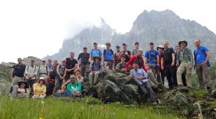
Traditional field studies have often been conducted by individuals or only small groups of researchers. One fundamental aspect of this project, termed the ExTerra Field Institute and Research Endeavour (or E-FIRE for short) was to conduct collaborative fieldwork to collect materials held communally, foster broad interactions through workshops, and incorporate student exchanges among research laboratories. The E-FIRE group consisted of researchers (including seven PhD students and three postdocs) from nine U.S.-based universities and research institutions, each with different analytical expertise in metamorphic petrology and geochemistry (e.g. stable isotopes, geochronology, thermodynamic modeling).

In addition, ExTerra partnered with a sister European organization, the ZIP project (Zooming In between Plates). The ZIP project, coordinated by Philippe Agard, consists of researchers from twelve universities across Europe with support from a number of different industry partners. The project has been running since 2013, with many of the twelve PhD students being in the final stage of their projects when we arrived in the field this summer.

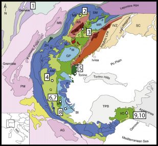
The overall big picture of this project was to trace the cycle of rocks and fluids through the subduction process. For this, we proposed to go to the Earth’s premier example of a fossil subduction zone – the Western Alps, Europe in the summer of 2017.

Planning and logistics

Weekly Google Hangouts offered the early stage researchers an opportunity to discuss papers on Western Alps geology and conduct webinars on analytical techniques, modeling, and field observation. In addition, an important component of the E-FIRE initiative was to have open, collaborative documentation and data sharing, with the end goal of opening the complete sample and data collection to any future researchers interested in subduction zone research. Hangout sessions before fieldwork included discussion with Frank Spear about the use of MetPetDB (a global database of various metamorphic petrology data) and with members of SESAR (System for Earth System Registration) about utilizing International Geo Sample Numbers (IGSNs – unique numbers and barcodes given to each sample).

One of the first major steps in the E-FIRE project was the first joint E-FIRE-ZIP workshop/retreat held in the Marin Headlands, close to San Francisco, in December 2016. This was the first time many of us had met in person. It provided a great opportunity for everyone to get to know each other. We also got to see some of our first subduction zone rocks together during a mini fieldtrip to nearby outcrops of eclogites and blueschists of the Franciscan Complex. It was also exciting to have such a large group of young researchers, from across North America and Europe!
Much of the credit for the fieldwork planning and organization must go to the E-FIRE PI triumvirate of Matt Kohn, Maureen Feineman, and Sarah Penniston-Dorland, as well as our main European collaborators Philippe Agard, Marco Scambelluri, Othmar Müntener, Samuel Angiboust, and their students.

E-FIRE Group Fieldwork overview – 7/26/17 – 8/6/17

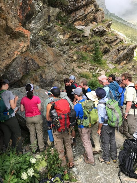
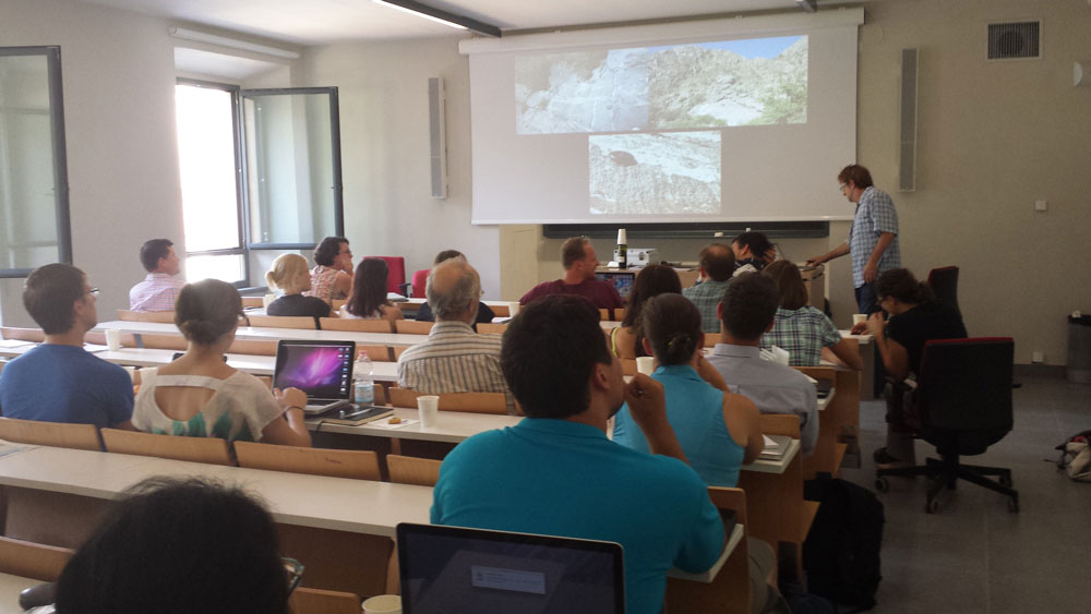
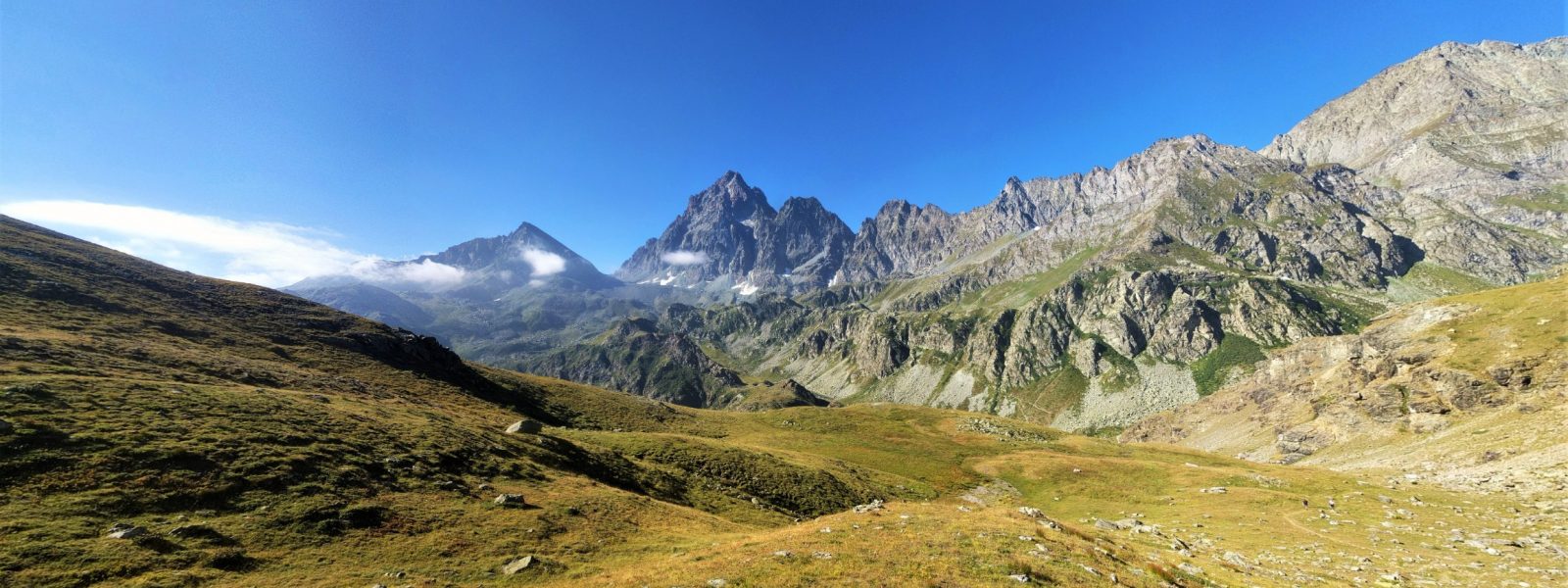
This would turn out to be a different field experience for many of us. At any one time, there were 25-30 of us in the group, including our European collaborators. For a majority of the time, we stayed in Italian hostels and rifugios with beautiful mountain vistas (I know what you’re thinking…rough stuff). Thankfully, it just so happens that many of the world’s premier metamorphic rocks are associated with many of the Alp’s premier mountains: the Matterhorn, the Dent Blanche, and Monviso. Lunchtime in the field would often consist of grab bags of breads, cheeses, and cured meats from the local market (don’t worry, we ate some fruits and vegetables).

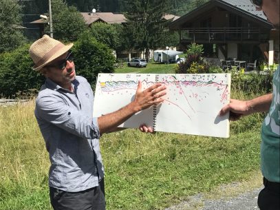
After a few close scares with delayed flights, everyone arrived safely in time for our first group E-FIRE dinner in Geneva. The next morning, we headed off for our first day in the field, consisting of an introduction to Alpine geology with rapid-fire stops along the way driving from Geneva to the Aosta Valley in Italy. This part of the trip was led by Alpine geology maestro, Philippe Agard, who demonstrated an incredible ability to explain complex Alpine features whilst hand-drawing cross-sections in front of some fantastic Alpine vistas.

No trip to the Alps would be complete without a hard slog up some steep mountainous terrain and our second day in the field delivered just that! Having hiked up some 1200 m of relief (most of us still suffering from jetlag), we were rewarded with spectacular views and some equally exciting geology in the Dent Blanche area. This area is interpreted to be a well-exposed example of an ancient subduction interface, where continental material of the colliding overlying plate is juxtaposed against the lower plate of European affinity. Recent work by some of our European collaborators, led by Samuel Angiboust, has suggested that this could be one of the best natural analogues for a subduction zone interface near the base of the upper plate crust.

Our third day started with an immaculate view of Monte Cervino (or it’s more well-known German name, Matterhorn). A beautiful mountain-side trail took us up to Lago Di Cignana, an artificial lake located in Valtournenche, in the Aosta Valley. This site is most well known as an ultra-high pressure (UHP) locality, consisting of various coesite (high-pressure polymorph of quartz)-bearing eclogites and schists. Recent work has found evidence for micro-diamonds within fluid inclusions in garnet, suggesting that these rocks were buried to depths greater tha 100 km and potentially provide a unique record of processes occurring deep within the subduction zone.

The next day consisted of a transect across the Schistes Lustres – one of the most complete sections across a fossil accretionary wedge complex consisting of blueschist and eclogite facies metasediments. The fieldwork was punctuated by brief outbursts of some stormy Alpine weather (thankfully one of the only rainy days in the whole trip!).

Day 5 featured a trip to the Lanzo Massif and a shift in focus from the processes operating during Alpine orogenesis to those occurring on the seafloor, prior to subduction. In contrast to many of the Alpine ophiolites seen on this fieldtrip, the Lanzo Massif has largely escaped metamorphic overprinting. Our leader for this day, Othmar Muntener, showed us well-preserved examples of seafloor serpentinisation and discussed the evidence for Lanzo, and some other Alpine ophiolites, belonging to an ultra-slow spreading ridge system. Of particular interest to the group was discussion of evidence for subducted sub-continental lithospheric mantle that would have been exhumed to the seafloor along large-scale detachment faults as part of a slow-spreading ridge system.

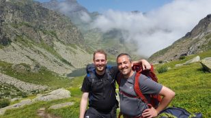
For many of us, one of the highlights on the trip was the Monviso area, in the Italian Alps. The two-day trip featured a tour around one of the best exposed fragments of subducted oceanic material, interpreted as a coherent slice of the oceanic crust/mantle interface. Whilst the hiking around the area featured some fantastic vistas of Monviso and the adjacent peaks, it was perhaps equally memorable for the dense clouds that would appear out of nowhere and reduce the visibility to just a few meters. Perhaps unsurprisingly, given a group of thirty geologists easily distracted by the rocks, we managed to lose some of the group in the fog! After about a thirty-minute search, and a lot of shouting and whistling, the lost E-FIRE folks were located – already on their way to the Rifugio for an early happy hour.

After the Monviso trip, we took a field break to decompress and to discuss the nascent project ideas the students and postdocs were thinking about in the context of the sites we had visited. It was exciting to hear students bouncing ideas off each other and contemplating how each of their individual projects goals will tie into each other’s. We smell collaboration (and field boots)!
After a well-needed day of rest and relaxation, we drove east to the Ligurian Alps, with the port city of Genoa as our base of operations over the next three days. Here, we drove north, as the serpentinite guru, Marco Scambelluri, led us into the Voltri Massif. In this portion of the Western Alps, it is suggested that convergence between Europe and Apulia occurred at an ocean-ocean plate interface (as opposed to northwest at Monviso, which is suggested to be ocean-continent). We got to contemplate whether changes in plate dynamics here would have resulted in differing metamorphic conditions and preservation of buried lithologies. Our first day was an introduction to the regional geology, and a quick introduction to fieldwork closer to the Mediterranean, with temperatures at times in excess of 100˚F. Much of the terrane is heavily vegetated, so the best field exposures were in riverbeds, like those of the Gorzente River, in the Erro Tobio Unit. The Erro Tobio Unit consists of variably serpentinized ultramafic rocks, with the most striking feature in these rocks being coalescing veins of metamorphic olivine resulting from dehydration during subduction.

The next day, Marco led us to several roadside locations in the Beguia Unit of the Voltri Massif, a region of large (tens to hundreds of meters) lenses of metamorphosed gabbro in a matrix of serpentinite. It has been hypothesized that these lenses may represent a tectonic mélange or simply an extension of what we all observed earlier in the trip. The temperature that day did not let up, and hammering dense Fe-Ti meta-gabbros did not provide a break either (pun intended), but we collected some spectacular samples and witnessed Marco’s expert wielding of a sledge hammer. At the end of days like this, a cool refreshment is always welcome, as well as a nice stroll along the rocky coast of Genoa.

Small Group Fieldwork | 8/8/17 – 8/28/17

Groups of researchers went back to Monviso to collect more stunning examples of slab/mantle fluid-rock interaction, to Dent Blanche for finer-scale sampling of the subduction interface, and out by ferry to explore an extension of the high-pressure Western Alpine rock in Corsica. The authors, with a group of others, went back to the Voltri Massif for more sampling of meta-gabbros and serpentinites, but also to the Apennines, where relics of unsubducted gabbro and serpentinite are preserved. There, we experienced two firsts: tripe (with mixed responses!), and having the carabinieri (the Italian military police) called on us for hammering rocks. This time with smaller groups going back to some of the same locations we visited earlier in the trip, the focus was on more detailed sampling for individual project goals, and expanded discussion of field observations and any tectonic interpretations.

After several days in smaller teams, the E-FIRE group was re-assembled back in Geneva, Switzerland for one more day, and what could possibly beat the adventures we experienced in the field? Why, it’s sample packing! In a parking lot at the Université de Lausanne, we showed each other some of the rocks we collected for our projects, and in some cases, samples we set out to collect for each other’s projects. Samples were packed onto a pallet and wrapped like no rocks had ever been wrapped before. That night, we had one final group dinner in Geneva before we all split up again, where many were back out into field and others were off to the Goldschmidt conference in Paris.

All told, roughly 700 kg of rock was collected by the E-FIRE group during the field excursion, and shipped to Penn State University where the samples will be held in a sample repository. This is of course until we crush, pick at, dissolve, and shoot lasers at them. In all seriousness, it is safe to state that the 2017 ExTerra Field Institute and Research Endeavour was the experience of a lifetime, especially for the early stage researchers; a unique opportunity to interact and initiate collaborations with each other and our new European colleagues, observe and contemplate subduction zone processes in a classic field location, and travel through one of the most beautiful terranes on Earth.

Acknowledgments

We are grateful to Philippe Agard, Marco Scambelluri, Othmar Müntener, and Samuel Angiboust (along with other European students, postdocs, and research scientists) for their guidance in field logistics and immense knowledge of Western Alps geology. We would like to thank the principal investigators Matt Kohn, Sarah Penniston-Dorland, and Maureen Feineman for the leadership and organizational skills necessary for such a large field-based research endeavor. We finally thank W.O. Bargone for field assistance. This field institute was supported by NSF EAR-1545903 and readers like you. ■
“Report from the Field” was designed to inform the community of real-time, exciting GeoPRISMS -related research. Through this report, the authors expose the excitement, trials, and opportunities to conduct fieldwork, as well as the challenges they may have experienced by deploying research activities in unique geological settings. If you would like to contribute to this series and share your experience on the field, please contact the GeoPRISMS Office at info@geoprisms.nineplanetsllc.com. This opportunity is open to anyone engaged in GeoPRISMS research, from senior researchers to undergraduate students.
We hope to hear from you!

Reference information
ExTerra Field Institute and Research Endeavor: Western Alps, Summer 2017. B. Dragovic, P. Starr
GeoPRISMS Newsletter, Issue No. 39, Fall 2017. Retrieved from http://geoprisms.nineplanetsllc.com

Imaging the Nicaragua Subduction Zone with Marine Electromagnetic Methods


Samer Naif1, Kerry Key1, Steven Constable1, Rob L. Evans2
1SCRIPPS Institution of Oceanography, 2Woods Hole Oceanographic Institute

Modified from Naif, S., Key, K., Constable, S., Evans, R.L., 2013. Melt-rich channel observed at the lithosphere-asthenosphere boundary. Nature 495, 356-359.

In April and May 2010, we conducted the Serpentinite, Extension and Regional Porosity Experiment across the Nicaraguan Trench (SERPENT). During the 28 day cruise on the R/V Melville we collected seafloor electromagnetic data sensitive to electrical conductivity variations in the crust and mantle. Because electrical conductivity depends on pore fluid content, the data from SERPENT provide unique constraints on porosity across an active subduction zone. The entire SERPENT data set consists of 54 stations of marine magnetotelluric (MT) data and nearly 800 km of deep-towed controlled-source electromagnetic (CSEM) data. This is a huge milestone for marine electromagnetic (EM) studies as we collected significantly more seafloor MT stations than previous offshore surveys of subduction zones. Furthermore, our survey is the first to collect marine CSEM data at a subduction zone. The results showed here demonstrate the ability to image porosity and pore fluids in crustal bending faults and along the plate interface beneath the forearc using this technique.

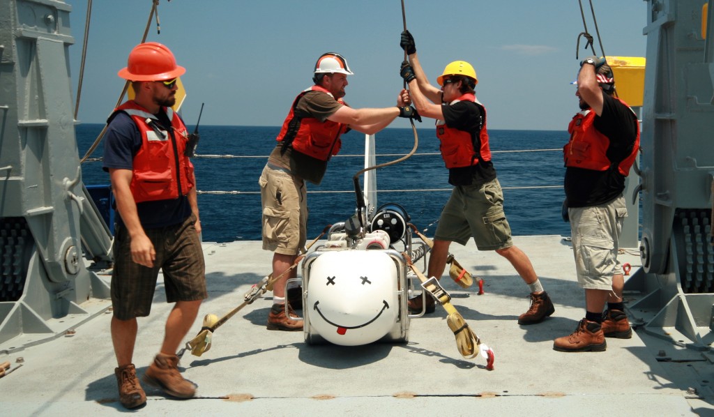
SERPENT team members deploy the Scripps Undersea EM Source Instrument (SUESI), a deep-towed horizontal electric dipole transmitter used for the CSEM method. SUESI will only work if she is smiling.

SERPENT team members deploy the Scripps Undersea EM Source Instrument (SUESI), a deep-towed horizontal electric dipole transmitter used for the CSEM method. SUESI will only work if she is smiling.

Electrical conductivity is a material property that can vary by several orders of magnitude in geologic systems. While metallic ore bodies can be very conductive, the silicate rocks that dominate the crust and upper mantle are relatively poor conductors (<10-5 S/m). However, fluids such as seawater and basaltic melt are significantly more conductive (>10-1 S/m). Given this large contrast, even small amounts of conductive pore fluids in an otherwise resistive matrix can produce a notable increase in bulk electrical conductivity, making a suitable target for EM exploration.

Electrical and electromagnetic (EM) methods have been used for onshore prospecting for about a century. Their use offshore came later with pioneering efforts at the Scripps Institution of Oceanography, where an ocean-bottom EM recorder was developed in the 1960’s , followed by the development of a deep-towed EM transmitter system in the 1970’s and 1980’s to map the high resistivity of the oceanic lithosphere (Constable, 2013). While this early work was largely funded by the Office of Naval Research, the recognition that this technology could be used to map resistive hydrocarbon reservoirs on the continental shelves led to a significant influx of industry support starting around 2000, resulting in major strides in instrumentation design, numerical modeling algorithms, and data interpretation tools. In particular, industry support allowed Scripps to develop a fleet of 60 broadband ocean-bottom EM receivers and two deep-towed EM transmitter systems. We leveraged this equipment for the NSF-funded SERPENT project, resulting in the largest marine EM experiment at a subduction zone to date.

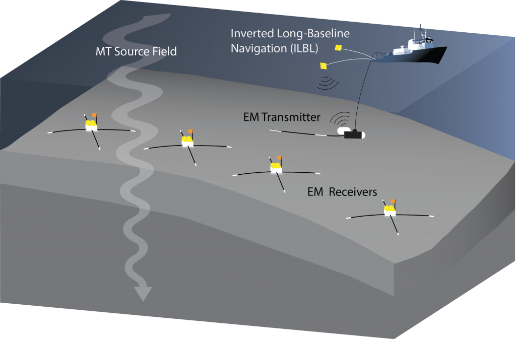
MT passive method utilizes a natural source field generated by the interaction of the solar wind with the geomagnetic field. This interaction leads to the formation of time varying ionospheric current systems that emanate plane EM waves diffusing down to the surface through the resistive atmosphere. As these EM fields diffuse into the solid Earth, they attenuate in response to the subsurface conductivity structure. By measuring both electric and magnetic fields on the seafloor for several days to weeks, the MT method can estimate frequency dependent impedances over several decades of frequency, which in turn can be inverted for conductivity structure. In marine environments, the highly conductive ocean attenuates the source energy at frequencies above about 0.1 Hz, reducing the sensitivity of marine MT to shallow structure and making it more suitable for recovering upper mantle conductivity structure. In order to better resolve structure in the upper 10 km, we can supplement the MT method with the CSEM method, which involves deep towing a transmitter that emits 300 amps of time varying current across a 250 m dipole antenna, giving EM responses in the 0.25 to 10 Hz band (Fig. 1).

Figure 1. Marine EM survey operations. Broadband EM receivers are deployed from the ship to record electric and magnetic fields generated by both active and passive sources. An EM transmitter, deep-towed behind the ship near the seafloor, emits the high-frequency active source energy. The transmitter position is acoustically navigated with an inverted long-baseline configuration. A large-scale survey spanning several hundred kms can be performed in a single month long cruise voyage.

Figure 1. Marine EM survey operations. Broadband EM receivers are deployed from the ship to record electric and magnetic fields generated by both active and passive sources. An EM transmitter, deep-towed behind the ship near the seafloor, emits the high-frequency active source energy. The transmitter position is acoustically navigated with an inverted long-baseline configuration. A large-scale survey spanning several hundred kms can be performed in a single month long cruise voyage.

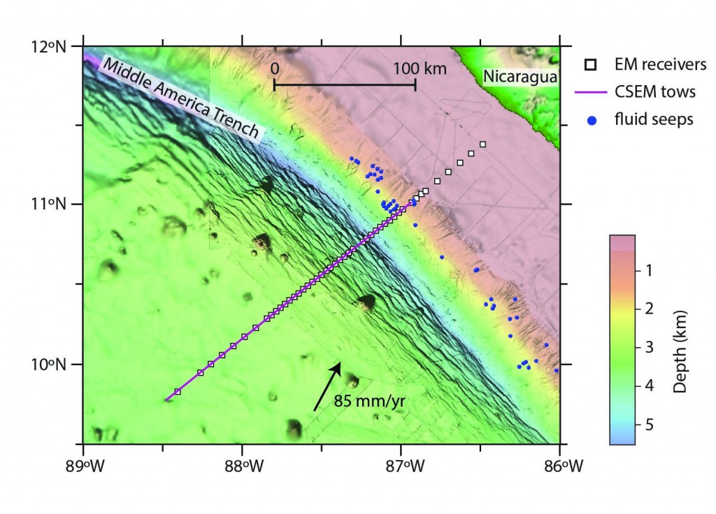
The SERPENT survey was conducted along a 280-km transect crossing the Middle America Trench offshore Nicaragua (Fig. 2). Previous seismic imaging detected deep Moho-crossing bending faults that could provide pathways for water to serpentinize the uppermost mantle (Ranero et al., 2003). We collected marine MT and CSEM data in order to probe the subsurface electrical conductivity structure for anomalies associated with fluid-tectonic processes at the subduction front, such as plate hydration beneath the outer rise bending faults as well as diagenetic dehydration of the subducted sediments. Our goal was to quantify the lateral and depth variations of porosity in the incoming oceanic plate and the forearc margin so that we could infer fluid content and identify migration pathways and circulation patterns.

Figure 2. Map of the SERPENT survey transect. A total of 50 EM receivers were deployed across the Middle America Trench offshore Nicaragua, where the 24 Ma Cocos plate subducts beneath the Caribbean plate. Receiver locations spanned the abyssal plain, the visibly faulted outer rise, and the continental slope and shelf at 10 and 4 km spacing. A cluster of active forearc seeps are located adjacent to the survey transect (blue circles).

Figure 2. Map of the SERPENT survey transect. A total of 50 EM receivers were deployed across the Middle America Trench offshore Nicaragua, where the 24 Ma Cocos plate subducts beneath the Caribbean plate. Receiver locations spanned the abyssal plain, the visibly faulted outer rise, and the continental slope and shelf at 10 and 4 km spacing. A cluster of active forearc seeps are located adjacent to the survey transect (blue circles).

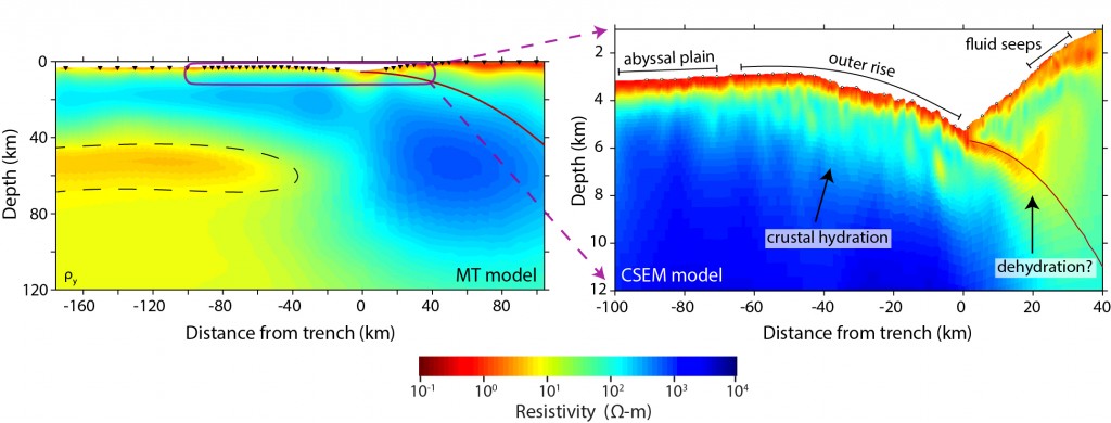
We specifically designed the survey transect to include data coverage over the Cocos plate abyssal plain, far enough seaward of the outer rise so we would image what was expected to be a simple one-dimensional conductivity structure of “normal” oceanic mantle. This measure was meant to serve as a background measurement of the oceanic lithosphere from which we could better quantify conductivity changes associated with faulting and hydration at the deformation front. With a stroke of luck, the MT data from the abyssal sites were far more valuable than we predicted, aiding our discovery of a surprising horizontally extensive high conductivity layer at depths of 45-70 km (Fig. 3). The observed layer led us to consider a fundamental question regarding plate tectonics that was unrelated to the originally proposed goals of the survey: what rheological mechanisms govern the lithosphere-asthenosphere boundary (LAB) allowing rigid tectonic plates to slide?

Figure 3. Non-linear 2D inversion of MT and CSEM data. Left: converged MT data inversion. The dashed black lines enclose the prominent low resistivity channel interpreted as partial melt at the LAB. Right: converged CSEM data inversion that shows decreasing resistivity beneath fault scarps at the outer rise and a low resistivity channel that follows the plate interface in the forearc margin, and which represent hydration and sediment subduction, respectively.

Figure 3. Non-linear 2D inversion of MT and CSEM data. Left: converged MT data inversion. The dashed black lines enclose the prominent low resistivity channel interpreted as partial melt at the LAB. Right: converged CSEM data inversion that shows decreasing resistivity beneath fault scarps at the outer rise and a low resistivity channel that follows the plate interface in the forearc margin, and which represent hydration and sediment subduction, respectively.

There are three competing hypotheses often invoked to explain the oceanic LAB that is prominent in seismic and EM observations: 1) a thermal boundary, 2) a hydration boundary, 3) a partial melt boundary (Fischer et al., 2010). From the existing laboratory studies of the electrical conductivity of expected mantle phases, the signature of our observed channel is too conductive to be explained with either temperature or hydrated olivine alone. Such high conductivity measurements require an interconnected network of 1-2% hydrated basaltic melt. Alternatively, a recent study suggests that 0.3-0.5% of highly enriched incipient melt is a more plausible interpretation (Sifré et al., 2014). In light of other recent results that infer or are compatible with partial melt at the LAB (Mierdel et al, 2007; Sakamaki et al., 2013; Yamamoto et al., 2014) it is tempting to conclude that partial melts are ubiquitous and the dominant cause of a rheologically weak asthenosphere. However, a number of competing interpretations derived from compelling observations continue to spark exciting debate regarding the origin of the asthenosphere (Karato, 2012; Beghein et al., 2014; and references therein).

While the MT results are enticing food for thought, we have yet to address our survey’s core objective, to investigate the hydration and dehydration of a subducting slab. This is where the potential of the CSEM method really shines. In the right panel of figure 3, we offer a glimpse of our 2D CSEM conductivity model, created by a non-linear two-dimensional inversion of the observed data (Naif et al., in review). This model depicts three important fluid-tectonic processes within the framework of a single coherent image:

At the outer rise, multiple sub-vertical conductive channels correlate with seafloor fault scarps that extend into the lower crust. This observation confirms previous conjecture that outer rise faults behave as porous permeable pathways for seawater to penetrate the plate and further suggests that significantly more crustal pore water is subducted than previously thought.

At the forearc, a thin conductive channel that persists along the plate-interface is caused by the complete subduction of porous sediments with the sinking oceanic plate. This observation suggests that a considerable amount of water is available to generate extreme pore pressures and is consistent with seismic observations and numerical models at the erosive Nicaraguan margin (Spinelli et al., 2006; Ranero et al., 2008; Saffer & Tobin, 2011).

Approximately 20 km into the margin, a prominent sub-vertical conductive channel propagates from the plate-interface into the overlying continental crust in the same region where numerous active seafloor seeps and mud mounds exist (Sahling et al., 2008). This is potentially the first observation to image the migration of subducted fluids to forearc vents.

The outcomes of the SERPENT survey we described above may signify a new era for marine EM exploration that is well suited for the study of fluid-tectonic processes. The interpretation of our conductivity models in terms of faulting and fluid processes builds upon an abundance of geophysical, geochemical, and geological research focused on the Nicaragua and Costa Rica region, testifying to the critical advantages that collaborative multidisciplinary efforts have to offer.

References
Beghein, C., Yuan, K., Schmerr, N., Xing, Z. (2014). Changes in seismic anisotropy shed light on the nature of the Gutenberg Discontinuity. Science, 343(6176), 1237–1240.
Constable, S. (2013). Review paper: Instrumentation for marine magnetotelluric and controlled source electromagnetic sounding. Geophys. Prospect., 61(s1), 505–532.
Fischer, K.M., Ford, H., Abt, D., Rychert, C.A. (2010). The lithosphere-asthenosphere boundary. Annu. Rev. Earth Planet. Sci., 38, 551–575.
Karato, S. (2012). On the origin of the asthenosphere. Earth Planet. Sci. Lett., 321, 95–103.
Mierdel, K., Keppler, H., Smyth, J.R., Langenhorst, F. (2007). Water solubility in aluminous orthopyroxene and the origin of Earth’s asthenosphere. Science, 315(5810), 364–368.
Ranero, C. R., Grevemeyer, I., Sahling, H., Barckhausen, U., Hensen, C., Wallmann, K., et al. (2008). Hydrogeological system of erosional convergent margins and its influence on tectonics and interplate seismogenesis. Geochem. Geophys. Geosys., 9(3).
Ranero, C.R., Phipps Morgan, J., McIntosh, K., Reichert, C. (2003). Bending-related faulting and mantle serpentinization at the Middle America trench. Nature, 425(6956), 367–373.
Saffer, D.M., Tobin, H.J. (2011). Hydrogeology and Mechanics of Subduction Zone Forearcs: Fluid Flow and Pore Pressure. Annu. Rev. Earth Planet. Sci., 39(1), 157–186.
Sahling, H., Masson, D.G., Ranero, C.R., Hühnerbach, V., Weinrebe, W., et al. (2008). Fluid seepage at the continental margin offshore Costa Rica and southern Nicaragua. Geochem. Geophys. Geosys., 9(5).
Sakamaki, T., Suzuki, A., Ohtani, E., Terasaki, H., Urakawa, S., Katayama, Y., et al. (2013). Ponded melt at the boundary between the lithosphere and asthenosphere. Nat. Geosci., 6(11), 1–4.
Sifré, D., Gardés, E., Massuyeau, M., Hashim, L., Hier-Majumder, S., Gaillard, F. (2014). Electrical conductivity during incipient melting in the oceanic low-velocity zone. Nature, 509(7498), 81–85.
Spinelli, G.A., Saffer, D.M., Underwood, M.B. (2006). Hydrogeologic responses to three-dimensional temperature variability, Costa Rica subduction margin. J. Geophys. Res., 111(B4).
Yamamoto, J., Korenaga, J., Hirano, N., Kagi, H. (2014). Melt-rich lithosphere-asthenosphere boundary inferred from petit-spot volcanoes. Geology, G35944.1.Benoit, M.H., Long, M.D. (2009). The TEENA experiment: a pilot project to study the structure and dynamics of the eastern US continental margin: AGU Fall Meeting Abstracts.

Reference information
Imaging the Nicaragua Subduction Zone with Marine Electromagnetic Methods, Naif, S., Key, K., Constable, S., Evans, R.L.
GeoPRISMS Newsletter, Issue No. 33, Fall 2014. Retrieved from http://geoprisms.nineplanetsllc.com

Report on GeoPRISMS Mini-Workshop at Fall 2011 AGU – “Using Geoinformatics Resources to Explore the Generation of Convergent Margin Magmas”


AGU Fall Meeting 2011, San Francisco

R. Stern1, M. Feigenson2, K. Lehnert3, A. Goodwillie3, P. van Keken4, J. Kimura5, B. Dreyer6, E. Jordan1,  W. Lieu1

1University of Texas, Dallas; 2Rutgers University; 3Lamont-Doherty Earth Observatory; 4University of Michigan; 5IFREE, JAMSTEC; 6University of California, Santa Cruz

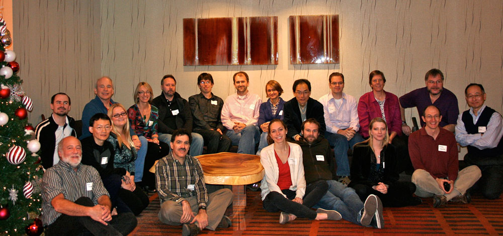
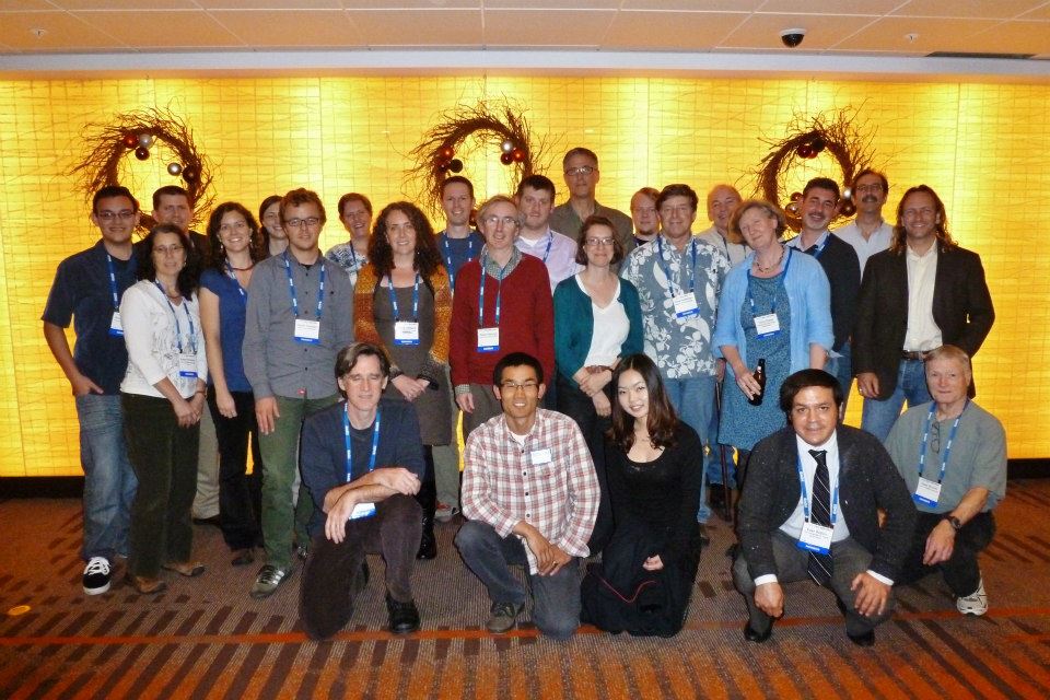
Figure 1. Dec. 2011 GeoPRISMS geoinformatics workshop participants. Front row (L to R): M. Feigenson, Warren Lieu, Erika Jordan, Peter Michael, Megan Derrico, Nick Deems, Sara Douglas, Andrew Goodwillie, Jun-ichi Kimura. Back row: Charles Bopp, Bob Stern, Kerstin Lehnert, Guillaume Girard, Tyrone Rooney, Katherina Vogt, Osamu Ishizuka, Brian Dreyer, Julia Morgan, Peter van Keken

Figure 1. Dec. 2011 GeoPRISMS geoinformatics workshop participants. Front row (L to R): M. Feigenson, Warren Lieu, Erika Jordan, Peter Michael, Megan Derrico, Nick Deems, Sara Douglas, Andrew Goodwillie, Jun-ichi Kimura. Back row: Charles Bopp, Bob Stern, Kerstin Lehnert, Guillaume Girard, Tyrone Rooney, Katherina Vogt, Osamu Ishizuka, Brian Dreyer, Julia Morgan, Peter van Keken

Twenty geoscientists attending Fall AGU forsook the chance to enjoy a beautiful Sunday in San Francisco on December 4, 2011, and chose instead to descend into the bowels of the Grand Hyatt for the chance to explore how geoinformatics can help geoscientists understand the composition and generation of convergent margin magmas. The all-day workshop was organized in support of the science goals of the GeoPRISMS Subduction Cycles and Deformation (SCD) Initiative. SCD aims to understand how subduction zones work, from cold, shallow regimes (accretionary prism, forearc crust, and the seismogenic zone) to deeper, hotter regions where fluids and melts from the subducted slab trigger melting in the convecting asthenosphere above it. SCD builds on and integrates the successes of the predecessor MARGINS Seismogenic Zone and Subduction Factory experiments, targeting the Aleutian and Cascade arcs as community-chosen focus sites. The techniques and insights developed from studies of these arcs can be applied globally, and we hope to attract more geoscientists to join the “subduction parade”. In our efforts to involve a more diverse group of geoscientists in this effort – from students to university professors to expert researchers – we need to develop better, more accessible tools for this community to use. The Geoinformatics workshop was an effort to attract new members of the GeoPRISMS SCD team and help prepare these geoscientists.

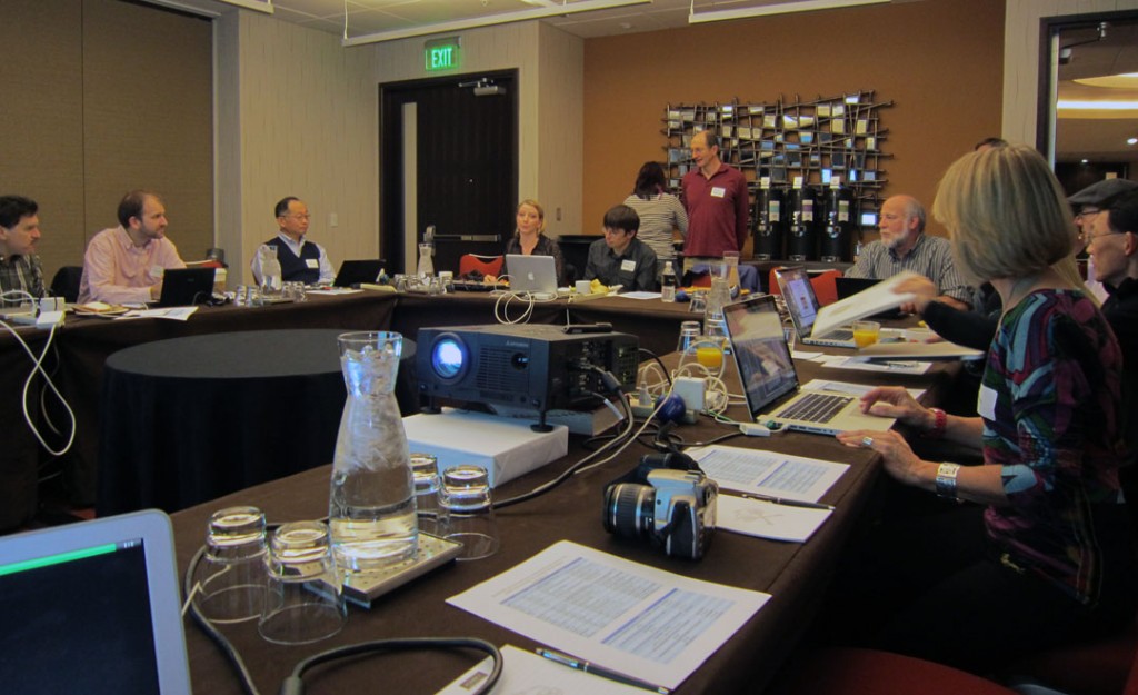
Figure 2: Dec. 2011 GeoPRISMS Geoinformatics Workshop in action. Andrew Goodwillie explains GeoMapApp to workshop participants

Figure 2. Dec. 2011 GeoPRISMS Geoinformatics Workshop in action. Andrew Goodwillie explains GeoMapApp to workshop participants

These are lofty goals that can only be realized if interested geoscientists gather to explore effective tools and how they can be used. The most important community tools are databases, data visualizations, and data analysis software. Examples of each of these were highlighted in the workshop, as is clear from the agenda below (with pertinent links and other information). Each 50 minute long session encouraged questions and comments from workshop participants and was followed by a 10-minute break that allowed folks to stretch and refuel with plenty of food and beverages provided by GeoPRISMS.

  1. Geochemical databases and how to access them – Kerstin Lehnert (LDEO) explained how geochemical databases such as PetDB, Georoc, SedDB, and NAVDAT (all of which can be accessed via Earthchem) are increasingly important aspects of teaching and research (including GeoPRISMS SCD). Kerstin also explained how the new SESAR (System for Earth Sample Registration) can resolve problems of sample ambiguity (for example: how many samples have the same ID, e.g., how many “D1” samples are there in dredge collections around the world?) and data redundancy (for example: how many samples have been analyzed multiple times for different elements and isotopes, each reported with slightly different IDs that are entered separately into one or more databases?). Kerstin emphasized how important it was that samples studied as a result of GeoPRISMS SCD should each be registered for(International Geo Sample Number), a 9-digit alphanumeric code that uniquely identifies samples and provides information about where these can be found.
  2. Data Visualization Tool: GeoMapApp – GeoMapApp is an Earth science exploration and visualization application that is maintained and improved as part of the Marine Geoscience Data System at LDEO. There are several YouTube GeoMapApp multimedia tutorials that can be accessed. Of special interest to this workshop is the fact that GeoMapApp has a new feature that allows users to determine the depth of the subducted slab beneath a given arc volcano, and one tutorial shows how to do this, using the global compilations of Syracuse and Abers (2006).
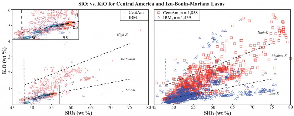
  3. Central America and Izu-Bonin-Mariana arc geochemical databases – Erika Jordan and Warren Lieu (UT Dallas). CentAm and IBM were focus sites for the MARGINS Subduction Factory experiment and geochemical data for these from EarthChem have been compiled and are being filtered so that these can be made available as an Earthchem data library. Erika summarized the status of compilations for volcanic front lavas from these two focus sites, using graphs to show their geochemical similarities and differences. Once completed, these compilations will be available to anyone as a Geochemical Reference Library. One of the important issues related to such compilations is how to best show these data. There are hundreds to thousands of data points in these compilations, so individual points on graphs often lie on top of each other and it can be difficult to see underlying structure. Warren showed how large data sets can be contoured and it is clear that making such data visualization tools available will be key for exploiting large geochemical data sets.
  4. Thermal structure of subducted slabs – Modeling the thermal structure of subduction zones and using geochemical and geophysical data to test and refine these models is leading to some of the most rewarding collaborations between geodynamic modelers, geophysicists, and geochemists. After lunch, Peter van Keken (U. Michigan) presented some of the latest thinking about how lithosphere age and convergence rate control temperatures in subduction zones. It is the slightly (~1%) more dense nature of the ~100 km thick lithosphere relative to ambient mantle that makes plates subduct, but it is the thin veneer of subducted sediments and the upper, altered portion of the oceanic crust– typically only a few tenths of a percent of everything that is subducted – that controls the subduction zone incompatible element budget. We cannot understand the trace element and isotopic composition of arc lavas without understanding how sediments are cooked in the subduction zone kitchen. Subducted sediments lie athwart a very strong temperature gradient between hot convecting asthenosphere and cool conducting lithosphere, so it is not surprising that our thinking has fluctuated between a consensus that subducted sediments beneath the arc mostly are sufficiently cool that they only release hydrous fluids to the idea that they are mostly hot enough to melt. Thermal models for subducted sediments need to be tested and refined with geophysical and geochemical data and experiments.
  5. Introduction to Arc Basalt Simulator 3.1 – Jun-ichi Kimura (JAMSTEC/IFREE) presented the theoretical underpinnings of an evolving software package for understanding arc petrogenesis, called “Arc Basalt Simulator”, or “ABS”. ABS is a forward model designed to match the incompatible trace element and radiogenic isotopic composition of primitive (high Mg#) arc lava by inputting appropriate subducted sediment and altered oceanic crust compositions and compositions of unmodified mantle wedge, choosing an appropriate subduction zone thermal model (from Syracuse et al., 2010) and adjusting some other subduction zone parameters, such as where fluids or melts are extracted from the downgoing slab and the depth of mantle melting. ABS is an Excel-based spreadsheet that can be run on any PC or Mac, so all members of the GeoPRISMS SCD community can use it. A tutorial walks the new user through the various functions of ABS 3.1. The ABS spreadsheet and ABS tutorial can be downloaded from the Geochemical Resource Library. A recent paper (Kimura et al., 2010) uses ABS version 3.1 to investigate compositions of primitive magmas along the Izu arc, and a new version (ABS 4) is being developed by Dr. Kimura and colleagues.
  6. ABS exercise – Bob Stern (UTD) and Mark Feigenson (Rutgers) provided some practical experience with ABS3.1. Bob walked workshop participants through each of the ABS3.1 user-adjustable functions, then Mark showed the group how ABS 3.1 could be used to understand the composition of primitive Cerro Negro (Nicaragua) lavas.
Fig3_geoinfo_s2012

Figure 3. Two different ways to present large compilation geochemical datasets for volcanic rocks from the magmatic fronts of MARGINS Subduction Factory focus sites in Central America (CentAm, red, n=1,058) and Izu-Bonin-Mariana (IBM, blue, n=1,439), using K2O vs. SiO2 as an example. Most Central American lavas have higher K2O contents at a given SiO2 content than most Izu-Bonin-Mariana samples. Left panel presents contoured data, right panel shows individual data points. Contoured data draws attention to where data are concentrated, plots of individual data draws attention to outliers

There are some useful lessons to be learned for others considering proposing future workshops before or after national geoscientific meetings like AGU or GSA. It is important to start planning early so that possible participants have the workshop on their “radar screens” before they buy their air tickets for the meeting, and so these societies can include the workshops on meeting announcements. In addition, workshop conveners should make a strong push to advertise the workshop at least two months before the meeting, in order to maximize workshop attendance. The conveners would be happy to discuss other considerations with people thinking about proposing a GeoPRISMS workshop.

 icon-chevron-right Go to the mini-workshop webpage

References

Kimura, J.-I., Kent, A.J.R., Rowe, M.C., Katskuse, M., Nakano, F., B. R. Hacker, P. E. van Keken, H. Kawabata, and R. J. Stern, 2010. Origin of cross-chain geochemical variation in Quaternary lavas from the northern Izu arc: Using a quantitative mass balance approach to identify mantle sources and mantle wedge processes. Geochemistry, Geophysics, Geosystems 11, Q10011, doi:10.1029/2010GC003050

Syracuse, E.M., Abers, G.A., 2006. Global compilation of variations in slab depth beneath arc volcanoes and implications. Geochem. Geophys. Geosyst. 7, Q05017, doi:10.1029/2005GC001045.

Syracuse, E. M., van Keken, P.E., and Abers, G.A., 2010. The global range of subduction zone thermal models, Physics of the Earth and Planetary Interiors 183, 73-90. doi:10.1016/j.pepi.2010.1002.1004

Reference information

Report on GeoPRISMS Mini-Workshop at Fall 2011 AGU – “Using Geoinformatics Resources to Explore the Generation of Convergent Margin Magmas”, Stern B, et al;

GeoPRISMS Newsletter, Issue No. 28, Spring 2012. Retrieved from http://geoprisms.nineplanetsllc.com

R/V Marcus Langseth Cruise to the Mariana Trench: February 2-29, 2012 Large Scale Active/Passive Source Seismic Experiment


John Lundquist (WHOI), Foreword by Doug Wiens (Washington University at St. Louis)

How much water is transported deep into the Earth at subduction zones, locked away as hydrous minerals in the downgoing oceanic mantle? This question is vital for understanding the source of water erupted at island arc volcanoes as well as determining whether significant water is carried deeper to the transition zone.

A pair of cruises sailed in early 2012 near the Mariana trench to help provide answers to these questions. The project, under the direction of Doug Wiens (Washington University in Saint Louis) and Dan Lizarralde (Woods Hole Oceanographic Institution), involved deploying 85 ocean bottom seismographs (OBS) from the R/V Thompson and seismic refraction and reflection imaging work carried out using the R/V Langseth airgun array.

The active source results will constrain the seismic velocity, and thus the degree of serpentinization, of the uppermost mantle thought to be occurring at faults associated with the bending of the Pacific plate near the trench. 25 OBSs remain deployed and will provide constraints on the maximum depth of serpentinization and catalog microearthquake activity on the bending faults. These OBSs will be recovered by the R/V Oceanus in January, 2013.

Seven graduate students participated in the two cruises. What is it like to go to sea on a seismic cruise for the first time? John Lundquist’s blog, from the Langseth cruise, provides some insight.

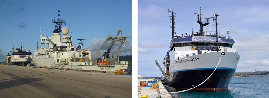
Figure 1. The two ships used for the Mariana seismic experiement:  (left) R/V Thomas G. Thompson, operated by the University of Washington; (above) R/V Marcus Langseth, operated by Columbia University.

Figure 1. The two ships used for the Mariana seismic experiement: (left) R/V Thomas G. Thompson, operated by the University of Washington; (above) R/V Marcus Langseth, operated by Columbia University.

Life at Sea: 8,653 miles, 4 airports, 3 inflight meals, and 34 hours later, I’m standing in the Hagåtña, Guam Airport. In my post trans world flight delirium “What the hell have I gotten myself into this time?” pops into my mind. I collect myself and step outside into the warm Pacific night air. A stark contrast from the artic chill I left in Maine. I arrive at the hotel…sweet, sweet sleep.

I wake up suddenly, unaware of where I am. A few hours of fitful rest hasn’t revived my senses or my mind. I look out the window and see surf breaking and the world starts to come back into focus. I’m John Lundquist….I know this….my next thought……go find someone in your group. I’m slightly anxious, as I’m about to rendezvous with a group of highly intellectual geophysicists, Ph.D. candidates, and graduate students. Having studied geology in college I should have felt prepared to meet these great minds. I walk down stairs and arrive at the breakfast buffet. As I scan the restaurant area, my gaze immediately rests on “the science” party….not too hard to pick out of a crowd. Nathan Miller, one of the chief scientists, walks up to me, “you must be John.” Apparently I wasn’t too hard to spot either. Introductions were made and the trip was underway.

We all piled into the rented mini-van for the Naval Base, where the ship was docked. We boarded the ship, were assigned our rooms, and then set free. We headed out for a few libations and our last taste of land before the 9AM departure time. The next day, as the ship cast off its lines, we all walked out to the Observation Deck. Pulling out of the harbor was beautiful. Guam’s mountainous landscape is breathtaking from the water. As we reach the end of the channel and transition into the open ocean, I quickly realized the ship is not stationary. Five minutes later…. seasickness…this is going to be a long month.

I begin my first shift as a watchstander by making my way down to the lab. I had briefly seen this area earlier, my first thought was “you could control the space shuttle from in here.” The lab is a complete floating technology hub, with about 40 computer monitors, countless processers, and Internet. From here everything science related is controlled and monitored. I was glad to finally get down there. As I sat down that first day, it was overwhelming to say the least. I had never been in a room with so many screens, let alone been put in charge of some of them. As a watchstander, we were basically assigned to monitor several scientific instruments. Every half hour, we entered data into a thirty-minute log. The function was to insure that all the instruments were still recording and running properly.

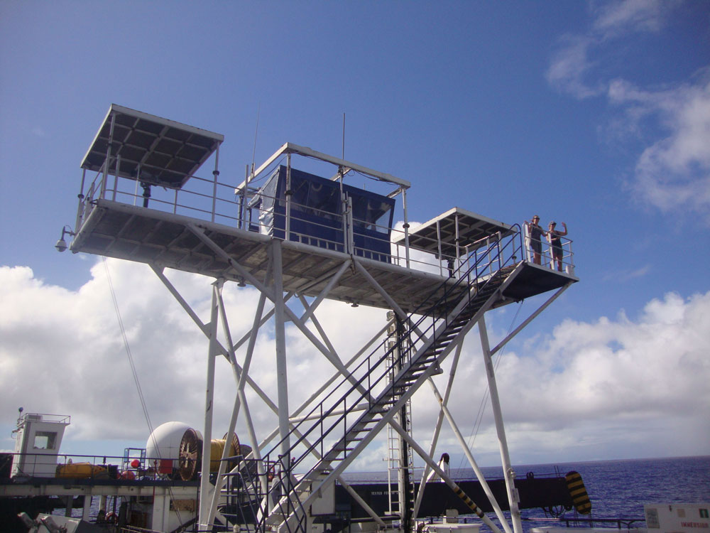
Figure 2. Protected Species Observers watching for marine wildlife.

Figure 2. Protected Species Observers watching for marine wildlife.

Day two, I walk down to my post in the lab only to find that nobody is there. Odd, I say to myself. I see on one of the remote cameras that everyone is outside working on the deck. I make my way aft and I’m instructed to put on a life jacket and “get to work.” The task at hand is to get the seismic streamer into the water. At this point, the streamer’s technicians, watchstanders, and ship’s crew were all working together. We were in charge of the streamer length number, the spacing of weights that need to be on the streamer, the spacing of acoustics, and position of birds. On this cruise (MGL1204) the streamer length was 8000 m. Along with the OBSs (ocean bottom seismometers), the streamer was used to record data in the active source survey. Hydrophones were strategically placed along the entire streamer. Because of the precise spacing of all the elements of the streamer, and the long length, it took about 12 hours to put it all in the water. It was great to be able to work with the ship’s crew and aid in the technical aspect of the mission. As a watchstander, they pretty much let you participate as much as you want to. I was carrying birds, putting them on the streamer, coupling streamer lengths, and adding weights, all while the sun was rising. It was fun, and exciting to be part of such a technical aspect of the project. Once the streamer was fully out, the gunners began the process of putting out the guns. Once the guns were in place, they began firing and we started collecting our active source data. After each “shot” from the air guns, the acoustic echo from the ocean floor was picked up by the hydrophones on the streamer and the OBS’s on the ocean floor. The data was then used to create bathymetric profiles of the sea floor around the trench.

Once the streamer and guns were in place, it was smooth sailing in terms of the instruments; the seas, on the other hand, were the contrary. The wind increased to 30 knots and the seas grew to 4-6 meters. Large seas, as you can imagine, change life aboard a ship. Everything is in constant motion. Sleeping was another story. Imagine sleeping in a moving bed…not conducive to quality rest. The way I solved that problem was by stuffing a bunch of blankets under one side of my mattress. This in effect created a v-notch that basically held me in one spot.

Life on a ship during a research mission is a lot of work. But nobody can work 24 hours a day. There was plenty to do on the ship during down time. After a few days, everyone began to fall into their own routine. There was a full theater, complete with big screen TV, PlayStation 3, and a hard drive filled with movies and TV shows. This was a good place to go and unwind after a long shift, or if the boat was pitching too much to sleep. At any given time, there was bound to be someone there to share a laugh with.

For exercise, the ship had a nice gym. A month is a long time to go without working up a sweat, the gym was a good place to get the heart rate up. There was a treadmill, elliptical, erg, and bike. The gym was also home to some dumbbells and homemade equipment, rendered by the engineers and ship’s crew over the years. A descent swell made working out quite interesting. With any pitch or roll of the ship, you could be sent flying. After a couple minutes of practice, though, you could get the hang of it.

Figure 3 (left). The main lab.  Figure 4 (middle). A line‐up of birds for the streamer. Watchstanders Matt Hughes and Martina Coccia assisting the ship’s crew. Figure 5 (right). Guns discharging.

Figure 3 (left). The main lab. Figure 4 (middle). A line‐up of birds for the streamer. Watchstanders Matt Hughes and Martina Coccia assisting the ship’s crew. Figure 5 (right). Guns discharging.

As for meals, the ship is equipped with a full galley and mess hall. Meals were served three times a day, but there was always food available. Dinnertime was especially good to relax and chat with other people on the ship. Sometimes, if it was nice, we would take our food up to the deck and eat outside under the Pacific sky. Sunset and sunrise were two of my favorite times on the ship. Its funny how on a ship, watching the sun go down or come up becomes another part of the routine. It was like a morning and afternoon break from the fast-paced research.

One of my favorite sky-watching spots was on the PSO bridge. Every seismic ship now has a crew of PSO’s or Protected Species Observers. These people spend their day watching the water. Their job is to make sure the seismic survey does not disturb or injure any marine life. They are on the lookout for whales, dolphins, seals, and other large marine mammals. If they see one too close to the ship, we stop firing the guns until the marine life has been deemed out of the danger zone.

In the end, I was happy to be part of such an interesting experiment. I arrived with no idea what to expect. By the end of the cruise, I was comfortable with technical equipment and data analysis in the lab. I got to meet several geophysicists and the whole ship’s crew. If you have any interest in how active source reflection seismology is carried out, get on a research cruise. You will learn about geophysics as well as about yourself. Thanks to the R/V Marcus Langseth MGL 1204 crew!

“Report from the Field” was designed to inform the community of real-time, exciting GeoPRISMS -related research. Through this report, the authors expose the excitement, trials, and opportunities to conduct fieldwork, as well as the challenges they may have experienced by deploying research activities in unique geological settings. If you would like to contribute to this series and share your experience on the field, please contact the GeoPRISMS Office at info@geoprisms.nineplanetsllc.com. This opportunity is open to anyone engaged in GeoPRISMS research, from senior researchers to undergraduate students.
We hope to hear from you!
Reference information
R/V Marcus Langseth Cruise to the Mariana Trench: February 2-29, 2012 Large Scale Active/Passive Source Seismic Experiment Lundquist J., Wiens D.;

GeoPRISMS Newsletter, Issue No. 29, Fall 2012. Retrieved from http://geoprisms.nineplanetsllc.com

Leveraging IODP Scientific Drilling in Support of Subduction Cycles & Deformation Science Objectives: AGU Mini-Workshop 2012


AGU Fall Meeting 2012, San Francisco, USA

Workshop Conveners: Robert Stern1, John Jaeger2, Brian Jicha3, Terry Plank4, Dave Scholl5, Gene Yogodzinski6

1University of  Texas, Dallas; 2University of Florida; 3University of Wisconsin; 4Lamont-Doherty Earth Observatory; 5U.S. Geological Survey; 6University of South Carolina

About 25 scientists attending Fall AGU meeting in San Francisco took a couple hours out of their busy schedules to participate in a Thursday evening mini-workshop at the Grand Hyatt about how to best use seafloor drilling to address GeoPRISMS Subduction Cycles and Deformation (SCD) science objectives. A new decade of scientific ocean drilling will occur when the new International Ocean Discovery Project (IODP) gets underway; this is planned for 2013-2023 (For more information about IODP and GeoPRISMS, look at the GeoPRISMS Fall 2012 Newsletter). The primary goal of the AGU mini-workshop was to stimulate interested geoscientists to consider how IODP drilling in the Aleutians, Cascadia, and Hikurangi margins can attack the seven “key questions” in the SCD Initiative draft Science Plan. The two-hour brainstorming session was fueled by hors d’oeuvres, a cash bar, and six brief (5 minute presentations plus 10 minutes discussion) talks.

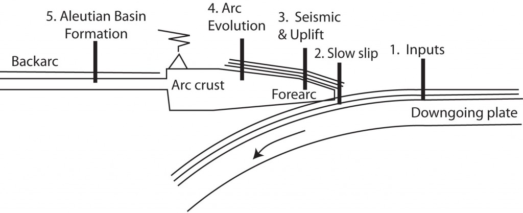
Figure 1. General diagram showing tectonic locations being discussed for IODP drill sites in support of GeoPRISMS science objectives. Site 1: sediment and basement inputs to subduction factory and seismogenic zone, important for Cascadia, Aleutians, and Hikurangi. Site 2: Shallow drilling to understand slow slip events, suggested for Hikurangi margin. Site 3: forearc drilling to reconstruct megathrust events and mountain growth, suggested for Aleutian and Cascadia margin. Site 4: Volcanic history (via tephra) and early arc basement, suggested for Aleutian arc. Site 5: Aleutian Basin formation and evolution.

Figure 1. General diagram showing tectonic locations being discussed for IODP drill sites in support of GeoPRISMS science objectives. Site 1: sediment and basement inputs to subduction factory and seismogenic zone, important for Cascadia, Aleutians, and Hikurangi. Site 2: Shallow drilling to understand slow slip events, suggested for Hikurangi margin. Site 3: forearc drilling to reconstruct megathrust events and mountain growth, suggested for Aleutian and Cascadia margin. Site 4: Volcanic history (via tephra) and early arc basement, suggested for Aleutian arc. Site 5: Aleutian Basin formation and evolution.

Terry Plank discussed how to use the drillship to determine subduction zone inputs. It is essential to sample the oceanic crust and sediments that are subducted at each margin, in order to understand how these inputs affect the mechanical properties of fault zone rocks, the generation of fluids in the subduction zone, and the formation of arc magmas (Fig. 1 site 1). Terry noted that for Cascadia there are already several sediment reference sites, and there are even sites in the northern Juan de Fuca plate where basement has been well-sampled and studied hydrologically. These materials need to be analyzed in order to establish the chemical composition of what is being fed into the Cascadia subduction zone. A major uncertainty is what is accreted in the fore-arc and what is swept down to ~100 km to feed the arc magmatic system. Understanding inputs to the Aleutian-Alaskan subduction factory is a bigger problem: this convergent margin is much longer than Cascadia (~3000 km vs. ~1000 km) and sedimentation on the downgoing plate changes along strike from thick, abyssal plain and trench-axis turbidite deposits in the east to thin pelagic sediments overlain by thinning trench-axis deposits in the west. For the eastern Aleutians, we have good but very incomplete DSDP sampling of the Zodiac Fan and more sediment coring in the Gulf of Alaska is expected from scheduled drilling. In contrast, not much is known about sediments on the downgoing plate feeding the intra-oceanic Aleutian arc, west of the Bering shelf break. Fracture zones (FZ) like the Amlia FZ provide additional complexity: these may mark unusual zones of thick sediments, altered oceanic crust, and serpentinized mantle. Can we recognize these inputs in the resultant arc magmas? The subducted oceanic crust appears to become ever more important to arc outputs toward the west, but less than 20 meter of basaltic basement have been recovered from the entire 3000 km Aleutian sector. We need to recover several hundred meters of oceanic crust, because we cannot constrain how much H2O and CO2 is carried down into the subduction zone unless we understand alteration of the subducting oceanic crust. For the Hikurangi margin, ODP Leg 181 sampled the upper sediments, but the lower km (related to Hikurangi Plateau volcanism) has not yet been sampled. Plans are underway, however, to drill a new section of sediment and basement input to the Hikurangi margin (see below).

Dave Scholl outlined how we could obtain a long-term history of major Aleutian seismogenic zone earthquakes by drilling into the forearc to core the deposits of landslides and turbidites that shallow earthquakes create (Fig. 1 site 3). There are two challenges here: to distinguish seismogenic deposits from those produced by other causes, such as non-seismic forearc slope collapse; and how to date these deposits – once identified – with the precision needed at the scale of the seismic cycle? It was also noted that we have a better understanding of the Cascadia seismogenic record than we know the Alaskan record, in spite of the fact that major (M>8 to 9.2) earthquakes (eight have occurred since 1899) are more frequent along the Alaskan-Aleutian margin.

John Jaeger continued on the theme of how we could interpret tectonic history from studying deep sediment cores (Figure 1, site 3). He outlined how these sedimentary records could illuminate linkages between uplift and deformation on the one hand and climate-mediated erosion of growing mountains on the other hand. He further noted how these could combine to create a high sedimentary flux that can turn off forearc deformation.
Brian Jicha explored how the drillship could be used to understand the early Aleutian subduction zone development, and how the arc magmatic system has since evolved (Figure 1, site 4). Aleutian arc subduction is thought to have begun in Eocene time – perhaps along an E-W trending fracture zone – capturing part of the Mesozoic Kula or Resurrection plates to form the Aleutian Basin (see below). We should be able to find a suitable place in the Aleutian forearc where a continuous tephra record – the products of Aleutian and Alaskan explosive eruptions – is preserved. The tephra record – which has wind-direction and compositional bias – could be supplemented by volcaniclastic sediments, which is less compositionally biased but which would preserve the magmatic record of a few upslope volcanoes. Drilling through sedimentary cover to sample forearc basement should recover magmatic products accompanying formation of the Aleutian subduction zone. It is possible that the Aleutian Basin formed by Paleogene backarc spreading, instead of being trapped Pacific/Kula/Resurrection plate. Recovery and study of Aleutian Basin crust would be a primary constraint on timing and nature of Aleutian arc subduction initiation.

Bob Stern outlined using the drillship to understand the age and origin of the Aleutian Basin, and use this information to constrain interpretations of surrounding regions (Fig. 1 site 5), such as the early history of the Aleutian Arc as well as the thermal history of the Aleutian Basin and basement-rock beveled Beringian Shelf. The issue is that there is a lot of sediment in the Aleutian Basin (km’s), but there might be regions where the sedimentary section is thinner. By drilling to basement though 1.5 km of sediments, we should recover a complete high-latitude record of Cenozoic climate history as well as direct age of Aleutian Basin crust.
After these five samplers, we heard briefly about more advanced plans for drilling in the Hikurangi SCD focus site to understand slow slip events (Figure 1, site 2) from Laura Wallace. Hikurangi slow slip events are unusually shallow and may propagate all the way to regions near the trench that are accessible to drilling. Drilling may thus give us direct access to sampling rocks and fluids formed in association with slow-slip events. A riserless drilling proposal currently in the review and ranking process has a coring transect from the subducting plate (inputs) across the overriding plate above the SSE source. There is an input site planned: 1 km of sediments followed by ~200 m penetration into basement. The input site will provide protoliths of the fault zone rock at depth in the slow slip event source area. A proposal to drill a ~5 km riser hole will be submitted in April 2013. Hikurangi drilling will collect samples related to the former MARGINS “Source to Sink” site in the nearby Waipaoa catchment.

We were also told about an interesting Brothers volcano (Kermadec Arc) IODP pre-proposal in the works, and a full IODP proposal to drill at the Lord Howe Rise and New Caledonia Basin to look at the consequences of subduction initiation along the Tonga/Kermadec/Hikurangi subduction system. These two proposals are likely to be submitted in April 2013.

Figure 2: Participants of the GeoPRISMS/IODP mini-workshop take a break between sessions.

Figure 2: Participants of the GeoPRISMS/IODP mini-workshop take a break between sessions.

Following these presentations, the floor was open to other inputs. Gene Yogodzinski led the group in broad discussions, from Cascadia sediment input, the need for coring into oceanic basement at all sites, the importance of water-rich saponite in oceanic crust, the importance of studying input material to understanding the rheology of the plate interfaces, to the opportunity presented by drilling into the Amlia fracture zone because of unusual sediments and ocean crust alteration, to the importance of biogenic silica as a fluid source, to further discussion of the significance of the tephra record, to engineering considerations for drilling in the Aleutian Trench, to the Cascadia fore-arc slope basins being obvious targets for sampling the paleoseismic record.

After the open discussion, John Jaeger outlined how to propose an IODP workshop, which is useful for moving from broad ideas to specific drilling proposals. Since the workshop, we have learned that guidelines for preliminary proposals are being revised and will be in place for the Oct. 1, 2013 deadline. Some groups interested in similar drilling objectives gathered to begin planning.

Reference information
Leveraging IODP Scientific Drilling in Support of Subduction Cycles & Deformation Science Objectives: AGU Mini-Workshop 2012, Stern, R., Jaeger, J., Jicha, B., Plank, T., Scholl, D., Yogodzinski, G.

GeoPRISMS Newsletter, Issue No. 30, Spring 2013. Retrieved from http://geoprisms.nineplanetsllc.com

Workshop Report: “Ultra-Deep Drilling Into Arc Crust: Genesis of Continental Crust in Volcanic Arcs”


Waikoloa, Hawaii, 18-21 September, 2012

Workshop Conveners: Yoshihiko Tamura1, Shuichi Kodaira1, Susan M. DeBari2, Jim Gill3

1JAMSTEC, Japan; 2Western Washington University, USA; 3University of California, Santa Cruz, USA

Compiled by Susan DeBari, Philipp Ruprecht and Susanne Straub

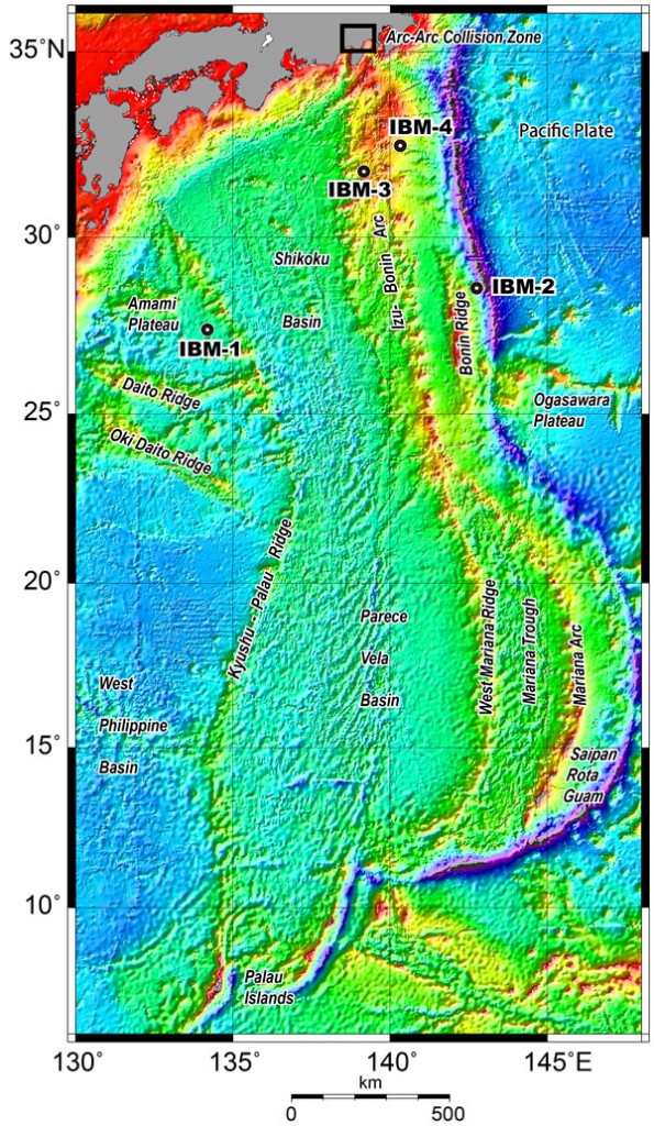
Figure 1. Location map of the Philippine Sea Region. Numbers show proposed drilling sites IBM-1, IBM-2, IBM-3, and IBM-4.

Figure 1. Location map of the Philippine Sea Region. Numbers show proposed drilling sites IBM-1, IBM-2, IBM-3, and IBM-4.

A workshop was held September 18-21, 2012, in Kona, Hawaii, with the goal of soliciting international support for the endeavor of understanding continental crust formation in the Izu Bonin arc in the northwest Pacific ocean. Central to this project is riser-based deep drilling into the mid-crust of the Izu Bonin arc using D/V CHIKYU. The workshop was primarily sponsored by a Grant-in-Aid for Creative Scientific Research 19GS0211 to Y. Tatsumi and JAMSTEC. Additional funds to support attendance of U.S.-based scientists were obtained from the U.S. Scientific Support Program (through the Consortium for Ocean Leadership) and the GeoPRISMS Program.

The ~3000 km long intra-oceanic Izu Bonin-Mariana arc (IBM) has been long recognized as a primary site for understanding the formation of the continental crust (Fig. 1). A long history of past multidisciplinary exploration revealed the ubiquitous presence of a conspicuous low-Vp velocity (6.0-6.5 km/s) mid-crust layer that seismically resembles continental crust. This layer is common in arc crust, and, as such, is crucial in interpreting arc crustal structure globally. In the northern part of the IBM system (the Izu Bonin arc), the low-velocity mid-crust layer is within reach of ultra-deep riser-drilling and has been a dedicated target of the International Ocean Discovery Program (IODP). The IODP Science Plan for 2013-2023 “Illuminating Earth’s Past, Present, and Future” highlights the formation of continental crust as high-priority scientific Challenge 11 “How do subduction zones initiate, cycle volatiles, and generate continental crust?” as part of the main theme “Earth Connections: Deep Processes and Their Impact on Earth’s Surface Environment”.

Deep-drilling a single hole into the Izu Bonin arc is a major commitment in time and resources. Success is reliant on three companion riserless drilling expeditions in the arc by D/V JOIDES Resolution that are scheduled for 2014. These expeditions will provide crucial new data for the overarching goal of obtaining a complete temporal and spatial petrologic cross-section of Izu Bonin arc magmatism. These expeditions provide vital support for the planned CHIKYU drilling (IODP Proposal 698-Full3 at Site IBM-4) that will be discussed as a priority project at the CHIKYU+10 workshop on 21-23 April 2013 in Tokyo, Japan. This workshop will prioritize the future activities of the CHIKYU.

Overview

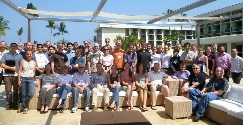
The workshop was attended by 58 participants (34 from US, 13 from Japan, 4 from UK, 2 from Switzerland, and 1 each from Mexico, Canada, Taiwan, New Zealand, Australia, Figure 2).

Figure 2. All participants at the conference venue, Waikoloa Beach Marriott, on the Big Island of Hawaii.

Figure 2. All participants at the conference venue, Waikoloa Beach Marriott, on the Big Island of Hawaii.

Attendees included a wide range of geophysicists, geologists, geochemists and petrologists whose research involves the genesis of arc crust. A primary goal of the workshop was to inform the broader geologic community about the goals of drilling in the Izu Bonin arc, as well as to solicit a very broad, international base of participation in proposed IODP expeditions, to rally support for the planned CHIKYU deep-drilling, and to obtain input on objectives and corollary studies.

The first day opened with background talks and discussions aimed at providing a framework for the proposed drilling. Talks focused on the physical and geochemical evolution of the Izu Bonin Mariana arc through time, the geophysical framework (including the enigmatic seismic properties of the middle crust and comparison to the Aleutian arc), and an overview of the goals of the three scheduled IODP drilling legs (subduction initiation, arc foundations, rifted rear arc).

The second day focused specifically on the CHIKYU deep drilling proposal and potential outcomes. This theme was supported by talks on the processes of crustal growth and evolution from exposed crustal sections and from thermal modeling.

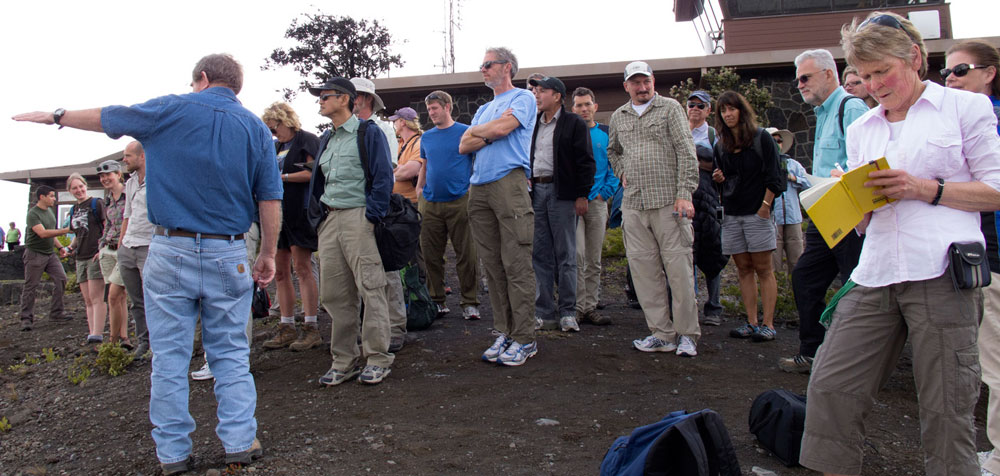
The third day provided a break from talks in the conference room and allowed more informal discussions among participants during a field trip to observe the geology of the active Kilauea Volcano eruption (Figure 3).

Figure 3. Participants looking over at the summit caldera of Kilauea and the active eruption in Halema’uma’u crater during the field trip led by Don Swanson.

Figure 3. Participants looking over at the summit caldera of Kilauea and the active eruption in Halema’uma’u crater during the field trip led by Don Swanson.

The forth and final day focused on specific scientific objectives for deep drilling in the Izu Bonin arc and what at-sea drilling strategies and shore-based studies would best support those objectives.

Workshop Program

The key question that motivates deep drilling in the Izu Bonin Mariana arc is how the middle crust evolves and how the processes of its growth relate to the growth of continental crust. Deep drilling in the IBM arc offers the opportunity to examine the critical relationships between magmatic processes and resulting geophysical structure. The linkages established here can also be used as a template to interpret active arc processes globally from geophysical surveys.

The workshop was structured around several key topics, and the key results are as follows:

(1) Geophysical overview of the Izu-Bonin-Mariana arc-back-arc system

More seismic surveys have been acquired over the IBM arc-back-arc system than any other island arc setting on Earth. Consequently, it is possible to contrast seismic velocity models across the arc representing different evolutionary histories, and to constrain them with strike lines where available. A multi-channel seismic reflection (MCS) survey was acquired in 2008 around the proposed drilling site of IBM-4 revealing a well-resolved domal basement high beneath the proposed drilling site. Comparison of MCS data with core recovered from ODP Site 792 indicates the section above the basement is comprised of Quaternary to upper Eocene volcaniclastic sediments. At the top of the basement high, andesitic lavas were sampled at 886 meters below seafloor (mbsf). A seismic refraction survey using densely deployed ocean bottom seismographs (OBSs) was also conducted along the MCS profile and clearly show a domal structure in the 6 km/s Vp iso-velocity contour. These Vp values, which are critical to identification of the middle crust, are located 3.5 km below sea floor at Site IBM-4, within reach of CHIKYU drilling.

(2) The generation of intermediate composition (andesitic) magmas and their relevance to growth of continental crust

The workshop presentations and discussions reinforced consensus that the Izu Bonin arc was the ideal place worldwide to study juvenile mid-crust formation, as there is minimal sediment recycling and minimal pre-existing continental crust. Hence, the net flux from the mantle/subduction zone to the crust is visible with the greatest possible clarity.

Specifically questions to address include the following:
  • What is the origin of the mid crust (test various hypotheses)
  • Are intrusive and extrusive rocks genetically related (i.e., does the mid crust form in a distinct manner from the extrusive rocks)?
  • Do all arc magmas stall at mid-crust levels before eruption?
  • How fast do magmas ascend from mantle to crust?
  • How are mafic magmas expressed within the crust – are they long-lived evolving bodies or rapidly solidifying small plutons?
(3) Using exposed arc sections in conjunction with IBM deep crustal drilling to understand the generation and growth of arc crust, and transferability to other active arc settings

Investigation of arc crustal sections exposed on land provide an important companion study for deep crustal drilling. The study of paleo-arcs provides a larger, more volumetrically abundant record of both the intrusive and extrusive record of the processes that generate continental crust from mantle-derived magmas. In turn, deep crustal drilling can answer many questions that remain unanswered after examination of exposed sections, the activity of which ended long before they were amassed in their current locations. For example, through the direct petrological, geochemical, and geophysical characterization of the crust at site IBM-4, a reference section of intraoceanic arc crust can be generated. The cored rocks and borehole properties can be directly linked to the seismic velocity structure of the crust, providing the first in situ test of seismic velocity models against known rock types and structures within the deep arc crust. The IBM-4 site will provide an essential reference both for active arc crust and for accreted arc crustal terranes.

(4) Other salient points related to drilling operations

  • Temperature estimates for the proposed drilling depth of 5500 mbsf at IBM-4 do not exceed 170°C
  • All coring cannot reasonably be obtained throughout the 5500 m drilling depth so borehole imaging technology will be critical. Drilling operations will also include sidewall coring (sampling from uncored intervals) and vertical seismic profiles.
  • Costs for drilling with Chikyu will be on the order of $600,000 – $700,000 per day, with an estimate of roughly 9 months to reach 5500 mbsf. The total cost is thus as much as $200 million.
(5) Scientific objectives
At the end of the workshop, participants formalized ten of the most important scientific objectives of drilling at Site IBM4. These objectives are as follows:
  • What is the tempo of constructing arc juvenile continental crust?
  • How does arc crust composition change with time?
  • Is there older (pre-51 Ma) crust that makes up significant parts of the Izu arc?
  • How do the results of ultradeep drilling into the Izu forearc fit with perspectives gained from other drill sites and from arc crustal sections?
  • What is the relationship and proportion between volcanic and plutonic rocks in ultradeep juvenile arc crust?
  • What was the role of fluids in the evolution of the rocks that we will penetrate?
  • What is the nature of the ultradeep biosphere?
  • What can we learn about convergent margin mineralization by ultradeep drilling into arc crust?
  • What is the paleomagnetic record preserved in Izu arc crust?
  • How well can we use surface geophysical measurements such as heat flow and seismic velocity to infer properties at depth?

Given the distinct core recovery rate in riser-drilling platforms (i.e. targeted sampling) compared to riserless drilling (i.e. almost continuously coring possible) the workshop discussions also revolved extensively around how to prioritize sample recovery strategies. Workshop participants made recommendations for prioritizing sample recovery, in particular around transitional zones derived from geophysics as well as extensive coring at the base of the drillhole. Further discussion is likely to occur at Chikyu+10.

For a more detailed report on the workshop see http://www.jamstec.go.jp/ud2012/

Roadmap to Future scientific drilling in the Izu Bonin arc

In 2014 three-riserless expeditions with JOIDES Resolution are scheduled in three sites (IBM-1, IBM-2, IBM-3) of the Izu-Bonin Arc. A call to participate in these expeditions has been made with application deadlines of May 1, 2013. The three legs (each about two month duration starting in April 2014) are designed to address key questions of crust generation and modification. The expeditions will be kicked off at site IBM-3 in the rear Izu arc to generate data on the missing half of the subduction factory, as most drilling efforts have focused on the IBM forearc. This leg will document across-arc variation in magma composition from Eocene to Neogene time to test models of mantle flow, intra-crustal differentiation, and magma generation during the arc evolution. The following two months are scheduled to drill into a section of pre-arc oceanic basement at site IBM-1 (695-Full2). This site is located beneath the 1-1.5 km of sediments in the Amami Sankaku Basin west of the Kyushu-Palau Ridge remnant arc. Such basement may make up an important part of the lower-arc crust, and contribute to arc magma chemistry through assimilation and partial melting. The 2014 drilling campaign in the Izu-Bonin arc will finish at Site IMB-2, close to the Bonin Ridge (696-Full3). The goal at this site is to unravel subduction initiation and test the supra-subduction zone ophiolite model.

Although each of the three scheduled JOIDES Resolution expeditions stand on their own merits, they will also deliver crucial complementary data for the ambitious ultra-deep drilling proposal (IBM-4; 698-Full3). The ultra-deep drilling project itself would provide first-ever in-situ unaltered samples from the region in the arc crust where crustal differentiation and evolution is most dramatic. The “transferability” of a direct view of the nature of the middle crust in the Izu-Bonin arc with crustal studies from exhumed sections has the potential of being mutually transformative. Ground-truthing potential exists for a large variety of techniques. How do seismic velocities and densities vary locally in the borehole and how are those parameters recovered from surface observations? How accurate are surface heat flow measurements in projecting the thermal evolution in the borehole? In addition, deep drilling provides tremendous opportunities to obtain new insights on fluid compositions and distribution in the crust, the presence of a deep biosphere, and the potential for observing in-situ mineralization processes.

The new data from all these drilling expeditions will provide for innovative cross-disciplinary research through the integration of many subdisciplines and multinational specialists. The extraordinary collaborative effort made at sea will culminate in extensive post-cruise shore-based studies (e.g., isotope geochemistry, thermo- and geochronology, geophysical experiments with core samples) that are set to transform our understanding how juvenile arc crust forms and differentiates with time.

Reference information
Workshop Report: “Ultra-Deep Drilling Into Arc Crust: Genesis of Continental Crust in Volcanic Arcs”, DeBari S., Ruprecht P, Straub S.

GeoPRISMS Newsletter, Issue No. 30, Spring 2013. Retrieved from http://geoprisms.nineplanetsllc.com

Report: ExTerra 2013 – Understanding Subduction through the Study of Exhumed Terranes


August 24-25, Florence, Italy

M. Feineman1 & S. Penniston-Dorland2

1Pennsylvania State University;  2University of Maryland

Figure 1. ExTerra 2013 workshop participants.

Figure 1. ExTerra 2013 workshop participants.

On August 24-25, 2013, geoscientists met in Florence, Italy for the ExTerra 2013 workshop prior to the Goldschmidt conference. In all, there were 33 participants from 9 countries, including 11 students, 2 post-docs, and 5 early-career faculty. Workshop participants divided into three groups based on different types of exhumed terranes: subducted slab, mantle wedge, and arc crust. The groups were tasked with refining the key scientific questions previously identified in the ExTerra White Paper (2012) and discussing future directions for ExTerra.

What is ExTerra?

ExTerra is a group of individuals interested in studying exhumed rocks of ancient subduction zones in order to understand the processes that operate deep within subduction zones. Our ongoing mission is to explore how we can best organize research on exhumed terranes such that we might accomplish more as a group than we can as individuals working independently. Three target areas have been identified as significant to improving our understanding active subduction processes by the study of exhumed terranes:

  1. Subducted slab, including HP and UHP rocks such as blueschists, eclogites, and metapelites;
  2. Mantle wedge, including serpentinites, ophiolites, and peridotites; and
  3. Middle and lower arc crust, including granitoids, gabbros, migmatites, gneisses, amphibolites, granulites.

Workshop summary

Figure 2. ExTerra 2013 workshop participants learn about US examples of exhumed arc crust sections from Mihai Ducea.

Figure 2. ExTerra 2013 workshop participants learn about US examples of exhumed arc crust sections from Mihai Ducea.

Day 1: Science Questions

The first day consisted of a full day of scientific presentations with ten keynote talks followed by an evening poster session. The talks were chosen to emphasize cutting-edge research on the processes and materials found deep within subduction zones and ultimately exhumed at the Earth’s surface, and to stimulate discussion of the Big Science Questions that can be addressed using rocks from exhumed terranes. The keynote speakers and topics are listed in the table below.

Day 2: Planning for the Future

The second day was focused on the future of ExTerra and included presentations on potential field institute localities and a discussion of sample and data management led by Kerstin Lehnert, Director of Integrated Earth Data Applications (IEDA). The workshop participants then separated into breakout groups by target area to refine the key scientific questions identified in the first ExTerra white paper (2012), and to discuss future directions for ExTerra, including potential field institute localities.

Table 1. List of speakers and presentations
Speaker Institution Talk Title
Subducted Slab
Ethan Baxter Boston University The growth of garnet and the chronology of slab dehydration
Philippe Agard UPMC (Paris VI) Into the subduction plate interface?
Horst Marschall WHOI The importance of hybrid rocks for transient trace-element and volatile storage at the slab-mantle interface
Mantle Wedge
Peter Kelemen LDEO – Columbia Field observations and thoughts about carbon transfer from metasediments into the mantle wedge in oceanic subduction zones
Jaime Barnes UT, Austin Geochemical signature of a serpentinized mantle wedge
Katherine Kelley URI – GSO Mantle wedge oxygen fugacity
Sarah Brownlee Wayne State University Seismic signatures of a hydrated mantle wedge from antigorite crystal preferred orientation (CPO)
Arc Crust
Mihai Ducea Univ. of Arizona A review of some of the most important exhumed crustal sections and xenolith localities from the Americas
Josef Dufek Georgia Tech Magmatic connections: The interplay of magmatic systems with their crustal containers
Olivier Jagoutz MIT The formation of continental crust: the seismological perspective

Big Science Questions

Workshop participants continued to explore and refine the Big Science Questions regarding subduction zones that can be addressed through the study of exhumed high- and ultrahigh-pressure rocks and terranes. A few of the many emergent and re-emergent themes include:

  • What are the timescales of fluid release and transport in the slab and mantle?
  • What is the physical nature of the slab-mantle boundary?
  • What is the relative importance of mechanical vs. chemical mixing across the slab interface?
  • How are volatiles (including CO2, H2O, and O2) stored and transported in the mantle?
  • What is the extent of mass exchange between arc magmas and arc crust?
  • Is the erupted component at volcanic arcs representative of the stored plutonic component in the middle-to-lower arc crust?
  • How different is the bulk composition of continental vs. oceanic arc crust?
  • How can we best relate observables from exhumed rocks to seismic observations and geodynamic models?

ExTerra Field Institutes

One proposed extension of ExTerra in the coming years is a series of field institutes that would gather groups of researchers (~20 participants) at a few world-class exhumed subduction localities with the purpose of exploring some of the key scientific questions identified in the ExTerra white papers. The field institutes would focus on targeted sample collection, supported by careful sample registration and data management. Institutes might also include field techniques such as LiDAR, handheld XRF, and in situ measurement of physical properties. After an initial time period (~18 months) during which samples would be preferentially accessible to field institute participants for analysis, all samples would be made publicly available for research purposes following a model similar to that employed by the Ocean Drilling Program. Proposed sites for future field institutes include Santa Catalina Island, CA; Santa Lucia Mountains, CA; Fiordlands, New Zealand; Sierra Valle Fertil, Argentina; and Monviso, Italian Alps.

Get Involved!
If you are interested in contributing to the discussion or joining the ExTerra mailing list, please contact us at: mdf12 (at) psu.edu or sarahpd (at) umd.edu For more information, visit the ExTerra webpage
Reference information
ExTerra 2013: Understanding Subduction through the Study of Exhumed Terranes, Feineman M., Penniston-Dorland S.
GeoPRISMS Newsletter, Issue No. 32, Fall 2013. Retrieved from http://geoprisms.nineplanetsllc.com