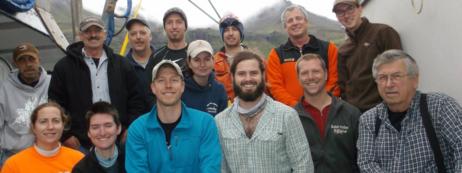
Putting the “Community” in the Alaska Amphibious Community Seismic Experiment (AACSE): Alaska Peninsula and Western Gulf of Alaska, Summer 2018


The AACSE Team*

*This report was edited and compiled by Lindsay Worthington.

AACSE PI team: Geoff Abers (Lead PI, Cornell U.), Aubreya Adams (Colgate U.), Peter Haeussler (USGS), Emily Roland (U. of Washington), Susan Schwartz (U. of California Santa Cruz), Anne Sheehan (U. of Colorado), Donna Shillington (Lamont Doherty Earth Observatory), Spahr Webb (Lamont Doherty Earth Observatory), Doug Wiens (Washington U. St. Louis), Lindsay Worthington (U. of New Mexico).

2018 Apply-to-Sail Participants: Collin Brandl (Graduate Student, U. of New Mexico), Enrique Chon (Graduate Student, U. of Colorado), David Heath (Graduate Student, Colorado State U.), Robert Martin-Short (Graduate Student, U. of California Berkeley), Kelly Olsen (Graduate Student, U. of Texas), Holly Rotman (Postdoctoral Researcher, New Mexico Tech), Samantha Hansen (Associate Professor, U. of Alabama), Tiegan Hobbs (Graduate Student, Georgia Tech), Amanda Price (Graduate Student, Washington U. St. Louis), Heather Shaddox (Graduate Student, U. of California Santa Cruz), Jefferson Yarce (Graduate Student, U. of Colorado Boulder), Natalia Ruppert (Seismologist, U. of Alaska Fairbanks)

K-12 Educators On Board: Shannon Hendricks (High School Science Teacher, Anchorage School District), Bethany Essary (High School Science Teacher, Anchorage School District).

The shore-based field teams included graduate student Michael Mann (Lamont-Doherty Earth Observatory) and undergraduate student Jordan Tockstein (Colgate U.). We thank the captain and crew of the R/V Sikuliaq and the pilots, boat captains and land owners that made these deployments possible. Special thanks to Bill Danforth from the USGS for his bathymetric processing expertise aboard Leg 2 and Patrick Shore from Washington U. for coordinating onshore field logistics and preparing the data for delivery to the DMC.

If you visit Alaska and tell people that you are a seismologist, you are going to hear an earthquake story. The Alaska-Aleutian subduction system is arguably the most seismically active globally, producing more >M8 earthquakes over the last century than any other. As a result, earthquake and tsunami hazard are woven into daily life here. Near downtown Anchorage, you can visit Earthquake Park, occupying part of town that was decimated by a landslide during the 1964 M9.2 event that inspired the term “megathrust” earthquake. If you happen to be in Kodiak on a Wednesday afternoon, you will hear the weekly tsunami siren drill sound throughout the town. Earlier this year that drill was put in to practice as residents made their way through the tsunami evacuation process, meeting up at the school on high ground after midnight on January 29 following the M7.9 earthquake that occurred offshore.
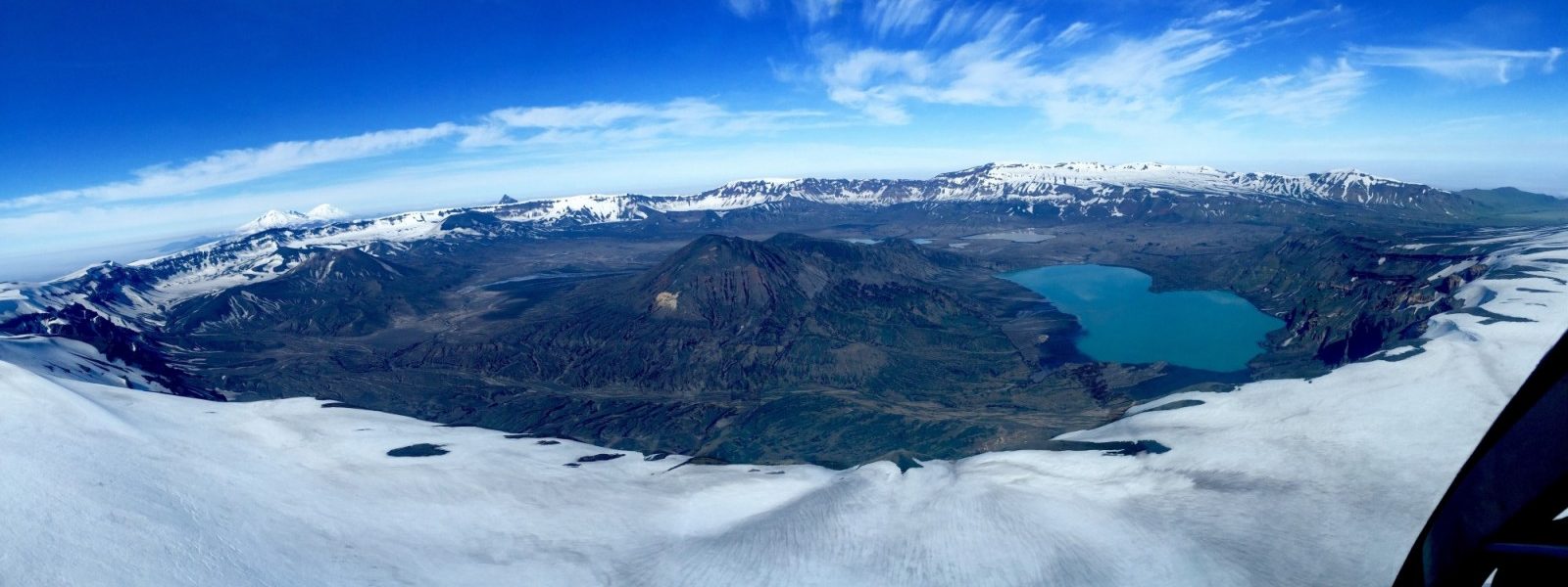
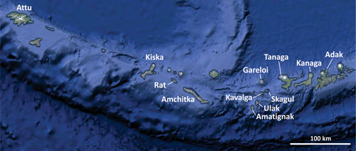
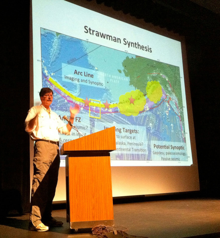
So, how do you study an 800 km section of this subduction zone that is mostly offshore or only accessible via air or boat? Simple. Start with nine Principal Investigators (PIs) and dozens of conference calls; take 85 ocean bottom seismometers (OBS), thirty broadband seismometers, one fishing boat, two float planes, two fixed wing planes, a helicopter, and a 261-ft research ship; add a team of twelve OBS engineers, 24 ships crew, twelve Apply-to-Sail participants, two Alaskan K-12 teachers and two field technicians. Then make the data open and accessible as quickly as possible. This is the Alaska Amphibious Community Seismic Experiment (AACSE) and these are voices from the field.

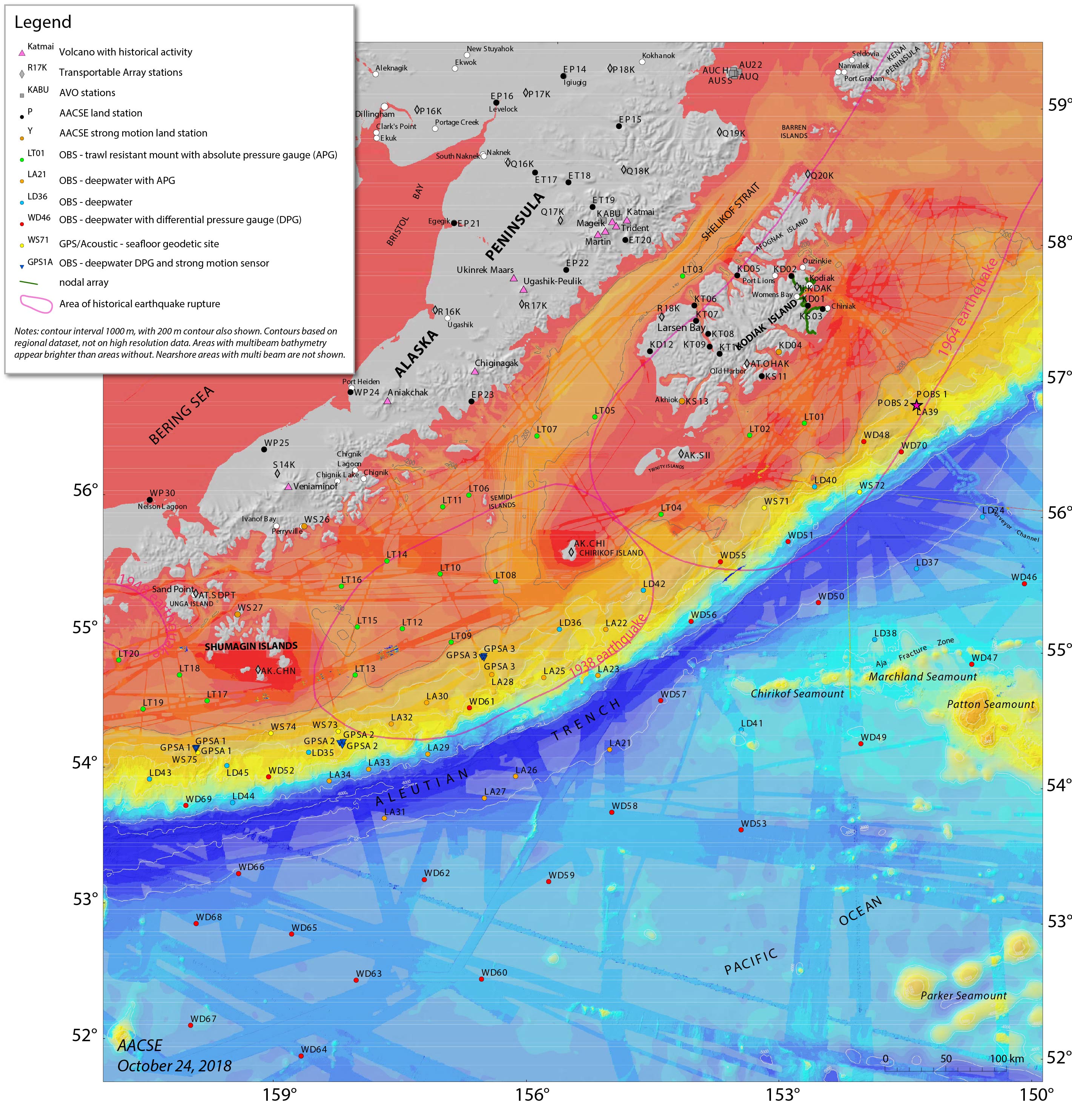
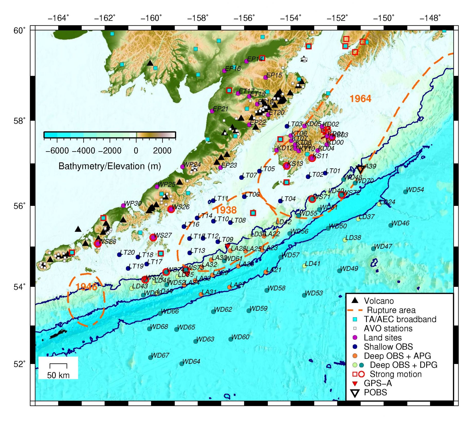
The Alaska Amphibious Community Seismic Experiment (AACSE) deployment map prepared by Peter Haeussle

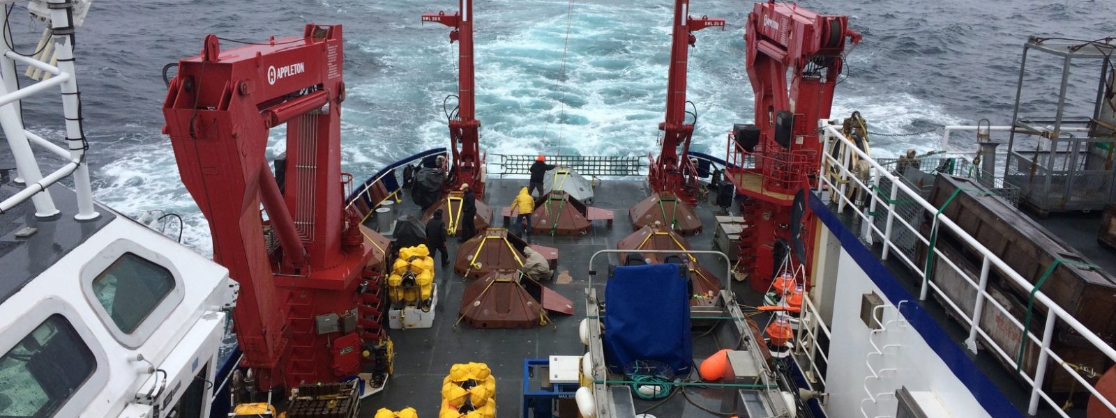
OBS Deployment Cruise Leg 1 | Seward, AK to Seward, AK – May 9-29, 2018

>> 9 May, 2018 | We are officially underway • It is 8:30am and we are departing Seward dock. We have donned our full-body immersion suits as part of a safety drill, and are now heading towards the first seismometer deployment site, lying in the Shelikof Strait just north of Kodiak Island. We are on one of the most modern and well-equipped scientific research ships in the world. The R/V Sikuliaq was built in 2014 and has a science lab, lounge, dining room, kitchen, gym, and the list goes on. There is even a sauna which apparently can double as a hypothermia recovery room – let’s hope we won’t be using it for that purpose. For cabins, we are treated to the height of oceanographic luxury. The rooms are practical and very comfortable. The Sikuliaq takes its name from the Inupiaq word that means “young sea ice”. Thanks to its round hull, the ship is capable of breaking ice up to 2.5 ft thick, which is essential on polar missions. This also gives it a tendency to move around more in high seas. As we travel, we will be collecting meteorological data such as pressure, temperature, and wind speed. We will also be recording bathymetry data to map the seafloor.

-Robert Martin-Short, University of California Berkeley

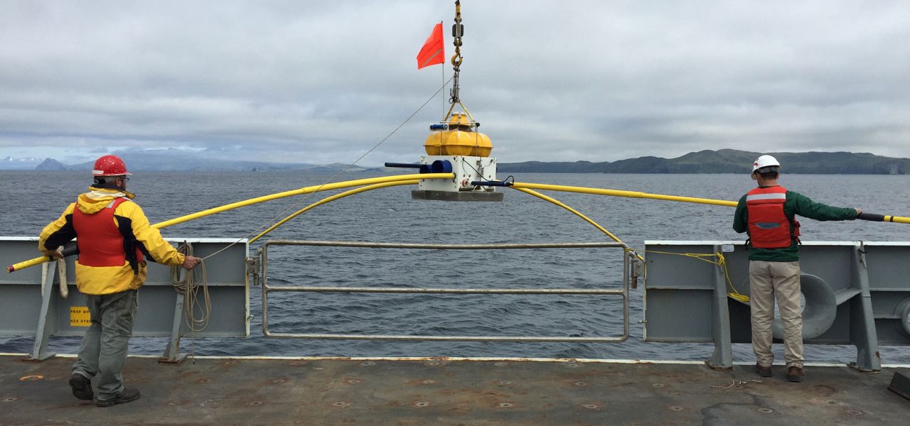
>> 10 May, 2018 | Deploying the first OBS instrument • The first OBS (Ocean Bottom Seismometer) is a shallow-water Trawl-Resistant Mounted Seismometer (TRMS), design to resist and deflect the lower leading line of bottom trawl nets. All of the OBSs are instrumented with a seismometer, batteries to last more than fifteen months, transponders to communicate with the ship and burn the wire to release the seismometer for recovery, data logger, temperature sensors, and other equipment necessary to collect these data. The shell for the TRMS itself weighs about 1,300 lbs, the whole instrument weighs about 1,800 lbs. The deployment is a success! After deploying the TRMS, we have to hide from foul weather in Larsen Bay, then assemble more TRMSs. This involves removing the doors and installing brackets to hold equipment, attaching hoods to the pop-up TRMS, checking the transponders to make sure they are properly communicating with the ship, and attaching the transponders. We will stay in the cove and work for a couple hours, then leave once the storm has passed.

-David Heath, Colorado State University

>> 12 May, 2018 | Waiting out the storm • Many of us are taking to personal hobbies and pastimes in between routine status logging. Some people are reading quietly. Others are attempting to catch up on emails, though the internet is particularly slow. Others are taking the opportunity to chat with shipmates, many of whom are still practically strangers after few days on the ship. I am learning that life on a ship provides a unique opportunity for people to connect with each other. I have spent part of the evening receiving a generous guitar lesson from the Chief Steward who is a skilled blues musician. He kindly reached out to play alongside me when he noticed me strumming out on deck. I’ve got to say, my experience thus far has been pretty great, despite the spotty weather and fits of acute nausea.

-Enrique Chon, University of Colorado

OBS Deployment Cruise Leg 2 | Seward, AK to Seward, AK; July 11-24, 2018

>> 11 July, 2018 | Educators Onboard • There are so many people involved in a research cruise like this. There is an entire ship crew, scientists, graduate students, USGS employees, OBS technicians, and, on this trip, there are even two high school science teachers and I am one of those. I am stoked to be on board. My colleague, Shannon Hendricks, and I were selected as part of the Educator Onboard K12 program. Through this program, educators are given the opportunity to participate in research to better understand current science practices. The goal is to use that knowledge to create engaging, authentic lesson plans to share with other educators. It is a little intimidating to meet all of these experts – as science teachers, we know a little bit about a lot of things, and we have a solid enough science foundation to understand what the experts are talking about (most of the time!). This also means we know enough to realize how much we don’t know! It is amazing to get to learn from scientists that have made this their life work. Getting to peek in on their ongoing research makes us better science teachers. And it is nice to know that, just like we tell our own students, there are no stupid questions.

-Bethany Essary, West High School science teacher, Anchorage, AK

>> 23 July, 2018 | The aftershock zone • Day 12 of the cruise, we have just successfully deployed our last OBS, 32 hours ahead of schedule! Half way through this cruise, we decided to move one of the instruments to near the aftershock zone of the M7.9 Offshore Kodiak earthquake. It struck about three hundred kilometers offshore Kodiak Island in the early morning hours of January 23, 2018, in the outer rise region of the Alaska-Aleutian subduction zone. It triggered tsunami warnings and prompted evacuations of thousands of people in Alaskan coastal communities. While the source parameters (such as seismic moment tensor) for the earthquake suggested strike-slip faulting (hence no significant tsunami generated), the true complexity of the source has only become evident through analysis of multiple datasets. At least four conjugate strike-slip faults were involved in the earthquake rupture. However, the distant location of the aftershock source region to the land-based stations made the data analysis and interpretation difficult. On the Leg 1 cruise, a couple of stations were serendipitously placed near or in the aftershock zone. After consultations with the PI group we moved this station to the aftershock cluster. This enhanced network of OBS sensors in the aftershock zone will help characterize the aftershock sequence with much better accuracy.

-Natalia Ruppert, University of Alaska

>> 24 July, 2018 | Good luck • For the past three years, I have been looking at OBS data off the east coast of New Zealand’s North Island, and I always wondered about the logistics behind the dataset of earthquakes. It turns out that deploying ocean bottom seismometers is a huge task that includes multiple people. This experience exceeds all my expectations. I imagined a repetitive process, but every single station has its own challenges: the bathymetry indicates a rough or steep relief so we have to move somewhere close by with a more flat and soft bathymetry; we need to be sure that the temperature sensors are the ideal for specific depths; we fill the sheets with station information and log it in our physical and digital forms, etc. This experience makes me really value all the effort that the science crew did for the deployment and recovery of the data that I am currently working on. For the future seismologists who are going to work with the data, I want to say that we did our best to make sure the seismometers were meticulously deployed and I am sure the recovery crew will be equally careful to collect the year-long log of wiggles from the stations deployed by the first and second legs. Good luck!

-Jefferson Yarce, University of Colorado

Onshore Deployment: Alaska Peninsula, Kodiak Island and Shumagin Islands; May-June 2018

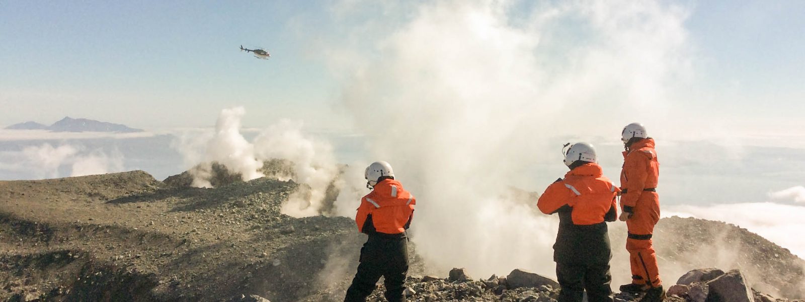
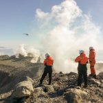
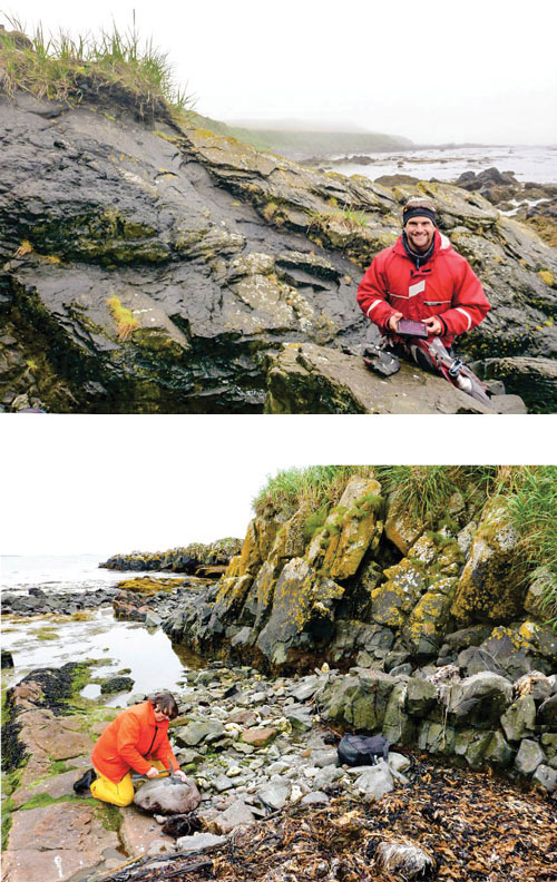
>> 16 May, 2018 | A for Amphibious • The second A in AACSE stands for Amphibious – fully encompassing the entire subduction zone requires making measurements on land and at sea. The onshore part of the program involves installing instruments on Kodiak Island, the Shumagin Islands (southwest of Kodiak), the Alaska Peninsula and the region around Katmai National Park. These thirty instruments will be placed in remote locations (black circles on the map p.19) accessed by float planes or small fixed-wing planes. One team of three people is installing thirteen sites on Kodiak Island, and a second team is deploying the rest of the sites on the mainland and Shumagin Island. Today the Kodiak team started their first day of work! Like working at sea, the initial work involves unpacking all the gear shipped from across the country, and testing and assembling everything. To make sure everything is working properly, we do a “huddle test,” where we set up all of the seismometers and data loggers in one place and let them collect data for one day. We are fortunate to have been given access to some space in the Kodiak Alaska Fisheries Science Center, a research facility that provides valuable data to the fishing industry and that has a wonderful aquarium. This means we are sometimes sharing the space with sea life, like a large half-decomposed salmon shark! Tomorrow, if all goes well, we can start deploying!

– Geoff Abers, Cornell University

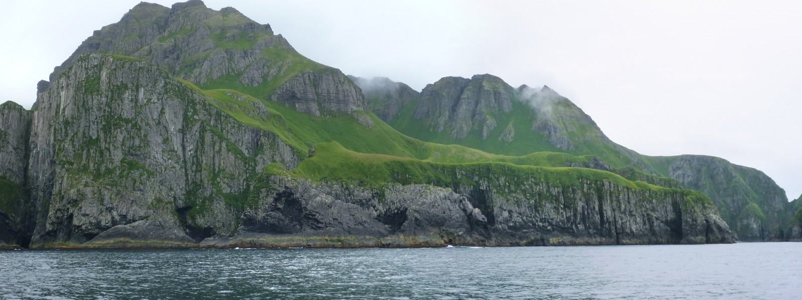
>> 21 May, 2018 | Kodiak Island • The road network on Kodiak Island is confined to the region around the town of Kodiak, so one must travel by boat or plane to reach other parts of this rugged and beautiful island. Eight of the thirteen seismic stations that we are installing here are both off the road system and far from towns with air strips, and we have been traveling to them by float plane. One limitation of using small planes for seismic installations is that there is a weight limit on what you can bring. The float plane we have been using, a de Havilland DHC-2 Beaver, can carry 1,200 lbs. Our field team and equipment for two stations weigh 1,175 lbs! We have to do a weigh-in before our first flight – fortunately they weighed our field team together and not individually. Flying also requires better weather than simply driving to a station. So far, we have found that the weather is worse on the eastern part of Kodiak near Kodiak town but improves to the west. We feel lucky to have had three days in a row where we could fly out to some of our sites. In the last three days, we have installed five stations that have taken us to many corners of Kodiak: McDonald lagoon on the southwestern coast, small Anvil Lake in far western Kodiak and the gorgeous Uyak Bay, a fjord that connects to the ocean in the north and cuts across two thirds of the island. This fjord is enabling us to deploy closely spaced stations over a part of the subduction zone fault where large earthquakes occur, one of the primary targets of this project. Traveling by plane across Kodiak is spectacular; you are treated to stunning views of snow-capped mountains and broad valleys. Sometimes you can see mountain goats lining steep slopes, bears meandering along the shore, and frolicking otters in the water. The views from our seismic sites are really amazing, too, when we look up from orienting sensors and plugging in data loggers. Six down, seven to go for the Kodiak team!

-Donna Shillington, Lamont-Doherty Earth Observatory

>> 30 May, 2018 | Challenging Conditions • The three members of the Sand Point team set sail on the Aleut Mistress to install two strong motion sites on Nagai Island. The day started with beautiful glassy-smooth seas and a calm two hour cruise to our first site on the north side of the island. We loaded our equipment into a skiff, hopped onboard and motored to our chosen landing site. This site was chosen by satellite imagery, and as always, conditions on the ground were a little different than expected. Our landing site was a bit marshy, and we had to lug the equipment uphill through marsh grasses and bushes, and then dig through a foot-thick mat of interwoven vegetation to find a suitably dry site for burial. Anything for good data! The equipment worked like a champ, so our time spent testing it in Sand Point paid off. We left the station after five hours of work – only two-and-a-half times longer than it has taken for any other station thus far! Back on the Aleut Mistress, our captain, Boomer, had boiled some Alaskan crab for our lunch. Hard to get it any fresher!

In the afternoon, the seas started picking up with swells a little over two fathoms (that’s a little over twelve feet for you land-lubbers). While none of our crew suffered from seasickness, there were some flying objects on deck and in the cabin! We hopped back in the skiff when we reached Nagai site #2, and headed toward shore. We got so close, but in the end the boat crew felt it was unsafe to land with the high seas and changing tide. Disappointed, we made the call to cancel the site. It is a hard decision to choose not to install a station. Fortunately, an excellent Plan B fell into our laps. As luck would have it, Boomer owns property near King Cove and offered his place as a home for our new station. So, a fairly tough first day in the field ended on a high note, with the formation of plans for the future. The next three days passed slowly, as our team waited on unanticipated repairs to the plane needed for other installations out of Sand Point. Everybody wants a well-maintained plane, so we waited patiently for the repairs and sorted through and retested equipment in Sand Point. By the time the plane was ready, our team was raring to hit the field again. We hammered out four more stations in just two days, and have nearly finished our work here in Sand Point.

-Aubreya Adams, Colgate University

Get involved

This project is intended to help grow the seismological community, and includes opportunities to sail on OBS cruises and short courses for undergraduates. Upcoming opportunities for 2019 will be announced in December on the project website.

Contact members of the PI team for more information. All seismic data from the project will be open to the community upon recovery and QA/QC efforts at the IRIS DMC (OBS array has network code XD (2018-2019) and land array has network code XO (2018-2019)). The first three months of onshore data is currently online. All underway data acquired by the Sikuliaq will be archived and available at the UNOLS rolling deck to repository server.

Check out the experiment blog for more stories from the field

Reference information

A continent-scale geodetic velocity field for East Africa. R. Bendick, M. Floyd, E. Lewi, G Kianji, R. King, E. Knappe
GeoPRISMS Newsletter, Issue No. 41, Fall 2018. Retrieved from http://geoprisms.nineplanetsllc.com

Magnetotelluric and Seismic Investigation of Arc Melt Generation, Delivery, and Storage beneath Okmok Volcano


Kerry Key (Scripps Institution of Oceanography) and Ninfa Bennington (University Wisconsin-Madison)

It all sounded so easy when we were writing the proposal. Sure, we can deploy 54 seafloor magnetotelluric (MT) instruments around a remote Aleutian island, no problem, we have done lots of marine MT surveys before. Add on an array of onshore magnetotelluric and passive broadband seismic stations covering the flanks and caldera of a volcano that erupted without almost no warning back in 2008? Sure, that won’t be too hard either since we will have a helicopter transporting the field teams and science equipment, and we can base our camp at a remote cattle ranch used by previous field teams studying Okmok volcano. So we worked up a budget, wrote the proposal text and submitted it to the July 2014 target date for proposal submissions to the National Science Foundation’s GeoPRISMS program.

Fast forward to early January 2015 when we received an email from Bil Haq, then one of the two NSF Program Managers for GeoPRISMS, stating “Your proposal did well in the competition for GeoPRISMS funds and I plan to fund it at this time”.

Yes!!!!! Woohoo!!!!!! Seriously, this was good news.

Then comes the word that the field work will start in mid-June. We were supposed to get everything in place for two short cruises and three weeks of onshore field work in just a few months. Time to get moving!

The Logistics

We started a seemingly endless chain of emails and conference calls to work out the logistics for the onshore field work. We would be working out of a field camp at Bering Pacific Ranch on the abandoned WWII military base Fort Glenn, located on the eastern flank of Umnak island. Our tasks were to get a helicopter, about fifty barrels of helicopter fuel, seismometers, magnetotelluric instruments, cooking supplies and food for about 160 person-days delivered by the start of field operations around June 20th. The tiny city of Dutch Harbor, conveniently located about 100 km away on neighboring Unalaska Island, is the country’s largest fishing port by volume, so we planned to ship our stuff from the lower 48 states up to Dutch Harbor, where it would be consolidated and then shipped to Fort Glenn. Easy right?

Amazingly, this plan actually worked out. Once all the geophysical equipment, batteries, helicopter fuel, non-perishable food and cooking supplies arrived in Dutch Harbor, it was loaded onto the Island Packer, a small landing craft, and then ferried on a 60-km journey from Unalaska Island to a makeshift dock at the beach near Fort Glenn. Then two ranch hands transported it 5 km up to the field camp at the ranch.

By comparison, preparing for the marine part of the project was relatively straightforward since the Scripps lab does this routinely and all we had to do was get the marine MT equipment to the ship. By coincidence, our deployment cruise was scheduled on the RV Thompson, which happened to be passing through San Diego on its way north, so we lucked out and loaded the marine MT gear onboard for a free ride up to the Aleutians.

June 16-17, 2015 | Making it to Dutch Harbor

Dutch Harbor was also the port of departure for the marine MT deployment cruise so we flew into Anchorage and then boarded connecting flights to Dutch Harbor. While anywhere else in the US this would likely be an easy connection, flights to the Aleutian islands are unpredictable due to frequent low hanging clouds and fog. When the planes take off in Anchorage, they don’t know how the weather will be in Dutch Harbor so they load enough fuel on board to make the return trip if visibility is so bad they can’t see the Dutch Harbor runway. This was indeed the case for several of our connecting flights, and so it took a few attempts spread out over a few days for everyone to finally make it to Dutch Harbor. At the local grocery store Safeway, which was unexpectedly well stocked with a cornucopia of fresh produce, we gave the manager a lengthy shopping list of fresh produce, dairy, meat and seafood and he promised it would be delivered to the airport on the morning of June 22, where it would be loaded onto the charter flights taking us west to Fort Glenn.

June 18-21, 2015 | Deployment Cruise

We pushed off the dock around mid-day on the 18th and by 01:00 on the 19th the ship arrived at the first station, located on the northern end of the survey profile in the Bering Sea. By 10:00, we had already deployed seventeen seafloor MT receivers. The sky was filled with low hanging clouds so we couldn’t see Umnak Island, but the lack of view was made up for by the lack of wind and almost no swell – perfect conditions for the maiden marine flight of our consumer-grade drone, allowing us to capture some 4K high definition videos of ship and the science team deploying MT receivers. While waiting in port during the previous days, we had done a lot of prep work, including putting batteries in the 54 data loggers for the MT receivers, synchronizing their crystal oscillator clocks with GPS time and programming them to startup around the time we predicted they would be on the seafloor. So now for each receiver deployment, all we had to do is mount the magnetic field induction coil sensors on the receiver frame along with the two long electric dipole arms, attach the external electronic compass, plug in all the sensor cables, secure the concrete anchor strap, test the acoustic release system, test the stray-line buoy’s radio and finally attach the bright orange flag to the frame. There is a well-developed procedure for all these steps and checklist to make sure nothing is skipped, so it all goes like clockwork thanks to the careful efforts of the students, postdocs and technicians working either the noon-to-midnight or midnight-to-noon shifts (ship-time is not cheap so the vessel works 24 hours a day).

The clouds partially lifted in the late afternoon of the 19th as we entered Umnak Pass, a narrow channel that separates Umnak Island on the west from Unalaska Island on the east. The MT deployment carried on like clockwork and by the 20th we were making way into the Pacific Ocean, which was starting to kick up with strong winds and some moderate swell. We finished the last MT deployment about twelve hours ahead of schedule so we decided to use the extra time to collect high resolution multibeam bathymetry on the forearc slope before heading back to Dutch Harbor. Our journey back to port went about the northern shore of Unalaska, and with luck the clouds lifted partially to give some nice views of Mount Makushin volcano. As usual, soon after the ship tied up most of the crew and science party headed to the local bar to re-equilibrate after a few days on a dry ship.

June 21-July 8, 2015 | Onshore field work

The next phase of the project started with flights from Dutch Harbor to Fort Glenn that transported the science party, two ranch hands, and the perishable food that Safeway had just delivered. From the gravel landing strip (left over from WWII) at Fort Glenn, a ranch hand drove the science party and food up to the camp house where we would stay. The camp house was basically three trailer units arranged in a u-shape with an aluminum roof overtop and a giant garage door on the open side of the U. One unit was a cooking trailer with full kitchen and dinner area. Another was a bunk house and the third was a bathroom, shower and laundry facility. While we weren’t going to exactly be roughing it, nobody had stayed here in several years and everything was covered in mold and black volcanic dust, and the window sills were graveyards of giant fly corpses. We spent much of the first day cleaning up the place, stocking the kitchen and setting up workbenches for the geophysical equipment in the enclosed space in the middle of the three trailers. Sometime during the first day the helicopter arrived and everything was coming together for us to begin operations the next day.

Our seven-person science team would helicopter into and around Okmok volcano. Half of the crew carried out an onshore magnetotelluric survey collected in an array using a combination of long-period and wide-band MT systems, with nineteen stations within the caldera and ten stations outside. The remainder of our field team installed thirteen temporary broadband seismometers both in and around the volcano. The temporary seismic array recorded seismic data until its retrieval in summer 2016. In tandem with the Alaska Volcano Observatory’s twelve permanent seismic stations, there were twelve seismic instruments within/at the rim of the caldera and fourteen seismic instruments outside the caldera.

Both the seismic and MT teams operated in parallel so the helicopter went back and forth ferrying the teams around. That meant we always had to be prepared to be left overnight (or longer) at field stations if the fog came in and the helicopter couldn’t return to pick us up (luckily this never happened, despite a few close calls). We also had to be prepared for being chased by one or more of the ~7000 feral cattle that roam the outer flanks of the caldera. We quickly developed a protocol where after dropping off a team, the helicopter would fly in a 1-km circle around the station chasing away any nearby cattle. Despite this, there was an occasion where the seismic team had to make haste into a ravine to get away from an angry bull. While the MT systems only needed to record data for a few days and thus were all recovered by the end of the first field season, the broadband seismic systems were going to record seismic waves for the next year and would be picked up during the second field season.

July 9-14, 2015 | Recovery cruise

For the marine MT recovery cruise, we were on a different ship, the newly built RV Sikuliaq. Recovering the marine MT receivers meant driving up to them in the ship, sending an acoustic command that tells the instrument to let go of its anchor and then waiting for the instrument to rise to the sea surface. Once on the surface, the instrument’s stray line buoy radios the ship with its GPS position. The ship then drives up to the floating instrument from the downwind side and once its alongside the ship, we toss a grapnel around the stray line and use that to attach the instrument to the ship’s remotely operated crane, which then lifts it aboard. We successfully recovered all instruments except one that was deployed in a dicey location in Umnak Pass where there were strong currents that we suspect carried the instrument away after it released its anchor.

July 29 – Aug 6, 2016 | Recovery of seismic instruments

In summer 2016, we returned to Umnak Island to recover the seismic instruments. This time our operations were based on marine vessel Maritime Maid. Operations continued in a similar fashion to the previous field season with helicopter providing the team’s transportation to and from Okmok. However, this year there was an added level of excitement as take-offs and landings were carried out on the ship’s small helipad. Due to unusually cloudless blue skies and warm temperatures, we demobilized all thirteen seismic sites in a matter of several days. Amazingly, and quite happily, we found that the majority of stations were still up and running when returning to the sites for demobilization. After a rapid and successful field season, we departed from the wonderful Maritime Maid crew and made our way back home. ■

“Report from the Field” was designed to inform the community of real-time, exciting GeoPRISMS -related research. Through this report, the authors expose the excitement, trials, and opportunities to conduct fieldwork, as well as the challenges they may have experienced by deploying research activities in unique geological settings. If you would like to contribute to this series and share your experience on the field, please contact the GeoPRISMS Office at info@geoprisms.nineplanetsllc.com. This opportunity is open to anyone engaged in GeoPRISMS research, from senior researchers to undergraduate students.
We hope to hear from you!

Reference information
Magnetotelluric and Seismic Investigation of Arc Melt Generation, Delivery, and Storage beneath Okmok Volcano. K. Key, N. Bennington
GeoPRISMS Newsletter, Issue No. 38, Spring 2017. Retrieved from http://geoprisms.nineplanetsllc.com

Seeking the origins of continents in the western Aleutian island arc


Elizabeth Cottrell (Smithsonian Institution), Katherine A. Kelley (University of Rhode Island), Michelle Coombs (USGS Alaska Volcano Observatory), Elizabeth Grant (University of Washington), Mattia Pistone (Smithsonian Institution), and Katherine Sheppard (UC Santa Barbara)

The origin of Earth’s continents is among the most fundamental of questions facing geoscientists today. Though andesitic in composition, continental crust shares many geochemical characteristics with basaltic lavas erupted at subduction zone arc volcanoes, suggesting that subduction zone magmatism somehow manufactures Earth’s continents. Our project goal is to examine one particular attribute shared by arc magmas and continents, unusually low iron contents (sometimes referred to as “calc-alkaline affinity”). Our work will test the roles of magmatic water content, oxygen availability, and parent magma composition on the development of low iron in arc magmas. With this goal in mind, we conducted a three-week field campaign, from September 4-23, to the far Western Aleutian islands of Buldir, Kiska, Segula, Little Sitkin, Semisopochnoi, Gareloi, Tanaga, and Kanaga, home to some of the most calcalkaline lavas on Earth. The goals of the field program were to collect samples of volcanic airfall deposits (tephra), which may preserve glass inclusions within the igneous phenocrysts that will reveal the water contents and oxygenation conditions of these end-member magmas. We conducted our field work from the home base of the R/V Maritime Maid, which anchored in four harbors among these islands, and used a Bell 407 helicopter to access field sites on these eight volcanoes. On the Maid, our GeoPRISMS team of five (Liz Cottrell, Michelle Coombs, Mattia Pistone, Elizabeth Grant, and Katherine Sheppard) was joined by a team of volcanic gas scientists supported by the Deep Carbon Observatory (Tobias Fischer and Taryn Lopez) and a team of geophysicists and field technicians from the Alaska Volcano Observatory (John Lyons, Dane Ketner, and Adrian Bender) who serviced the USGS seismic network on several of these volcanoes for the first time in more than ten years. Project PI Katie Kelley could not be in the field, but participated remotely via satellite phone and internet tools that allowed her to track the ship, helicopter, and us in nearreal time. Our voyage is a great example of how multiple teams can work together to achieve great things.


– Liz Cottrell

Preparing for Danger: Training in Anchorage

2 September 2015 | Anchorage, AK • We’re here. Anchorage, Alaska. Months of planning and training are behind us. In three days we will take a three hour jet flight to the airstrip that is both farthest East and farthest West in the United States (figure out that riddle!). From there, we will board a small boat, The R/V Maritime Maid, and steam West into the uninhabited islands of the Western Aleutians. We will only have what is in our suitcases and what we shipped months ago – and I am scared. I am scared I didn’t prepare my team. I am scared I don’t have the right equipment. I am scared I will make poor decisions. But I am most scared of this pool I’m in. This is the Learn to Return Aviation Land and Water Survival School, more commonly known as “dunker” training, with the unfortunate slogan “Be the One to Come Home!” And I’m thinking “Can’t we all come home?” In this course, we get strapped into metal seats with five-point
harnesses meant to mimic the fuselage of a plane or helicopter. We hover above the water. My instructor, Clint, barks, “Mayday Mayday! This is Echo Alpha Romeo 289 with two souls on board. We are ditching! Ditching! Ditching!” And then WHAM! The seats flip and I impact the water. I can’t see. I can’t breathe. I follow the routine. (0) Don’t panic. (1) Slide my hand. Find the door latch. (2) Open the door. (3) Anchor my hand in the door frame. (4) Slide my other hand to unfasten my belt and pull myself out. Even now, dry, thinking of Clint’s voice sends chills down my spine. One team member doesn’t pass the course. I think of my two kids and wonder if I should just get on a plane home. But somehow, tomorrow I board my flight to Adak. The R/V Maritime Maid and “2-Mike-Hotel” (the Helicopter)

3 September 2015 | Adak, AK • The heli pad on the Maid looks to be about the size of my desk at work. I wonder how it is that my first ever helicopter experience will be taking off from the back of a boat and going over the Bearing Sea to the rim of a volcano. Am I crazy? Our pilot, Dan Leary, is the most experienced pilot at Maritime Helicopters and the absolute best pilot I could ever have hoped for. I soon understand that Captain George Rains, who has sailed these waters for longer than I’ve been alive, isn’t going to take any unnecessary risks.

Weather Orphans the Helicopter

5 September 2015 | Constantine Harbor, Amchitka, AK • The Maritime Maid left port in Adak yesterday destined for harbor in Amchitka. At the time of our departure, the weather was beautiful with sunny, blue skies and a clear view of a steaming white fumarole at the summit of Kiska. The Maid does not sail with the helicopter parked on the deck. Instead, the helicopter normally flies when the boat is underway and they meet up again in harbor. Our plan yesterday was for the helicopter to meet us when we moored in Constantine Harbor, Amchitka but, as we sailed, fog closed in at Adak and kept the helicopter from following us. We have no scientific interest in Amchitka, so we must wait for the helicopter to join us.

8 September 2015 | Kiska Harbor, Kiska, AK • After four days of separation, we are finally reunited with the helicopter! Two days ago, we decided to lift anchor and head to Kiska harbor in the hopes of starting work, with or without the helicopter, and left a fuel cache on Amchitka so the heli could catch up with us as soon as weather permitted. We made the most of our idle time at Amchitka by taking a small skiff to shore, doing a gear shakedown, and taking some “practice” samples. Likewise at Kiska, we were able to skiff to shore yesterday and explore the area around the harbor, view and sample some distal volcanic deposits, and try not to set of any unexploded ordinances leftover from World War II. Kiska was a WWII battleground, occupied by the Japanese for a time before being re-taken by the US, and the historical remnants litter the ground and harbor.

9 September 2015 | Segula Volcano • My first day of real field work! Because of the remoteness of this region, few geological studies have been done here. Today’s target, Segula, hasn’t been visited by geologists since the 1940’s and there are only three known rock analyses from this volcano. We find a gorgeous exposed tephra section in a wide gully and greedily fill our bags with this “black gold.” By the end of the day, I realize with satisfaction that our work will return precious samples from this volcano ripe for new discoveries. – Liz Cottrell


– Elizabeth Grant

Minefield Kiska

9 September, 2015 | Kiska Island • Team tephra is in search of olivine in mafic tephra and we have split up into two sub-teams today so we can cover more ground. Mattia and I are on Kiska, the third westernmost island in the Aleutian chain. The helicopter drops us off on a relatively flat, topographic low near the northern flank of Kiska Volcano, next to a recent lava flow. As the helicopter flies off to assist the other teams, Mattia and I survey the landscape and geologic map to get our bearings. We quickly realize that what we had assumed to be a relatively easy passing is actually a literal and figurative minefield. Instead of consisting of relatively young olivine-rich basalt, the flow is actually composed of older blocks of andesite, twice as wide as we are tall and covered with plants and grasses that reach up to our waists. Not only that, but Kiska is littered with “UXO,” unidentified explosive ordinances, which could be anywhere. From our topographic low, it takes us 45 minutes to scramble the 40 meters to the top of the lava flow, and we arrive at the top sweating and out of breath. As we survey our progress, it dawns on us that we will not be able to cross the rest of this flow; it’s too large and too dangerous. From the comfort of the ship’s galley, we had routed our path across the map’s page, talking about sampling along the way. In reality, the unexpected size of the lava flow provided us with some much-needed perspective about the unforgiving scale of nature and the long-reaching consequences of human activity.


– Katie Kelley

The Virtual Aleutians

10 September 2015 | Narragansett, RI • I wish I were there. And I don’t. Staring at the computer screen, I wonder for the umpteenth time if I made the right decision to stay home. My baby daughter, Miranda, is only four months old, so I couldn’t have gone. Still, I can’t help but have this internal debate daily. It is mid-afternoon here and they will be starting their day in the field soon. I login to a website to check the location of the Maid and the helicopter, both of which pop up on an animated map of our field area. When the helicopter is in flight, it lights up pink and its little propeller turns as it moves across the screen. Watching this is the most exciting part of my shore-based experience.

My phone rings and the caller ID shows “Liz Sat Phone.” Liz says it is raining and I can hear the raindrops over the phone. It seems always to be raining there; she says the volcanoes make their own weather. We quickly debrief on yesterday’s work and go over a plan for the coming day’s activities: our party will deploy one team to Kiska, and the other to Buldir. Buldir is the riskiest flight of the trip, partly because the flight itself is extremely dangerous and partly because they might not find anything useful when they get there, so they are risking life and limb possibly for naught. I am incredibly nervous for them. After we hang up, I login to another website to track Liz’s InReach device, which sends her location every ten minutes. I leave the office just as the helicopter leaves the Maid for Buldir.

Of course, Liz tried to contact me from Buldir while I picked up my children from day care, during the only ten-minute window of my day when I had to pocket my phone. They made it safely there, which is a relief, and I briefly text with Liz’s husband, who is also closely tracking her steps, about how wild it is to watch her walking around. When I get home, we setup my laptop at the dinner table (the only time a computer has ever been allowed at the table, mind you) so my whole family can watch the “action” as it happens. My three year-old daughter has learned the names of all of the volcanoes on the itinerary and asks where Liz and the helicopter are today.


– Mattia Pistone

Kiska Volcano: Ascensus ad coelum et descensus ad Inferos

10 September 2015 • Thirty minutes prior to sunrise. From the vessel bow, while sipping hot tea, I observe that low-elevation clouds still seal the sky. These are not ideal conditions for helicopter flight but this is our last day on Kiska Island and, despite numerous attempts on the flanks, we have yet to find any of the rocks (mafic tephra) that we are looking for. We can only hope to find a fissure in the cloud barrier and find a way to the volcano summit. The wind is with us, however, and it is rapidly clearing up the sky from the dusty clouds. Today, the first team to be deployed by helicopter is the gas team (Tobias Fischer, Taryn Lopez) supported by Adrian Bender, the sedimentologist of “tsunamites” and “stormites,” who is going to be the “radio antenna man” in contact with the Maid while the group collects dangerous volcanic gases on the southwest flank of the volcano summit. The helicopter is fully packed with people, backpacks, and field instruments. There is only one free seat for one person with a backpack. After briefing with the other members of team tephra, it is unanimously decided that I will join the gas team today. I will be tasked with finding and returning rocks from the volcano summit back to the research vessel. I am thrilled! After taking off, our helicopter pilot Dan Leary is like a hawk looking for prey; he finds a spot with broken clouds and steers into it. Thanks to the ascending winds increasing while approaching the hidden east flank of the volcano, we are promptly above the clouds – the sky can also be blue here in the Aleutians. While ascending, the northwest wind is too strong to make any attempt for landing at the volcano summit. Therefore, we are all deployed at about a thousand feet below the volcano summit. It looks like we will have to reach the summit only with some effort and sweat. After a short briefing about work tasks and timetable, and radio communications, the gas team and myself initiate our hike up. Lava flows, loose volcanic bombs and blocks dominate the landscape. After several days at low elevation, I can enjoy this hike without fear of encountering UXO. I am at the top of the crater rim and the landscape in front of me is gorgeous! The volcano crater is in front of me and I feel so small and insignificant. Clusters of loose rocks cover the internal flanks of the volcano. The crater floor is filled with fine volcanic material; it looks like mud. The western side of the volcano has no rim and from there, low-elevation clouds ascend and enter this amphitheater while the northwestern winds blows. I am the lonely spectator of this volcanic show and feel like an explorer – I am the first one to set foot in this volcanic crater… well, after the geologist Robert Coats, who most probably came here during his mapping work in the early 50’s… but, for sure, I am the first Italian here! That’s exciting! Now, back to work. I report the GPS coordinates and field
observations in my book and start to hammer the samples I need. Any sample I take looks beautiful and full of precious information. I wish to take any and all specimens with me since this is the first and last chance we have to collect rocks in the crater of Kiska Volcano during this field mission. But I have to face the reality: I am by myself and cannot carry too many rocks. How time flies! I am quick to collect samples, observations, and data because I have to go back soon. We have now 70 kg of rocks to hike to our helicopter rendez-vous location and I anticipate a very negative reaction from the gas team, who have worked hard for many hours. Instead, I receive generous support, which is typical of an enthusiastic team of people. This is the best reward after a long day of work between volcanic rocks and wind gusts. Together, we march back to the pick-up point. I think this is the greatest day of the field mission here in the Aleutians.


– Katherine Sheppard

On the Edge

10 September 2015 | Kiska Harbor, Kiska, AK • Buldir is a tiny speck of an island about halfway between the much larger masses of Kiska and Attu, all the way out in the far Western reaches of the Aleutian chain. How far out? Let’s just say we didn’t have our passports with us, so we couldn’t except to legally get much further west. There are 45 miles of open water to the east and west of Buldir, which was about a 45-minute flight for our Bell 407 helicopter. This is a perfect amount of time to reminisce about three things: we would be among only a few geologists to visit the volcano in decades, we only had one day to do as much work there as we possibly could, and if anything went wrong while on the island we were all royally screwed. Our day on Buldir had the potential to be the most dangerous day of the trip, mostly due to the long over-water helicopter flight and the remote location. If the helicopter landed but couldn’t take off due to bad weather,
we would be stuck out there until the weather cleared or the boat came to get us. As anyone familiar with the weather in the Aleutians knows, this could take a very, very long time.

As it turned out, we landed, did our work and I soaked in the glory of feeling like a real life explorer. The fog stayed at a respectful distance, the wind stayed manageable, and we were able to take off at the end of the day with minimal excitement. When we landed on the boat 45 minutes later, however, we were ecstatic. We had found amazing tephra samples that suggested an explosive, volatile-rich history for Buldir. Not at all as we were led to expect before the trip, so a resounding success! Only when we had unpacked all the rocks and rid ourselves of our protective gear did our helicopter pilot turn to Liz, let out a breath he seemed to have been holding all day, and say “I am never, ever, ever doing that again.”


– Liz Cottrell

12 September 2015 | Semisopochnoi • With the stressful overwater flight to Buldir behind me, I find myself relaxed and enjoying the flight to Semisopochnoi Volcano. A survey from the air reveals beautiful sections of tephra cut from the vegetated landscape. Michelle and I are able to sample meticulously here all day.

17 September 2015 | Gareloi • I am standing waist-deep in olivine scoria and loving it. Katherine and I fill our sampling bags to bursting and I know we have gotten what we came for. I then hike up to the crater rim – just to take a peek. I am stunned at what I see… a crater lake and active fumaroles! This appears to be a new development since the last time geologists visited this place in 2005 and I am reminded that these are indeed very active volcanoes.


– Michelle Coomb

20 September 2015 | Kanaga • Gas team and two tephra teams got set on Kanaga in the morning, and then boat transited from Hot Springs Bay on Tanaga to the Bay of Islands on the west side of Adak. This was the most spectacular day of the trip so far. Kanaga was completely out and cloud free and I took many beautiful photos. Kanaga is a great island and volcano – deep blue lake in the caldera, spectacular lava flows, deep green grass everywhere. Kanaton Ridge is just screaming out for more and better work, as is the entire island. Visited a few tephra sections as guided by CW’s paper and found some big lapilli pumice falls. No mafic scoria to speak of, unlike Tanaga, and much to our team’s disappointment. I think I found two mafic ashes that may be from Tanaga, which will be interesting to see. We ended the day around 5 pm at the hot springs.■


“Report from the Field” was designed to inform the community of real-time, exciting GeoPRISMS -related research. Through this report, the authors expose the excitement, trials, and opportunities to conduct fieldwork, as well as the challenges they may have experienced by deploying research activities in unique geological settings. If you would like to contribute to this series and share your experience on the field, please contact the GeoPRISMS Office at info@geoprisms.nineplanetsllc.com. This opportunity is open to anyone engaged in GeoPRISMS research, from senior researchers to undergraduate students.
We hope to hear from you!

Reference information
Seeking the origins of continents in the western Aleutian island arc
GeoPRISMS Newsletter, Issue No. 36, Spring 2016. Retrieved from http://geoprisms.nineplanetsllc.com

Investigating older rocks in the oceanic Aleutian volcanic arc east of Adak


Peter Kelemen (Columbia University, LDEO) on behalf of Merry Yue Cai (Columbia University, LDEO), Emily H.G. Cooperdock (UT Austin), Steve Goldstein (Columbia University, LDEO), Matt Rioux (UC Santa Barbara), and Gene Yogodzinski (University of South Carolina)

Benefiting from the NSF GeoPRISMS community platform in the Aleutian volcanic arc in the summer of 2015, our group from the University of South Carolina and Columbia University had a
matchless opportunity to study and sample outcrops of pre-Holocene volcanic and plutonic rocks on Unalaska, Umnak, and Atka Islands. Speaking for myself, at the age of 59 and having worked in the field in a lot of spectacular places – every year for forty years – this was one of the most memorable and rewarding field seasons of my life.

The older rocks in the Aleutian volcanic arc are notable because they include the most extensive outcrops of plutonic rocks in any oceanic arc, worldwide. Aside from the visionary work of Sue and Bob Kay and their colleagues, these plutonic rocks have not received much attention since pioneering USGS studies were completed in the 1950’s (Umnak), 1960’s (Unalaska), and 1970’s (Atka). This prior work demonstrated that the Eocene to Miocene plutonic rocks east of Adak Island were more strongly “calc-alkaline”, with higher SiO2 at a given Mg/Fe ratio, compared to the “tholeiitic”, Holocene volcanic rocks on the same islands.

In a recently published pilot study using USGS samples (Cai et al., Earth Planet. Sci. Lett. 2015), we found that these plutonic rocks are also isotopically distinct from the lavas on the same islands, demonstrating that the two suites were generated by melting of two distinct sources.

Our field season in the summer of 2015 was designed to investigate whether these differences in source composition were the result of :

  1. temporal evolution of the arc, in which case Miocene to Eocene lavas should have isotope ratios similar to those of calc-alkaline plutons, and perhaps will also mirror the calc-alkaline compositions of these plutons, or
  2. distinct processes, in which viscous, SiO2– and H2O-rich, calc-alkaline, andesitic magmas tended to stall and form mid-crustal plutons, while relatively low viscosity, SiO2– and H2O-poor, tholeiitic, basaltic magmas tended to erupt on the surface, in which case Miocene to Eocene lavas may be isotopically (and compositionally?) distinct from coeval plutons.

To this end, we hoped to sample coeval plutonic and volcanic arcs on several Aleutian islands where the plutons are well-exposed.

Our starting plan was to set up fly camps in the alpine terrain on the islands, which is underlain by extensive outcrops of granodiorite and diorite plutons. We assumed that we would have difficulty obtaining ages on highly altered volcanic rocks, whereas it would be relatively easy to date zircons from the large plutons. Thus, we expected to sample volcanic rocks where they are intruded by plutons of known age. Frankly, my expectations about the field work were not high. I imagined we would be semi-lost in perennial fog, while disconsolately scraping moss, lichen, and tundra grasses off texture-less, fine-grained, grey-green outcrops, and spending a lot of time arguing about whether a specific sample was volcanic, plutonic, or even sedimentary!

Merry Cai, Steve Goldstein, Gene Yogodzinski, and I flew to the commercial airport in Dutch Harbor on Unalaska Island on August 5, where we were joined by pilot Sean Charlton in Pollux Aviation’s R44 helicopter. Sean had flown out from the mainland, with floats fully inflated. I had never used such a small, gasoline-powered helicopter, with an engine not much larger than a lawnmower, so I was a bit skeptical at first. We initially focused on the Shaler pluton on Unalaska, which is the largest in the Aleutians, and hence in any oceanic volcanic arc, worldwide. The weather was quite good when we were there, which allowed us to fly every day. Everyone says the Aleutian weather is bad and unpredictable, and of course, it is, but not always. Working there can often be quite nice. We set up a couple of fly camps, and ranged through the beautiful alpine terrain, examining complex border facies of granodiorite, diorite and volcanic hornfels. We also took advantage of the helicopter on re-supply days to make ground stops along the coast. There, we found exceptional outcrops, including surprisingly fresh volcanic rocks with chilled margins, suitable for 40Ar/39Ar geochronology.

After a while, the exceptional coastal exposures, coupled with the convenience of the helicopter, induced a change in our plans. We moved into the hotel in Dutch Harbor, and flew every day. It
turned out that world-class sea cliff outcrops, coupled with wave cut terraces that offered ideal helicopter landing sites at all but the highest tides, provided a spectacular opportunity for us to conduct comprehensive sampling.

As the photos accompanying this article show, the Aleutian sea cliffs revealed spectacular sequences of pillow lavas, pyroclastic deposits, and columnar-jointed sills. Indeed, photos in the USGS Bulletins showed some of these exceptionally well-exposed features, but in earlier years, without a helicopter, these outcrops were very difficult to access from small boats. In addition, there were few opportunities to obtain reliable ages on the lavas. With the helicopter, and some confidence about 40Ar/39Ar dating of fine-grained volcanic rocks, we were in heaven. Further, as it turns out, our samples from the many sills intruding the volcanics will provide plenty of opportunities to check the Argon ages using U/Pb in zircon.

As it turned out, the R44 helicopter was perfect for us, fitting easily into small landing spots, often within ten meters of the Pacific surf. Unfortunately, Steve Goldstein came down with shingles and had to convalesce in Dutch Harbor, sampling volcanic rocks from the extensive road network when he could. However – sorry Steve! – this did reduce our helicopter-supported group to three, who just fit into the three passenger seats in the R44, enabling ultra-efficient field work. We would leapfrog along the coast, setting out one or two people at each landing spot, and scheduling pickups a few hundred meters further along the coast.

In the middle of August, we moved from Unalaska to Umnak Island, where we were fortunate to stay in a bunkhouse at Bering Pacific Ranches, Ltd., near the abandoned WWII airfield at Fort Glenn. This is a fascinating operation; while we were there, Ranch owner Pat Harvie and his crew were preparing to round up thousands of “organic, free-range” cattle from across the island, using a fleet of R22 helicopters, plus a lot of bailing wire and duct tape. These animals were destined for shipment to Canadian markets in the late summer and early fall. We all hope this visionary operation ended in great success!

From this spectacular basecamp, we spent several productive days sampling along the north and southeast coasts of the island, with a side-trip to the rim of the giant Okmok caldera during a clear spell. We also used the opportunity to access the westernmost peninsula of Unalaska Island, completing our extensive sampling there. All too soon, it was time to leave the Ranch. We returned to Dutch Harbor, where we met Captain George Rains, the crew of the R/V Maritime Maid, and pilot Dan Leary with Maritime Helicopters’ Bell 206 Long Ranger. We also rejoined a rejuvenated Steve Goldstein, together with his daughter, Emily Cooperdock, who had flown up to join us. This increase in our group size corresponded with the change from the four-seat R44 to the six-seat 206, and as a result we remained a highly efficient, helicopter-supported team!

We moved into comfortable quarters onboard the Maid and, delayed by weather, spent a few more days living on the ship in Dutch Harbor, continuing to sample on Unalaska Island. Until this point, we had not lost a single day to weather, though we had gotten wet on a couple of days.

However, our transit to Atka Island, and our work there, were substantially delayed by wind, then fog. A side benefit was a spectacular morning at anchor among the Islands of Four Mountains,
where we photographed the perfect strato-volcanoes there while we waited for the helicopter to catch up with the ship. Finally, the weather cleared and we spent a highly productive day and a half
racing along the western peninsula of Atka Island, acquiring a fantastic set of samples, including previously dated intrusions that span the range from the youngest (9 Ma) to oldest (39 Ma) plutons known in the arc east of Adak.

We then set out for Adak Island. In the airport there, we greeted the next group who would use the GeoPRISMS community platform onboard the Maid, led by Liz Cottrell. We wished them all the best and, sadly, began the long trip home.

In addition to the pilots, and the crew of the Maritime Maid, we would like to express deep gratitude to Program Manager Jenn Wade at NSF, who worked tirelessly to make the community platform concept come alive, and to Christie Haupert, Alaska Science Project Manager for Polar Field Services, Inc., who provided flawless logistical support.

Preliminary data on a few 2015 samples, Unalaska Island.

PS: Since that time, we’ve been working hard processing our samples and obtaining initial data. On the left is a plot of some early, major element analyses of our samples from Unalaska Island. Note that, as for the USGS samples we analyzed for our pilot study (Cai et al., Earth Planet. Sci. Lett., 2015), most of our 2015 plutonic samples are calc-alkaline and most of our 2015 mafic lava samples are tholeiitic, despite the fact that the 2015 lavas and plutons are approximately coeval. This suggests that the chemical differences documented by Cai et al. (2015) are present among coeval igneous rock suites in the Aleutians, and did not arise as a result of temporal evolution of both volcanic and plutonic magmatism.

In addition to our main line of inquiry, outlined above, we are evaluating the potential for study of detrital zircons in volcanoclastic sediments, while Emily Cooperdock is preparing a proposal to study the uplift and denudation history of the Aleutians via U-Th-He thermochronology as well as fission track and 40Ar/39Ar analyses. ■

A) Schematic map of the Aleutian island arc, sampled areas are highlighted in black. B) Wt% SiO2 versus Fe/Mg ratio of studied Aleutian igneous rocks. By convention, the Fe/Mg ratio is calculated using wt% MgO and FeO, with all Fe as FeO. C) Present-day Nd and Pb isotope ratios of Aleutian igneous rocks vs. longitude and vs. age. Circles are central and eastern Aleutian volcanics: Yellow = Rat and Delarof Islands, Green = Adak and Kanaga, Blue = Atka, Purple = Umnak, White = Unalaska. Error bars are smaller than the symbols. In 3) and 4), the Holocene volcanics are separated by location only without age differences. Figures from Cai et al., Earth Planet Sci. Lett. 2015.

“Report from the Field” was designed to inform the community of real-time, exciting GeoPRISMS -related research. Through this report, the authors expose the excitement, trials, and opportunities to conduct fieldwork, as well as the challenges they may have experienced by deploying research activities in unique geological settings. If you would like to contribute to this series and share your experience on the field, please contact the GeoPRISMS Office at info@geoprisms.nineplanetsllc.com. This opportunity is open to anyone engaged in GeoPRISMS research, from senior researchers to undergraduate students.
We hope to hear from you!

Reference information
Investigating older rocks in the oceanic Aleutian volcanic arc east of Adak
GeoPRISMS Newsletter, Issue No. 36, Spring 2016. Retrieved from http://geoprisms.nineplanetsllc.com

Islands of Four Mountains to Unimak: From the slab to the surface


Report retrieved from the website of the Department of Terrestrial Magnetism Carnegie Institution of Washington and the Facebook page of the field mission (IFM-Unimak 2015: From the Slab to the Surface)

Scientists have a relatively good understanding of the processes occurring in the upper portions of the Earth’s crust that lead to volcanic activity. However, much remains unknown about
how these shallow processes are controlled by the large-scale tectonics and deep mantle processes that are ultimately responsible for volcanism.

A NSF-funded group led by DTM seismologist Diana Roman headed to Alaska for three weeks,two of which were spent on the research vessel Maritime Maid, to collect seismic data in the Islands of the Four Mountains and tephra samples throughout the eastern Aleutians. The group included Roman and DTM postdoc Amanda Lough, as well as Dan Rasmussen, Alex Lloyd, and Terry Plank from Columbia University’s Lamont-Doherty Earth Observatory, Pete Stelling from Western Washington University, and John Power, John Lyons, Christoph Kern, and Cindy Werner from the U.S. Geological Survey.

The goal of their work is to determine how the amount of water dissolved in magma affects where, and for how long, magma is stored in Earth’s crust. This information is critical for accurately
forecasting volcanic eruptions and understanding the large-scale processes that lead to volcanism in Earth’s subduction zones. The volcanoes targeted in this study have a wide range of magma water contents, magma storage depths, and depths of seismic activity, making them ideal candidates for this research.

Roman led another trip in the summer of 2016 to retrieve seismic equipment from the Islands of the Four Mountains. ■

“Report from the Field” was designed to inform the community of real-time, exciting GeoPRISMS -related research. Through this report, the authors expose the excitement, trials, and opportunities to conduct fieldwork, as well as the challenges they may have experienced by deploying research activities in unique geological settings. If you would like to contribute to this series and share your experience on the field, please contact the GeoPRISMS Office at info@geoprisms.nineplanetsllc.com. This opportunity is open to anyone engaged in GeoPRISMS research, from senior researchers to undergraduate students.
We hope to hear from you!

Reference information
Islands of Four Mountains to Unimak: From the slab to the surface
GeoPRISMS Newsletter, Issue No. 36, Spring 2016. Retrieved from http://geoprisms.nineplanetsllc.com

Magnetotelluric & seismic investigation of arc melt generation, delivery, and storage beneath Okmok volcano


Ninfa Bennington (U. Wisconsin-Madison), Kerry Key (Scripps Institution of Oceanography), and USGS Investigators Matthew Haney and Paul Bedrosian

Okmok Volcano - Umnak Island in the eastern Aleutian islands of Alaska
Fore more information about the project, videos, photos, updates, visit the blog

Okmok is one of the most active volcanoes in the Aleutian arc and hosts a 10 km diameter caldera. The subdued topography of Okmok, relative to other Aleutian volcanoes, improves access and permits dense sampling of the volcanic edifice. We have selected Okmok as the site of study for this project due to frequent volcanic activity and the presence of a crustal magma reservoir as inferred from previous seismic studies. At least two caldera forming eruptions are recognized and Okmok is believed to be representative of volcanoes both within the Aleutian arc and worldwide, where long periods of effusive eruptions are punctuated by much larger explosive caldera forming eruptions.

We are applying geophysical techniques to characterize the magmatic system beneath Okmok. During the summer of 2015, we collected onshore and offshore magnetotelluric (MT) data and installed a temporary year long seismic deployment. The seismic instruments will be retrieved in summer 2016. These new geophysical data will be used to test hypotheses regarding the role of slab fluids in arc melt generation, melt migration within the crust, and the crustal magmatic plumbing and storage system beneath Okmok Caldera.

Offshore MT Field Deployment

After numerous delays due to thick fog typical of the Aleutians, the entirety of the offshore MT crew arrived to Dutch Harbor, AK and was assembled on the R/V Thompson. On June 18, 2015, the team departed Dutch Harbor for their first offshore MT site. The offshore crew spent the day preparing receivers so that there were only a few remaining steps to complete before deploying them over the side of the ship. By June 20, all 54 MT receivers had been deployed well ahead of schedule.

With the MT deployment complete, the team collected multi-beam bathymetry data on the upper forearc slope south of Umnak Island using the ship’s EM302 multi-beam echo sounder. On top of mapping the bathymetry of the ocean floor, the intensity of these recordings can be used to help determine the nature of the seabed (e.g. sediments versus hard rock). On June 21, the offshore team transited back to Dutch Harbor via Umnak pass. This return route included spectacular views of Mount Makushin Volcano on Unalaska Island.

Onshore MT and Seismic Deployments

On June 23, having returning to Dutch Harbor from offshore MT work, co-PI Key and Scripps graduate student Georgiana Zelenak joined up with the rest of the onshore team (PI Bennington, UW-Madison post-doc Summer Ohlendorf, and USGS collaborators Matthew Haney and Paul Bedrosian) and departed for Umnak Island. The onshore work was based out of Bering Pacific Ranch at Fort Glenn, an abandoned WWII military base, with a helicopter transporting the seismic and MT teams and equipment during the 19 days of field operations.

After the team arrived at Fort Glenn, the camp house was set up and seismic and MT equipment were prepared for the start of field operations the following day. Seismic and MT field operations commenced on June 23 and extended until July 11. The seismic team installed thirteen temporary broadband seismometers both in and around the Okmok Caldera. In tandem with the Alaska Volcano Observatory’s twelve permanent seismic stations, there are now twelve seismic instruments within or at the rim of the caldera and 14 seismic instruments outside the caldera. The temporary array will record seismic data until its retrieval in summer 2016. Onshore magnetotelluric data were collected in a 3D array using a combination of long-period and wide-band MT systems, with 19 stations within the caldera and ten stations outside. Following the completion of onshore fieldwork, part of the onshore team (PI Bennington, Summer Ohlendorf, and USGS collaborators Matthew Haney and Paul Bedrosian) caught a charter flight back to Dutch Harbor. Co-PI Kerry Key and graduate student Georgie Zelenak hitched a more unconventional ride when the rescue boat from the RV Sikuliaq picked them up from Umnak Island.

Offshore MT Instrument Recovery

Following completion of onshore MT work, the offshore MT team made a six day cruise on the new R/V Sikuliaq to recover offshore MT instruments. Of the 54 offshore deployments, 53 instruments were successfully recovered while one instrument was lost in Umnak pass due to strong tidal currents in the shallow water. ■

“Report from the Field” was designed to inform the community of real-time, exciting GeoPRISMS -related research. Through this report, the authors expose the excitement, trials, and opportunities to conduct fieldwork, as well as the challenges they may have experienced by deploying research activities in unique geological settings. If you would like to contribute to this series and share your experience on the field, please contact the GeoPRISMS Office at info@geoprisms.nineplanetsllc.com. This opportunity is open to anyone engaged in GeoPRISMS research, from senior researchers to undergraduate students.
We hope to hear from you!

Reference information
Magnetotelluric & seismic investigation of arc melt generation, delivery, and storage beneath Okmok volcano
GeoPRISMS Newsletter, Issue No. 36, Spring 2016. Retrieved from http://geoprisms.nineplanetsllc.com

A Field Campaign to the Aleutians


Field work in the Aleutian Islands is complex, expensive, and thoroughly exciting. When the community suggested to NSF that we facilitate a collaborative field platform to get safely to and from the many islands of interest along the arc, we turned to our colleagues in the Division of Polar Programs (PLR). They helped us coordinate, along with the USGS and Alaska Volcano Observatory (AVO), a combined logistics platform of ship and helicopters that could support the science proposed by our eager PIs.

Planning began in the summer of 2014, as we looked at the proposals that had come into the GeoPRISMS deadline focused on work in Alaska and the Aleutians. What was funded from that round was a group of well-reviewed proposals that together we felt had a chance to make real progress on the goals laid out in the Science and Implementation Plan. We got to work with the PIs, the USGS & AVO, Polar Field Services (who would manage the logistics), and PLR to set up the work, get everyone permitted, and get our scientists in the field. We leveraged funds from a number of places to make this work. EAR and OCE, via the GeoPRISMS Program, funded the bulk of the platform. The Directorate for Geosciences (GEO) contributed funds as well. The GeoPRISMS project shared mobilization costs with a previously-funded Arctic Social Sciences project. The Polar Geospatial Center generated DEMs and maps to help researchers better target their time on these remote islands.

In the summer of 2015, three teams of academic researchers along with scientists from the USGS & AVO set off on unprecedented coordinated research in the Aleutian Islands. They shared ship and helicopter time aboard the Maritime Maid, a helicopter-capable research vessel that traveled along more than 800 miles of volcanic arc, from Dutch Harbor in the east to Buldir Island in the west, transporting scientists and equipment on and off the islands. The USGS, already involved in assisting our scientists with permitting and field expertise, also funded their own helicopter time to service monitoring stations on volcanoes, some of which hadn’t been visited in many years. The Deep Carbon Observatory, funded by the Sloan Foundation, provided additional support for a fourth team of researchers to occupy the remaining free berths on the Maritime Maid, maximizing the efficiency of the ship and the potential for real scientific progress.

Field work included rock and gas sampling from numerous volcanoes, as well as geophysical deployments (seismic and magnetotelluric) via this joint logistics platform and parallel-funded projects in the eastern part of the arc. The scientists involved were interested in a range of topics, including magma storage beneath the volcanoes, the chemistry and style of eruptions, and earthquake and tsunami hazards in the Pacific.

This multidisciplinary, multi-scale, collaborative work has already and will, in the future, yield remarkable results that help forward the goals laid out in the GeoPRISMS Science and Implementation Plan. The researchers returned home (mostly) unscathed and very scientifically successful, and both NSF and the USGS have praised the endeavor which uniquely coordinated resources to accomplish the goals of two federal agencies. The GeoPRISMS Program estimates that we saved nearly a million dollars by leveraging what we could, partnering with experts, and being strategic in our thinking, funding, and planning.

– Maurice Tivey
GeoPRISMS Program Manager, National Science Foundation

Magnetotelluric & seismic investigation of arc melt generation, delivery, and storage beneath Okmok volcano

Magnetotelluric & seismic investigation of arc melt generation, delivery, and storage beneath Okmok volcano

Ninfa Bennington (U. Wisconsin-Madison), Kerry Key (Scripps Institution of Oceanography), and USGS Investigators Matthew Haney and Paul Bedrosian Okmok is one of the most active volcanoes in the Aleutian arc and hosts a 10 km diameter caldera....
Islands of Four Mountains to Unimak: From the slab to the surface

Islands of Four Mountains to Unimak: From the slab to the surface

Report retrieved from the website of the Department of Terrestrial Magnetism Carnegie Institution of Washington and the Facebook page of the field mission (IFM-Unimak 2015: From the Slab to the Surface) Scientists have a relatively good understanding...
Investigating older rocks in the oceanic Aleutian volcanic arc east of Adak

Investigating older rocks in the oceanic Aleutian volcanic arc east of Adak

Peter Kelemen (Columbia University, LDEO) on behalf of Merry Yue Cai (Columbia University, LDEO), Emily H.G. Cooperdock (UT Austin), Steve Goldstein (Columbia University, LDEO), Matt Rioux (UC Santa Barbara), and Gene Yogodzinski (University of South...
Seeking the origins of continents in the western Aleutian island arc

Seeking the origins of continents in the western Aleutian island arc

Elizabeth Cottrell (Smithsonian Institution), Katherine A. Kelley (University of Rhode Island), Michelle Coombs (USGS Alaska Volcano Observatory), Elizabeth Grant (University of Washington), Mattia Pistone (Smithsonian Institution), and Katherine Sheppard...

AACSE:  The Alaska Amphibious Community Seismic Experiment


North America’s largest recorded earthquakes and largest documented volcanic eruptions both take place in southwest Alaska. A major shoreline-crossing community seismic experiment commenced in 2018, focused on the Alaska Peninsula subduction zone. Alaska is a GeoPRISMS primary site and EarthScope target. The deployment is augmented by deployment of EarthScope Transportable Array (TA) seismic stations, earthquake and volcanic monitoring networks, and the development of a large pool of ocean bottom seismographs (OBSs). Together, these resource provide a unique opportunity to advance understanding of Alaska and subduction processes generally.

The Alaska Amphibious Community Seismic Experiment (AACSE) collects seismic data remotely onshore and offshore, all of which have been freely released to the community. The array includes 75  broadband OBSs and 30 land broadband sensors, recording for 15 months beginning May-June 2018. The array covers a broad area that spans the incoming plate, the megathrust and volcanic arc to the distal backarc, and includes a dense transect in the Kodiak/Katmai region. When integrated with the TA, the array extends 1500 km from incoming plate to the Arctic coast and spans 700 km along strike. The OBSs include 20 shielded sensors for deployment in shallow water. Many OBSs include absolute pressure gauges to capture possible slow slip events, while five OBSs and six land sites will include accelerometers to record large local earthquakes without clipping.

A map of the deployment plan (PDF, last update March 10, 2020) and a detailed deployment plan can be found below. The project is intended to help grow the seismological community, and included opportunities to sail on OBS cruises and short courses for undergraduates.  Feel free to contact members of the PI team for more information.

Deployment and DataPI teamLinks & DocumentsWebinarEarly Career and Education Program

Important note: LDEO OBS station locations incorrect in channel metadata

Prior to late June, 2020, station locations were incorrectly reported in some metadata for LDEO OBS sites (station codes LA##, LD##, and LT##). Specifically, metadata requested from the IRIS DMC at the level of “channel” reported latitude, longitude, and elevation from planning documents, and not from final surveyed OBS locations, while metadata requested at the level of “station” correctly reported final OBS locations. Users should compare station location information for all data downloaded prior to late June, 2020 to correct locations stored in station-level metadata or to correct final locations reported in the table (.txt or .xls) to ensure that correct station locations were used. New metadata were submitted for LDEO OBS sites on June 26, 2020, and were available shortly after this date.

Seismicity Catalog

In an alternative format, the full catalog is available from within the ANSS Comprehensive Earthquake Catalog (ComCat), searching by setting the Catalog option to Aacse

Cruise reports

MGDS is the primary repository for cruise reports. Please find below links to PDF report for each cruise and their MGDS webpage.

Data Availability

OBSIC has released horizontal-component seismometer orientations for AACSE OBSs. That table, along with some clock drift corrections and other reports, are distributed by the IRIS Data Services.

Final station locations based on OBS acoustic surveys or GPS position onshore are available from the IRIS DMC’s Station metadata, or on this table (.txt or .xls).

All broadband seismometer data are now available from the IRIS Data Center under network code XO, and the nodal data are available under network code 8J.

Marine geophysical data are available or being made available through the Marine Geoscience Data System.

The AACSE PI Team at the Portland (ME) OBS Workshop in September 2017. From left to right, top to bottom: Lindsay Worthington, Susan Schwartz, Anne Sheehan, Spahr Webb, Emily Roland, Donna Shillington, Aubreya Adams, Doug Wiens, and Geoff Abers.

PI team for the Alaska Amphibious Community Experiment

Geoff Abers (Cornell University, abers at cornell.edu)
Douglas Wiens (Washington University in St Louis, doug at wustl.edu)
Susan Schwartz (UC Santa Cruz, syschwar at ucsc.edu)
Emily C. Roland (Western Washington University, emily.roland at wwu.edu)
Anne Sheehan (University of Colorado Boulder, anne.sheehan at colorado.edu)
Aubreya Adams (Colgate University, aadams at colgate.edu)
Donna Shillington (Northern Arizona University, Donna.Shillington at nau.edu)
Spahr Webb (LDEO, Columbia University, scw at ldeo.columbia.edu)
Peter Haeussler (USGS, pheuslr at usgs.gov)
Lindsay Worthington (University of New Mexico, lworthington at unm.edu)

Other project leads

Patrick Shore (WUSTL – field support)
Anne Bécel (LDEO – active-source leg)
Grace Barcheck (Cornell – data assessment)
Natalia Ruppert (UAF – catalog production)
John Collins (WHOI – OBSIC)
Jim Gaherty (LDEO/NAU – OBSIP)

Learn more about the AACSE:


A webinar (April 25, 2016) introduced the community to the exciting scientific opportunities that this DCL offers and to outline general strategies for achieving them. Watch the record of the webinar below.

Presenters: Susan Schwartz, Geoff Abers, Emily Roland, Rob Evans, Doug Wiens, Jeff Freymueller

The AACSE Community

As a community experiment, the AACSE project was intended to build capacity and help grow the seismological community. The project included multiple opportunities for both early and mid- career researchers, students and community members to get involved in the scientific planning and data acquisition. The PI team included scientists at all career stages, including three pre-tenure investigators who were involved in all stages of the project from proposal writing to logistics planning to data preparation and gained experience leading onshore and offshore data acquisition legs.

Apply-to-Sail

The AACSE Apply-to-Sail program was open to interested scientists at all career stages as a way to broaden and diversify the user-base of ocean bottom seismometer data, offer training in marine geophysical data processing and to develop sea-going experience. Opportunities were advertised via GeoPRISMS and other community listservs, individual PI Twitter handles, and word-of-mouth. Over the course of four offshore OBS operations cruises in 2018-2019 aboard the R/V Sikuliaq and R/V Langseth as well as an active-source acquisition cruise aboard R/V Langseth in 2019, more than 25 Apply-to-Sail participants sailed with the AACSE. These included 20 graduate students and postdoctoral researchers, 3 mid-career scientists new to OBS data acquisition, 3 undergraduate students and two K-12 teachers from Alaska.

“For the past 3 years, I’ve been looking at OBS data off the east coast of New Zealand’s North Island, and I always wondered about the logistics behind ‘my’ dataset of earthquakes. It turns out that deploying ocean bottom seismometers is a huge task that includes multiple people. This experience exceeded all my expectations. I imagined a boring and repetitive process, but every single station has its own challenges: the bathymetry indicating a rough or steep relief so we have to move somewhere close by with a more flat and soft bathymetry, be sure the temperature sensors are the ideal for specific depths, fill the sheets with station information and log it in our physical and digital forms, and a large etcetera. After this experience, I really value all the effort that the science crew did for the deployment and recovery of the data that I am currently working on.”

-Jefferson Yarce, University of Colorado graduate student (now at University of Michigan), Apply-to-Sail 2018 Leg 2

“The Apply to Sail program for the AACSE was my first opportunity to participate in broadband OBS research at sea. As an early career scientist, I believe the experience was formative – it helped develop my understanding of the planning and execution of field operations for OBS experiments, introduced me to the essential roles of technicians and other experts, and allowed me to interact with students from a range of backgrounds as a peer-mentor at sea. I hope to see similar opportunities continue in the future.”

-Helen Janiszewski, University of Hawaii Asst Professor, Apply-to-Sail 2019 Leg 1

Undergraduate Short Course

To highlight career and research opportunities in geophysics and tectonics to the next generation of scientists, the AACSE team hosted a short course on seismology and Alaskan tectonics during the summer of 2019. The short course was advertised to a broad range of professional and social platforms, with a strong emphasis on recruiting students from minority serving institutions and institutions lacking a geophysics program. Six students were selected from a national pool of 53 applicants, and joined members of the AACSE team on Kodiak Island. This short course included classroom-based work about how to access and process seismic data, a field trip to important geologic and tectonic sites around Kodiak Island, and field work, during which students assisted with the recovery of 398 nodal seismometers. As a capstone project, the undergraduate student participants created a storymap, outlining the goals of the AACSE, and their own roles within the project (accessible with an ArcGIS account).

I had such an incredible experience with AACSE. I don’t think I realized it at the time, but AACSE really influenced my academic course. I used to study geology region by region or terrane by terrane. AACSE helped me view the world as an interconnected system. It really opened my eyes to the incredible volume of data that some earth scientists work with and different methods of identifying patterns within the data. … [Working in the field] taught me about keeping explicit, easy to understand notes; the importance of checking every serial number; and having a good attitude in the field. I hadn’t even given a thought about grad school until [organizers] asked if I had any plans.  -Cora Van Hazinga

Participating in the AACSE project on Kodiak island was an incredible experience.  I learned so much about seismology and tectonics from the short course, and it was so valuable to participate in active research and work with the research team to contribute to the project. -Emma Devon

Evolution of the Chemically Diverse Aleutian Island Arc


Brian Jichaand Suzanne Kay2

1Department of Geoscience, University of Wisconsin-Madison, Madison, WI, 2Department of Earth and Atmospheric Sciences, Cornell University, Ithaca, NY

Figure 1. Google Earth image of western Aleutian arc showing islands studied as part of this project.

The Alaska-Aleutian Arc extends for more than 3500 km westward from central Alaska to the Kamchatka Peninsula. The timing of Aleutian Arc inception and subsequent compositional evolution through the initial stages of arc growth are poorly known. Early estimates of Aleutian Arc inception varied from 70 to 40 Ma (e.g., Grow and Atwater, 1970; Scholl et al., 1986), but were based on very little data. Determining precisely how and when the Aleutian Arc began to form was one of the initial goals of this project. By addressing a central question of the GeoPRISMS Program (What are the physical and chemical conditions that control the development of subduction zones, including subduction initiation and the evolution of mature arc systems?) we intended to help link subduction initiation in the Aleutians with similar tectonic events at subduction zones in the western Pacific.

We identified outcrops on several islands that appeared to have a high probability of providing new limits on the timing of arc inception. Specifically, we focused on mafic ‘basement’ rocks and intrusives that cut the mafic lavas on Amatignak, Ulak, and Amchitka Islands (Fig. 1). These islands were interpreted to host remnants of the very early growth of the Aleutian Arc prior to northward arc migration. We also aimed to acquire new samples of the Vega Bay formation on Kiska Island and investigate the Finger Bay Volcanics on Adak Island (Rubenstone, 1984; Kay and Kay, 1994) from the extensive sample suite in the collections at Cornell University.

Figure 2. Allen Schaen (top) and Suzanne Kay (bottom) collecting samples from Rat and Skagul Islands, respectively in 2013.

Figure 2. Allen Schaen (top) and Suzanne Kay (bottom) collecting samples from Rat and Skagul Islands, respectively in 2013.

Two reconnaissance field campaigns were conducted in the summer of 2012 and 2013 with the help of the U.S. Fish and Wildlife service vessel M/V Tiglax. In 2012, we (Jicha and Cornell Ph.D. student Ashley Tibbetts) spent two weeks in the central and western Aleutians sampling lavas from Adak, Kiska, Ulak, Amatignak, and Kagalaska islands. Initial 40Ar/39Ar incremental heating experiments and geochemical analyses revealed that most of the subaerial samples of the older portions of the central and western Aleutians are < 40 Ma and thus provide little information on subduction initiation. As a result, we refocused our priorities and aimed to constrain the along- and across-arc chemical evolution of the central and western Aleutians over the last 40 Myr of arc history (e.g., Kay and Kay, 1994). In August 2013, we (Jicha, Kay, UW-Madison M.S. student Allen Schaen) conducted another sampling campaign with an emphasis on two regions: a SW-NE trending transect from the southern (Amatignak and Ulak) and central (Kavalga, Ogliuga, and Skagul) Delarof Islands to the Pleistocene-Holocene volcanoes on Gareloi and Tanaga Islands, and the Rat Island to Attu island segment of the western Aleutians (Figs. 1, 2). The first transect is the focus of the Master thesis of UW-Madison student Allen Schaen, which aims to compare the temporal evolution of igneous and tectonic processes in the Delarofs with similar studies on the Adak Island to the east (e.g., Kay and Kay, 1994) and the Attu Island to the west (e.g., Yogodzinski et al. 1993). The thesis of Tibbetts focuses on the evolution of the Aleutian basement on the islands of Attu, Kiska and Rat.

Overall, we have conducted 40Ar/39Ar laser incremental heating experiments and major, trace-element, and Sr and Nd isotope analyses on more than 130 samples. A summary of the findings is provided here:

Twenty-two 40Ar/39Ar ages reveal that magmatism in the Delarof region spanned 37 million years and was coincident with two arc-wide magmatic flare ups in the late Eocene/early Oligocene and latest Miocene/Pliocene (e.g., Jicha et al., 2006). A significant transition in arc chemistry of the lavas in this region occurs in the Pleistocene where lavas from nearby volcanoes Gareloi and Tanaga exhibit higher sediment signatures (e.g., Th/La) and lower 143Nd/144Nd compared to older Delarof Islands closer to the trench. Similar findings from Eocene-Miocene lavas within the western Aleutians from Amchitka to Adak suggest that a sediment melt component was unavailable early in the development of the western Aleutian Arc, but has become more pronounced in the Quaternary.

As part of our attempt to understand the evolution of the Central Aleutian arc lower crust we have studied and dated gabbroic composition granulite xenoliths from the Cornell collection of ~200 samples from Kanaga Island. The mafic xenolith suite is composed of plagioclase-clinopyroxene ±orthopyroxene-titanomagnetite-bearing gabbroic xenoliths with rare olivine and adcumulate textures, pyroxene granulites with granoblastic textures, and deformed recrystallized mafic granulites. The variable textures, mineral chemistries and isotopic ratios of these xenoliths show they had experienced a complex history before being incorporated into their ~7 Ma Mg-rich basalt host lava. These mafic xenoliths, along with the ultramafic xenoliths, are interpreted as lower crustal cumulates of basaltic to mafic andesitic arc magmas (e.g., Kay et al., 2013). It is from a mafic two-pyroxene granulite xenolith that we have surprisingly obtained the oldest ages yet reported in the Aleutian arc. This age comes from extremely challenging 40Ar/39Ar incremental heating experiments on low K (~An68Or0.4 Ab31.6) plagioclase, which yield complicated spectra, but give a plateau age of 47.8±4.3 Ma. We interpret this age as a time of metamorphism and recrystallization of mafic arc cumulates by younger arc magmas intruding the existing arc crust.

Calc-alkaline I-type plutons, like those thought to be major crustal building blocks of continental margins are rare in oceanic island arcs, but are present in the pre-Pliocene record of the Aleutian arc (e.g., Kay et al., 1990). The oldest and most calc-alkaline of these is the ~10 km wide Hidden Bay pluton on Adak Island, which intrudes the early Tertiary Finger Bay Formation. Published K-Ar (Citron et al., 1980) and new 40Ar/39Ar and U-Pb zircon ages from 16 gabbro, porphyritic diorite, diorite, granodiorite, leucogranodiorite and aplite units show the pluton evolved from 34.6 to 30.9 Ma in a series of events during a waning magmatic phase. The similarity of chemical analyses of the isotropic gabbros with modern Aleutian high-Al basalts supports minimal evolution of the central Aleutian magmatic source since at least 34 Ma. Mineralogical, trace element, and isotopic evidence suggest the plutonic units largely evolved in the deep crust with final crystallization and segregation of aplites occurring at shallow levels. Overall, the diorites are cumulates, whereas the volumetrically dominant granodiorites (58-63% SiO2) along with the leucogranodiorites (67-70% SiO2) approach melt compositions. The presence of calc-alkaline plutons in the central Aleutian arc by 34 Ma requires stability of pargasitic hornblende, crustal thicknesses approaching those of the modern arc by 34 Ma (~37 km on Adak; Janiszewski et al., 2013), a parental magma similar to that from the present-day arc, and a contractional stress regime. Such a scenario requires a very rapid build-up of the Aleutian ridge in the Eocene.

Building on the model of Yogodzinski et al. (1993), we have also been investigating the early evolution of the western arc. Our new chemical and 40Ar/39Ar analyses show that both the host rock (40.3±0.1 Ma) and the gabbroic units (34.7 to 27.2 Ma) have depleted epsilon Nd values (+9-10.8) and Marianas-like trace element chemistry (e.g., depleted LREEs). These NE-striking units are bordered on the west by 35.6 to 28.8 Ma altered MORB-like pillow lavas, breccias and dikes. Still further west lies a band of MORB-like rhyolite-albite granites with one rhyolite giving a 40Ar/39Ar age of 16.2±0.1 Ma. Thus, our new data indicates the oldest units on Attu formed in a Marianas-like arc between 40 and 16 Ma. To our knowledge, similar magmatic rocks are virtually unknown east of Attu. In contrast, the youngest Attu volcanic rocks form an east-west trending band of 8-6 Ma calc-alkaline andesites with lower eNd (+7.5-9.0) that erupted as calc-alkaline volcanism was occurring all along the arc. Combining this change in the strike of magmatic centers on Attu with published paleomagnetic data from Kiska (Minyuk and Stone, 2009) suggests a ~40-50° clockwise rotation of the western Aleutians along with uplift on Attu after 16 Ma and before 8 Ma.

Our ongoing and future efforts for the samples collected in 2012 and 2013 coupled with the vast collection at Cornell University will be focused on quantifying subduction erosion and subsequent northward migration of the arc with time, and evaluating the evolution of the different parts of the central and western Aleutian arc in comparison to the Attu-Rat, Delarof, and Kanaga-Adak segments.

References
Citron, G.P., Kay, R.W., Kay, S.M., Snee, L., Sutter, J. (1980). Tectonic significance of early Oligocene plutonism on Adak Island, central Aleutian Islands, Alaska, Geology, 8, 375-379.
Grow, J.A., Atwater, T. (1970). Mid-Tertiary tectonic transition in the Aleutian arc, Geological Society of America Bulletin, 81, 3715-3722.
Janiszewski, H.A., Abers, G.A., Shillington, D.J., Calkins, J.A. (2013). Crustal structure along the Aleutian island arc: New insights from receiver functions constrained by active-source data, Geochem. Geophys. Geosys., 14(8), 2977–2992, doi:10.1002/ggge.20211.
Jicha, B.R., Scholl, D.W., Singer, B.S., Yogodzinski, G.M., Kay, S.M. (2006). Revised age of Aleutian Island Arc formation implies high rate of magma production, Geology, 34, 661-664.
Kay, S.M., Kay, R.W., Citron, G.P., Perfit, M. (1990). Calc-alkaline plutonism in the intra-oceanic Aleutian Arc, Alaska, In Kay, S. M. and Rapela, C.W. (eds.), Plutonism from Antarctica to Alaska, Geol. Soc. Spec. Pap., 241, 233-255.
Kay, S.M., Kay, R.W. (1994). Aleutian magmas in space and time, in Plafker, G., and Berg, H.C., eds., The Geology of Alaska: The Geology of North America, v. G-1: Boulder, Geological Society of America, p. 687-722.
Kay, S.M., Romick, J., Jicha, B.R., Kay, R.W. (2013). Mafic basement xenoliths from Kanaga Island and their implications for Aleutian arc initiation and evolution, Abstract for 2013 Fall Meeting, AGU, San Francisco, CA, V131-06.
Minyuk, P.S., Stone, D.B. (2009). Paleomagnetic determination of paleolatitude and rotation of Bering Island (Komandorsky Islands) Russia: comparison with rotations in the Aleutian Islands and Kamchatka, Stephan Mueller Spec. Publication Series, 4, 329–348.
Rubenstone, J.L. (1984). Geology and geochemistry of early Tertiary submarine volcanic rocks of the Aleutian Islands, and their bearing on the development of the Aleutian arc [Ph.D. Thesis]: Ithaca, New York, Cornell University, 350 p.
Scholl, D.W., Vallier, T.L., Stevenson, A.J. (1986). Terrane accretion, production, and continental growth: a perspective based on the origin and tectonic fate of the Aleutian-Bering Sea region, Geology, 14, 43-47.
Yogodzinski, G.M., Rubenstone, J.L., Kay, S.M., Kay, R.W. (1993). Magmatic and Tectonic Development of the Western Aleutians: An Oceanic Arc in a Strike-Slip Setting, J. Geophys. Res., 98, 11807-11834.
Reference information
Evolution of the Chemically Diverse Aleutian Island Arc, Jicha, B., Kay, S.

GeoPRISMS Newsletter, Issue No. 34, Spring 2015. Retrieved from http://geoprisms.nineplanetsllc.com

REPORT: GeoPRISMS-EarthScope Planning Workshop for Alaska – an SCD Primary Site


Portland, OR, September 22-24, 2011

Jeff Freymueller1, Peter Haeussler2, John Jaeger3, Donna Shillington4, Cliff Thurber5, Gene Yogodzinski6

1University of Alaska-Fairbanks; 2USGS, Anchorage; 3University of Florida; 4Lamont-Doherty Earth Observatory; 5University of Wisconsin-Madison; 6University of South Carolina

A jointly-sponsored GeoPRISMS-EarthScope Planning Workshop for the GeoPRISMS Alaska Primary Site was held in Portland, OR from September 22-24, with some additional support from the U.S. Geological Survey. There were approximately 140 participants, representing more than 60 U.S. academic institutions, as well as key geoscience stakeholders in Alaska, including the USGS, Alaska Volcano Observatory (AVO), Alaska Earthquake Information Center (AEIC, the regional seismic network), and other potential GeoPRISMS partners. International organizations in Germany, Russia, Japan and Canada were also represented. The group included 22 graduate students and post-docs who took part in a one-day pre-workshop Student Symposium. Lively and substantive discussions took place both in breakout and plenary sessions over the 2.5 day workshop, leading to a clear consensus plan for GeoPRISMS science in Alaska.

Figure1. GeoPRISMS-EarthScope Alaska Planning Workshop group photo.

Figure1. GeoPRISMS-EarthScope Alaska Planning Workshop group photo.

Objectives and Process

The objective of the workshop was to solicit community input about research opportunities and priorities that would form the basis for the GeoPRISMS science plan for the Alaska Primary Site. The starting point for the workshop was the Implementation Plan produced during the January 2011 meeting in Bastrop, Texas, where Alaska was identified as the lead primary site for the Subduction Cycles and Deformation (SCD) initiative of GeoPRISMS.

The workshop began with a series of plenary talks that provided an overview and then more focused examination of various aspects of the Alaska-Aleutian subduction system. These talks offered up-to-date summaries of Alaska-Aleutian geology, geophysics and geochemistry, to inform participants and to stimulate participants to think about key opportunities for GeoPRISMS research in the Alaska-Aleutian system. Talks focused on Alaska Margin Tectonics and History (Terry Pavlis and Dave Scholl), Surface Processes and Tectonics (Don Fisher and Sean Gulick), Magma Processes from Deep to Shallow (Peter Kelemen and Stephanie Prejean), and Mantle Processes and Geodynamics (Ikuko Wada and Peter van Keken). Bobby Reece, Rob Harris, Phaedra Upton, Susanne Straub, and Steve Holbrook presented several short talks on subjects proposed in white papers.

Breakout sessions began on the afternoon of the first day of the workshop. The objective of the first breakout was to identify key onshore and offshore research targets and data gaps, and to discuss the concept of “discovery corridors“ as an approach to identifying geographic focus areas within the Alaska-Aleutian system. Participants were encouraged to identify specific locations where GeoPRISMS resources might be most effectively focused on high-impact, shoreline crossing and interdisciplinary research efforts – the hallmarks of the GeoPRISMS program. Participants were encouraged to keep in mind that some important research objectives may be best suited to a thematic research approach, undertaken anywhere in the Alaska-Aleutian system or at any arc on Earth.

Participants were assigned to breakout groups based on their top two research interests chosen prior to the workshop from the SCD key topics. These breakout themes were (1) controls on size, frequency and slip behavior of subduction plate boundaries, (2) spatial and temporal patterns of deformation through the seismic cycle, (3) storage, transfer, and release of volatiles through subduction systems, (4) geochemical products of subduction and creation of continental crust, (5) subduction zone initiation and arc system formation, (6) feedbacks between surface processes and subduction zone dynamics.

Day one of the workshop ended with a series of short presentations on logistical considerations for fieldwork in Alaska. The major points of emphasis were the challenges of Alaskan weather and long distances, and the importance of long-range planning to allow for permitting along the Alaska-Aleutian margin, which is a patchwork of lands mostly under the control of various public agencies.

The second day of the workshop began with reports and discussion of the previous day’s breakout sessions. Next was a series of short presentations by a panel of potential GeoPRISMS partners. National organizations represented on this panel were the USGS and AVO (John Power), USGS Volcano Hazards program (John Eichelberger), USGS Extended Continental Shelf Project (Ginger Barth), the Cascadia Initiative (Richard Allen), and IRIS and USArray (Bob Woodward). International panel representation was from the German-Russian KALMAR Project (Christel van den Bogaard), Japan, IODP and JAMSTEC (Yoshiyuki Tatsumi), and Canada (Kelin Wang).

The second breakout session focused on implementation strategies. Participants considered possible “discovery corridor” locations, and identified overlaps and opportunities for synergistic GeoPRISMS and EarthScope activities. Breakout group leaders and participant attendance was the same as on day one to maintain continuity. Reports from breakout session leaders were given immediately after lunch. The third breakout session commenced late in the afternoon on day two. This time participants were mixed with respect to research interest but grouped with respect to their first and second geographic priorities for discovery corridor selection. The geographic sites were Cook Inlet, Alaska Peninsula, eastern Aleutians, Adak-Amlia area and westernmost Aleutians. A sixth breakout group called the Arc Line was also convened to characterize the “back-bone” of the Aleutian (oceanic) part of the Alaska-Aleutian margin, including geophysical imaging and along-strike changes in geophysical, geochemical, and geologic properties and processes.

The second day of the workshop ended after breakout three discussions, allowing the conveners to synthesize the plenary and breakout discussions so far. Their summary reports were presented in the morning of the third day of the workshop, leading into a productive plenary Q&A and discussion, during which broad consensus about GeoPRISMS science implementation in Alaska was reached.

Figure 2. Jeff Freymueller summarizes the outcomes of the Alaska planning workshop break-out discussions.

Figure 2. Jeff Freymueller summarizes the outcomes of the Alaska planning workshop break-out discussions.

An Implementation Plan for Alaska

A key objective of breakout three discussions was to establish a prioritization of the six geographic areas under consideration for more focused research, measured here by break-out attendance. The cumulative attendances at each of the geographic areas were: the Alaska Peninsula (55); the Adak-Amlia area (48); Cook Inlet (37); the along-arc transect (32); followed by the eastern Aleutians (25) and the western Aleutians (13). An important outcome of breakout three was the similar scientific and geographic focus of the three groups interested in the Aleutian/oceanic part of the margin. Based on this, the convener group presented a proposed science implementation plan, emphasizing a geophysical transect along the oceanic part of the arc in combination with complementary focused studies of the Alaska Peninsula and Cook Inlet areas.

Workshop participants expressed broad support for a large geophysical deployment along the oceanic part of the arc. This geophysical transect is envisioned as the back-bone that provides a framework for focused studies at point locations encompassing varied aspects of the arc, fore-arc, trench and incoming plate. The Aleutian islands provide many advantages for testing ideas about crustal genesis in a subduction setting. The arc has never been rifted, thus the products of ~45 million years of island arc crustal growth are intact and available for study. Additionally, strong contrasts in trench sediment thickness and subducting plate age at the Amlia Fracture Zone area are linked to distinctive magma chemistries in the arc and a change in seismogenic character.

One or more trench/arc-perpendicular transects would intersect the along-arc transect. The highest priority transects are the intersection with the Amlia Fracture zone and focal points in the Adak and Unalaska areas, providing unique opportunities to characterize the birth and evolution of the arc. Volcanoes of the eastern Aleutian area (e.g., Okmok, Akutan, Shishaldin) also provide ideal targets, located on the backbone transect, for slab-to-surface geophysical imaging of the largest and most active volcanic centers in the Alaska-Aleutian subduction system.

The Alaska Peninsula features dramatic along-strike changes in the seismogenic zone, spanning megathrust rupture areas in different parts of their cycles and with a range of locking behaviors. It is the best location for combining onshore and offshore studies to investigate the causes of these changes. It offers the best opportunity to examine links between seismicity and forearc surface process and variable subduction inputs. This area also includes the most productive volcanoes of the continental part of the arc, with both large dominantly basaltic centers and smaller dominantly andesitic centers, including Katmai, which produced the largest eruption of the 20th century. The group also supported the idea of a future deployment of Cascadia Initiative ocean bottom seismometers in this region.

The Cook Inlet area is the continental end-member of the subduction zone, which experienced a watershed megathrust event in 1964, and is dominated in Quaternary time by glacial and other surface processes that direct sediment into the subduction zone and forearc. This region also shows the clearest evidence in Alaska for large slow-slip events and transient changes in seismogenic zone behavior. This region also features a transition to flat slab subduction due to the buoyant thick crust of the subducted Yakutat terrane, intense microseismicity in the downgoing plate, abrupt variations in shear wave splitting orientations, the SE end of a gap in the volcanic arc, and active faulting and folding of a broad region of the overriding plate.

Both Cook Inlet and the Alaska Peninsula are also areas with substantial opportunities for synergy with EarthScope due to the EarthScope instrumentation that will be in place there, and coordinated research opportunities with AVO (described below), AEIC, and other researchers actively studying processes there.

Alaska was chosen as the highest priority GeoPRISMS Primary Site because of the distinct along-arc changes in volcanism, seismicity, forearc structure, and subducting sediment thickness. Participants recognized that specific synoptic studies were needed that address these spatial changes along the entire arc as opposed to specific target areas. These studies could include geodesy, paleoseismology, surface processes and along-arc sediment transfer, arc geochemistry and geochronology, and passive seismic monitoring.

Impact, Influence and Benefits from Partner Organizations

There are clear opportunities for synergy between the GeoPRISMS and EarthScope Programs in Alaska, especially for the Cook Inlet area and also for the Alaska Peninsula. The two programs share many common scientific targets, including the seismogenic zone, fluid cycling, and arc development, The recent report from the May 2011 EarthScope workshop on science opportunities in Alaska discusses many scientific issues and goals that are directly in line with those of GeoPRISMS. EarthScope has supported the installation and operation of ~150 Plate Boundary Observatory (PBO) continuous GPS stations across Alaska, and will support a comprehensive seismic deployment across Alaska in the form of the USArray Transportable Array (TA).

Present and future EarthScope instrumentation in the Cook Inlet area, in particular, offers great opportunities for synergy between the programs on the many shared scientific targets. For example, the TA stations, augmented by EarthScope FlexArray or GeoPRISMS seismic deployments and existing seismic stations on volcanoes, offer the chance for detailed imaging of the mantle wedge and tracking magmas from slab to surface. PBO stations in the area have documented large slow slip events and other transient changes in the behavior of the seismogenic zone, highlighting a great opportunity for research on a topic of great importance for both programs. Other targeted GeoPRISMS investigations would form part of an overall, amphibious, GeoPRISMS and EarthScope research program.

The Alaska Volcano Observatory monitors active volcanoes, assesses the volcanic hazards along the Aleutian arc, and operates seismic networks on 31 of the active volcanoes. John Power, AVO scientist-in-charge, voiced strong support for GeoPRISMS studies. Existing seismic monitoring, geologic mapping, and geodetic monitoring will provide a wealth of background data for focused volcano research. Moreover, AVO is familiar with on-land access and logistical issues in the Aleutians, and they are willing to help provide guidance for involved researchers.

The far western Aleutian area (including the Komandorsky Islands and adjacent Kamchatka Peninsula) is the focus of ongoing work under the German-Russian KALMAR project, which will complement work in GeoPRISMS focus areas further east. Work completed under the first four years of KALMAR focused on several key GeoPRISM themes, including quantifying the volatile flux from active arc volcanoes in the Central Kamchatka Depression, and geochemical and geochronological studies aimed at an improved understanding of the magmatic history and evolution of island arc crust beneath the Komandorsky Islands. KALMAR dredging efforts sampled the incoming plate and fore-arc areas in front of the Komandorsky Islands, and large relict structures in back-arc areas. The prospect for a second four-year phase of the KALMAR project creates a strong international synergy between KALMAR and GeoPRISMS.

Possible international collaboration on the geophysical transect was also discussed, with JAMSTEC indicating strong support.

Broader Impacts

Unquestionably, GeoPRISMS and related studies in Alaska-Aleutian subduction zone have vital societal relevance, in a setting in which geohazards are very visible. The largest US subduction earthquake on record, the M 9.2 1964 Prince William Sound event, ruptured the eastern portion of the subduction megathrust, an area that continues to pose significant seismic hazard for local populations. Tsunamis spawned by large earthquakes and landslides along the Alaska-Aleutian subduction zone can affect the entire Pacific basin. The Aleutian arc is among the most active volcanic regions on the planet, with the potential to disrupt a critical air transport pathway between Asia, North America, and Europe.

The high visibility of geohazards in this setting also offers critical educational and outreach opportunities to GeoPRISMS. Established pathways exist through GeoPRISMS and EarthScope to convey important GeoPRISMS research results in Alaska into college classrooms around the country. Involving nearby schools and communities in instrument deployment and data collection has also proven effective. Efforts to develop a GeoPRISMS REU program would enable new training opportunities for future scientists interested in Alaskan studies. Cooperation with existing statewide programs will provide further outreach as research ramps up in the Alaska Primary Site.

Concluding Thoughts

The conveners thank the meeting attendees for their participation in the process of reaching consensus on the GeoPRISMS science plan for Alaska, and give special thanks to all of the speakers, breakout group leaders, and white paper authors for their contributions in making the workshop such a success. Finally, they want to recognize the enthusiastic participation of the graduate students and post-docs – their input is greatly appreciated.

A number of important tasks lie ahead. The conveners and breakout leaders will prepare a comprehensive workshop report for distribution by November 2011, and an updated draft of the GeoPRISMS Alaska science implementation plan by January 2012. The implementation plan will be made available for public comment prior to final release. It will serve as a guide for proposals submitted for the next NSF GeoPRISMS solicitation, July 1, 2012

 Reference information
REPORT: GeoPRISMS-EarthScope Planning Workshop for Alaska – an SCD Primary Site, Freymueller J. et al;

GeoPRISMS Newsletter, Issue No. 27, Fall 2011. Retrieved from http://geoprisms.nineplanetsllc.com